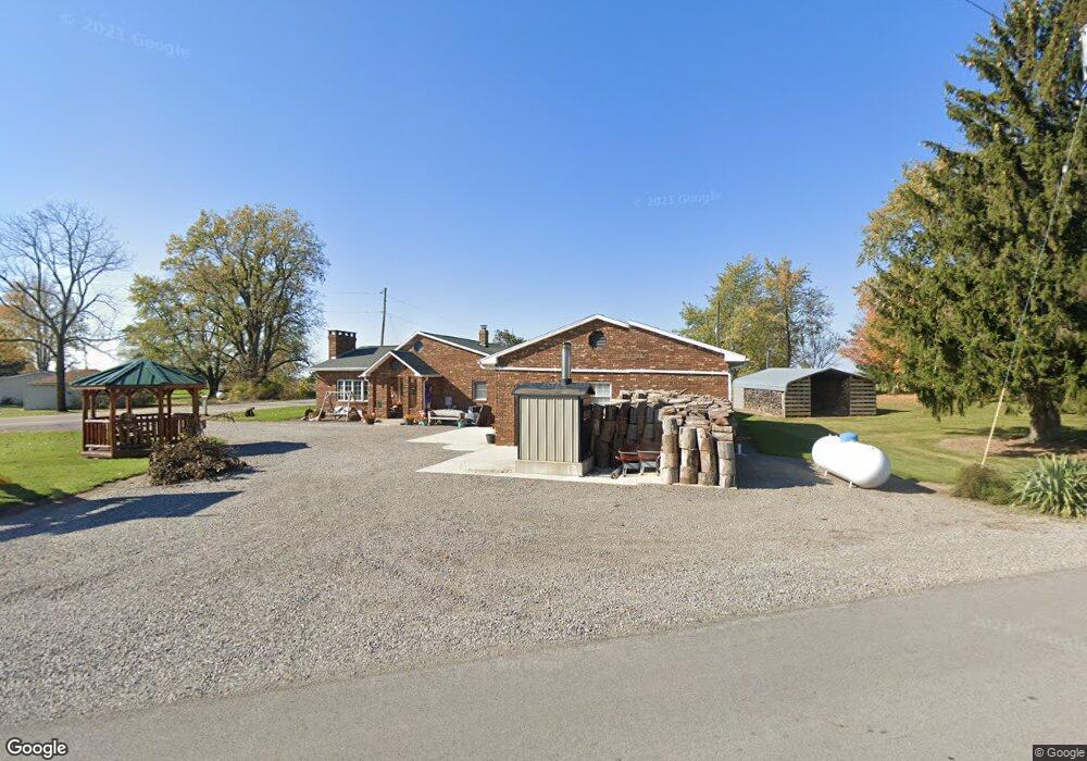
17002 State Route 117 Waynesfield, OH 45896
Estimated Value: $256,966 - $315,000
3
Beds
2
Baths
1,972
Sq Ft
$141/Sq Ft
Est. Value
About This Home
This home is located at 17002 State Route 117, Waynesfield, OH 45896 and is currently estimated at $278,742, approximately $141 per square foot. 17002 State Route 117 is a home located in Auglaize County with nearby schools including Waynesfield-Goshen Local Elementary School and Waynesfield-Goshen Local High School.
Ownership History
Date
Name
Owned For
Owner Type
Purchase Details
Closed on
Apr 5, 2021
Sold by
Good Carl J and Good Lisa D
Bought by
Good Justin C
Current Estimated Value
Purchase Details
Closed on
Nov 2, 1998
Sold by
Good Carl
Bought by
Good Carl J
Create a Home Valuation Report for This Property
The Home Valuation Report is an in-depth analysis detailing your home's value as well as a comparison with similar homes in the area
Home Values in the Area
Average Home Value in this Area
Purchase History
| Date | Buyer | Sale Price | Title Company |
|---|---|---|---|
| Good Justin C | -- | Superior Title | |
| Good Justin C | -- | None Available | |
| Good Carl J | -- | -- |
Source: Public Records
Tax History Compared to Growth
Tax History
| Year | Tax Paid | Tax Assessment Tax Assessment Total Assessment is a certain percentage of the fair market value that is determined by local assessors to be the total taxable value of land and additions on the property. | Land | Improvement |
|---|---|---|---|---|
| 2024 | $4,409 | $70,090 | $3,220 | $66,870 |
| 2023 | $1,211 | $70,090 | $3,220 | $66,870 |
| 2022 | $1,815 | $43,970 | $2,920 | $41,050 |
| 2021 | $891 | $43,970 | $2,920 | $41,050 |
| 2020 | $898 | $43,971 | $2,923 | $41,048 |
| 2019 | $1,449 | $36,642 | $2,436 | $34,206 |
| 2018 | $1,408 | $36,642 | $2,436 | $34,206 |
| 2017 | $1,401 | $36,642 | $2,436 | $34,206 |
| 2016 | $1,055 | $28,382 | $2,321 | $26,061 |
| 2015 | $1,056 | $28,382 | $2,321 | $26,061 |
| 2014 | $1,057 | $28,382 | $2,321 | $26,061 |
| 2013 | $1,173 | $28,382 | $2,321 | $26,061 |
Source: Public Records
Map
Nearby Homes
- 16949 Township Road 39
- 202 Karen St
- 25836 Ohio 67
- 8150 Amherst Rd
- 202 W Mulberry St
- 16049 Ohio 235 Unit 21
- 15527 State Route 235
- 13793 Ohio 235 Unit 75
- 15410 State Route 235 Unit B
- 0 Ash Ave Unit 1041542
- 11455 Oak St
- 11310 Parker Dr
- 16235 Maple Ave
- 11595 Ash Ave
- 11588 Blackhawk Path
- 11377 Township Road 266 Unit 109
- 11377 Township Road 266 Unit 98
- 11377 Township Road 266 Unit 57
- 11377 Township Road 266 Unit 99
- 11377 Township Road 266 Unit 75
- 29983 State Route 67
- 29996 State Route 67
- 14872 County Road 15
- 29988 State Route 67
- 29988 State Route 67
- 29965 State Route 67
- 17031 County Road 15
- 29898 State Route 67
- 17106 State Route 117
- 29898 Ohio 67
- 29878 State Route 67
- 17233 State Route 117
- 15017 State Route 117
- 14888 State Route 117
- 15104 Bellfontaine Rd
- 17313 State Route 117
- 29772 Ohio 67
- 14508 County Road 15
- 14424 County Road 15