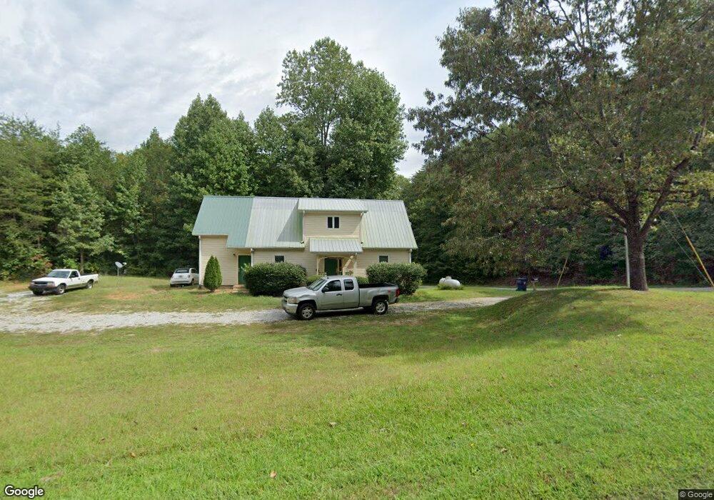
1701 Burnt Stand Rd Dahlonega, GA 30533
Estimated Value: $189,000 - $312,000
--
Bed
--
Bath
1,296
Sq Ft
$191/Sq Ft
Est. Value
About This Home
This home is located at 1701 Burnt Stand Rd, Dahlonega, GA 30533 and is currently estimated at $248,000, approximately $191 per square foot. 1701 Burnt Stand Rd is a home with nearby schools including Lumpkin County High School.
Ownership History
Date
Name
Owned For
Owner Type
Purchase Details
Closed on
Mar 21, 2016
Sold by
Fambrough Investments Llc
Bought by
Hampton Richard M and Hampton Nancy Hampron
Current Estimated Value
Home Financials for this Owner
Home Financials are based on the most recent Mortgage that was taken out on this home.
Original Mortgage
$430,000
Interest Rate
3.65%
Mortgage Type
New Conventional
Purchase Details
Closed on
Jul 25, 2012
Sold by
Fambrough James A
Bought by
Farbrough Investments Llc
Purchase Details
Closed on
May 6, 2011
Sold by
Home Sales Inc
Bought by
Fambrough James A
Purchase Details
Closed on
Dec 7, 2010
Sold by
Kaufman Fred
Bought by
Homesales Inc
Purchase Details
Closed on
Jun 26, 2000
Sold by
Kaufman Fred
Bought by
Kaufman Fred
Purchase Details
Closed on
Jun 14, 2000
Sold by
Fairview 2000 Corp
Bought by
Kaufman Fred
Purchase Details
Closed on
May 2, 1994
Bought by
Fairview 2000 Corp
Create a Home Valuation Report for This Property
The Home Valuation Report is an in-depth analysis detailing your home's value as well as a comparison with similar homes in the area
Home Values in the Area
Average Home Value in this Area
Purchase History
| Date | Buyer | Sale Price | Title Company |
|---|---|---|---|
| Hampton Richard M | $87,000 | -- | |
| Farbrough Investments Llc | -- | -- | |
| Fambrough James A | $54,450 | -- | |
| Homesales Inc | $41,400 | -- | |
| Kaufman Fred | -- | -- | |
| Kaufman Fred | $30,000 | -- | |
| Fairview 2000 Corp | $4,500 | -- |
Source: Public Records
Mortgage History
| Date | Status | Borrower | Loan Amount |
|---|---|---|---|
| Closed | Hampton Richard M | $430,000 |
Source: Public Records
Tax History Compared to Growth
Tax History
| Year | Tax Paid | Tax Assessment Tax Assessment Total Assessment is a certain percentage of the fair market value that is determined by local assessors to be the total taxable value of land and additions on the property. | Land | Improvement |
|---|---|---|---|---|
| 2024 | $1,656 | $69,210 | $9,416 | $59,794 |
| 2023 | $1,513 | $64,332 | $8,560 | $55,772 |
| 2022 | $1,325 | $53,523 | $7,138 | $46,385 |
| 2021 | $1,171 | $45,752 | $7,138 | $38,614 |
| 2020 | $1,171 | $44,392 | $6,840 | $37,552 |
| 2019 | $1,182 | $44,392 | $6,840 | $37,552 |
| 2018 | $1,138 | $40,123 | $6,840 | $33,283 |
| 2017 | $1,007 | $38,273 | $6,840 | $31,433 |
| 2016 | $1,025 | $34,266 | $6,840 | $27,426 |
| 2015 | $912 | $34,266 | $6,840 | $27,426 |
| 2014 | $912 | $34,584 | $6,840 | $27,744 |
| 2013 | -- | $35,219 | $6,840 | $28,379 |
Source: Public Records
Map
Nearby Homes
- 7-/+ Charlie Lemley Rd
- 1405 Burnt Stand Rd
- 0 Charlie Lemley Rd Unit 7693340
- 0 Charlie Lemley Rd Unit 10658696
- 1 Grey Swan Way
- 70 Deerwood Cir
- 183 Grey Swan Way
- 307 Eagle Overlook Dr
- TRACT1 Panorama Dr
- 201 Whelchel Valley Dr
- 328 Jennifer Ct
- 334 Silas Rd
- 0 Eagle Rest Rd Unit 13519388
- 55 Flat Rock Pointe
- 5195 S Chestatee
- 40 Chestatee Springs Rd
- 131 Chestatee Springs Ridge
- 0 Long Branch Rd Unit 10271720
- 0 Long Branch Rd Unit 10271266
- 0 Long Branch Rd Unit 7357871
- 1701 Burnt Stand Rd
- 44 Silver Wood Dr
- 62 Signal Ridge Dr
- 62 Signal Ridge Dr
- 68 Silver Wood Dr
- 77 Shadow Hills Ln
- 127 Signal Ridge Dr
- 89 Shadow Hills Ln
- 69 Shadow Hills Ln
- 135 Shadow Hills Ln
- 1812 Burnt Stand Rd
- 177 Shadow Hills Ln
- 160 Signal Ridge Dr
- 1854 Burnt Stand Rd
- 59 Shadow Hills Ln
- 140 Shadow Hills Ln
- 62 Shadow Hills Ln
- 210 Signal Ridge Dr
- 211 Shadow Hills Ln Unit 17
- 211 Shadow Hills Ln