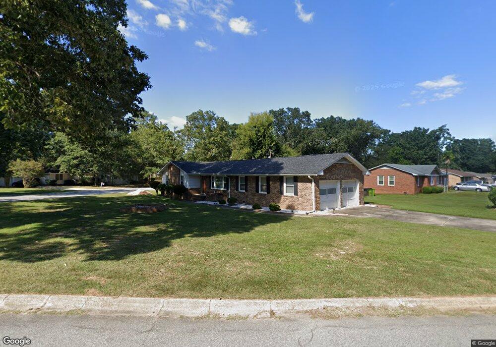
1701 Sapling Dr Columbia, SC 29210
Saint Andrews NeighborhoodEstimated Value: $191,000 - $227,000
3
Beds
2
Baths
1,619
Sq Ft
$126/Sq Ft
Est. Value
About This Home
This home is located at 1701 Sapling Dr, Columbia, SC 29210 and is currently estimated at $204,199, approximately $126 per square foot. 1701 Sapling Dr is a home located in Richland County with nearby schools including H. B. Rhame Elementary School, St. Andrews Middle School, and Columbia High School.
Ownership History
Date
Name
Owned For
Owner Type
Purchase Details
Closed on
Aug 20, 2010
Sold by
Mcelrath Everett Demarco
Bought by
Jeffcoat Cynthia B
Current Estimated Value
Home Financials for this Owner
Home Financials are based on the most recent Mortgage that was taken out on this home.
Original Mortgage
$93,737
Outstanding Balance
$62,624
Interest Rate
4.75%
Mortgage Type
FHA
Estimated Equity
$141,575
Purchase Details
Closed on
Oct 30, 2000
Sold by
Sims James E
Bought by
Mcelrath Everett Demarco
Home Financials for this Owner
Home Financials are based on the most recent Mortgage that was taken out on this home.
Original Mortgage
$84,956
Interest Rate
7.91%
Mortgage Type
FHA
Create a Home Valuation Report for This Property
The Home Valuation Report is an in-depth analysis detailing your home's value as well as a comparison with similar homes in the area
Home Values in the Area
Average Home Value in this Area
Purchase History
| Date | Buyer | Sale Price | Title Company |
|---|---|---|---|
| Jeffcoat Cynthia B | $95,000 | -- | |
| Mcelrath Everett Demarco | $85,000 | -- |
Source: Public Records
Mortgage History
| Date | Status | Borrower | Loan Amount |
|---|---|---|---|
| Open | Jeffcoat Cynthia B | $93,737 | |
| Previous Owner | Mcelrath Everett Demarco | $84,956 |
Source: Public Records
Tax History
| Year | Tax Paid | Tax Assessment Tax Assessment Total Assessment is a certain percentage of the fair market value that is determined by local assessors to be the total taxable value of land and additions on the property. | Land | Improvement |
|---|---|---|---|---|
| 2024 | $834 | $115,900 | $0 | $0 |
| 2023 | $802 | $4,032 | $0 | $0 |
| 2022 | $684 | $100,800 | $12,800 | $88,000 |
| 2021 | $667 | $4,030 | $0 | $0 |
| 2020 | $675 | $4,030 | $0 | $0 |
| 2019 | $643 | $4,030 | $0 | $0 |
| 2018 | $902 | $3,630 | $0 | $0 |
| 2017 | $884 | $3,630 | $0 | $0 |
| 2016 | $880 | $3,630 | $0 | $0 |
| 2015 | $858 | $3,630 | $0 | $0 |
| 2014 | $835 | $90,700 | $0 | $0 |
| 2013 | -- | $3,630 | $0 | $0 |
Source: Public Records
Map
Nearby Homes
- 6 Woodtrail Ct
- 0 Marley Dr Unit 623584
- 1917 Kathleen Dr
- 2103 Marley Dr
- 1725 Kathleen Dr Unit A&B
- 528 Wimbledon Ct
- 2309 Cunningham Rd
- 1913 Grays Inn Rd
- 1613 Ashford Ln
- 1908 Grays Inn Rd
- 1533 Westchester Dr
- 2135 Rolling Hills Rd
- 1540 Romain Dr
- 2309 Hillbeck Dr
- 1900 Rolling Hills Rd
- 1705 Saint Michaels Rd
- 2341 Rolling Hills Rd
- 1657 Omarest Dr
- 1650 Omarest Dr
- 1727 Omarest Dr
- 1709 Sapling Dr
- 1624 Nunamaker Dr
- 1700 Sapling Dr
- 1713 Sapling Dr
- 1704 Sapling Dr
- 1617 Nunamaker Dr
- 1708 Sapling Dr
- 1621 Nunamaker Dr
- 1712 Sapling Dr
- 1613 Nunamaker Dr
- 1625 Nunamaker Dr
- 1717 Sapling Dr
- 1900 Woodtrail Dr
- 1612 Nunamaker Dr
- 1904 Woodtrail Dr
- 18 Woodtrail Ct
- 1609 Nunamaker Dr
- 14 Woodtrail Ct
- 1720 Sapling Dr
- 1830 Woodtrail Dr
Your Personal Tour Guide
Ask me questions while you tour the home.