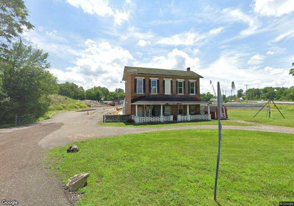
1701 Woodsdale Rd Trenton, OH 45067
Estimated Value: $274,000 - $337,000
3
Beds
1
Bath
2,080
Sq Ft
$140/Sq Ft
Est. Value
About This Home
This home is located at 1701 Woodsdale Rd, Trenton, OH 45067 and is currently estimated at $292,120, approximately $140 per square foot. 1701 Woodsdale Rd is a home located in Butler County with nearby schools including Edgewood Intermediate School and Edgewood High School.
Ownership History
Date
Name
Owned For
Owner Type
Purchase Details
Closed on
Aug 30, 2013
Sold by
Tongdangioue Pongkiet and Tongdangioue Dana A
Bought by
Ryder Robert L
Current Estimated Value
Home Financials for this Owner
Home Financials are based on the most recent Mortgage that was taken out on this home.
Original Mortgage
$115,706
Outstanding Balance
$86,104
Interest Rate
4.33%
Mortgage Type
Purchase Money Mortgage
Estimated Equity
$206,016
Purchase Details
Closed on
Aug 14, 2008
Sold by
First Financial Bank Na and Vickers Floyd E
Bought by
Tongdangjoue Pongkieat and Tongdangjoue Dana A
Purchase Details
Closed on
Jun 13, 1996
Sold by
Reece David
Bought by
Trustee First National Bank Southwest Ohio
Create a Home Valuation Report for This Property
The Home Valuation Report is an in-depth analysis detailing your home's value as well as a comparison with similar homes in the area
Home Values in the Area
Average Home Value in this Area
Purchase History
| Date | Buyer | Sale Price | Title Company |
|---|---|---|---|
| Ryder Robert L | $125,000 | None Available | |
| Tongdangjoue Pongkieat | $125,000 | Attorney | |
| Trustee First National Bank Southwest Ohio | $36,000 | -- |
Source: Public Records
Mortgage History
| Date | Status | Borrower | Loan Amount |
|---|---|---|---|
| Open | Ryder Robert L | $115,706 |
Source: Public Records
Tax History Compared to Growth
Tax History
| Year | Tax Paid | Tax Assessment Tax Assessment Total Assessment is a certain percentage of the fair market value that is determined by local assessors to be the total taxable value of land and additions on the property. | Land | Improvement |
|---|---|---|---|---|
| 2024 | $2,610 | $65,090 | $18,840 | $46,250 |
| 2023 | $2,641 | $65,090 | $18,840 | $46,250 |
| 2022 | $2,307 | $49,680 | $18,840 | $30,840 |
| 2021 | $2,063 | $49,680 | $18,840 | $30,840 |
| 2020 | $2,216 | $49,680 | $18,840 | $30,840 |
| 2019 | $2,515 | $37,180 | $18,840 | $18,340 |
| 2018 | $1,760 | $37,180 | $18,840 | $18,340 |
| 2017 | $1,761 | $37,180 | $18,840 | $18,340 |
| 2016 | $1,669 | $34,770 | $18,840 | $15,930 |
| 2015 | $1,528 | $34,770 | $18,840 | $15,930 |
| 2014 | $2,076 | $34,770 | $18,840 | $15,930 |
| 2013 | $2,076 | $43,000 | $18,840 | $24,160 |
Source: Public Records
Map
Nearby Homes
- 5433 Augspurger Rd
- 5192 Kennedy Camp Rd
- 5354 River Ridge Dr
- 4097 Fairfield Falls Ct
- 5467 Pacific Crest Ln
- 0 Liberty Square Dr
- 5475 Timberhill Dr
- 5014 Rockdale Rd
- 5549 Birch Ct
- 3972 Olinger Ln
- 3980 Olinger Ln
- 3984 Olinger Ln
- 5609 Birch Ct
- 3976 Olinger Ln
- 5608 Birch Ct
- Barrett Plan at Timberhill - Classic Series
- Dawson Plan at Timberhill - Classic Series
- Hampton Plan at Timberhill - Classic Series
- Cooke Plan at Timberhill - Classic Series
- Cheswicke Plan at Timberhill - Classic Series
- 1670 Wayne Madison Rd
- 1723 Woodsdale Rd
- 1678 Wayne Madison Rd
- 1686 Wayne Madison Rd
- 1585 Wayne Madison Rd
- 1585 Wayne Madison Rd Unit 1585
- 1659 Wayne Madison Rd
- 1710 Woodsdale Rd
- 1661 Wayne Madison Rd
- 1692 Wayne Madison Rd
- 1650 Wayne Madison Rd
- 1671 Wayne Madison Rd
- 1681 Wayne Madison Rd
- 0 Wayne Madison Rd
- 0 Wayne Madison Rd Unit 1078659
- 0 Wayne Madison Rd Unit 1045900
- 0 Wayne Madison Rd Unit 1011548
- 0 Wayne Madison Rd Unit 804984
- 0 Wayne Madison Rd Unit 685015
- 0 Wayne Madison Rd Unit 3 570348