NOT LISTED FOR SALE

1702 SE Texas Cir Unit Lot 36 Prineville, OR 97754

Juniper Canyon Neighborhood

Estimated Value: $116,689 - $614,000

5 Acres
$73,069 Price per Acre
217,800 Sq Ft Lot

Last Sold May 22, 2024

Last sale price $115,000

Est. 218% increase in value since last sale

Current estimated payment $2,124/month

348 Days on Market

Highlights

  • Gated Community
  • Mountain View
  • Trails
  • 5 Acre Lot
  • Property is near a preserve or public land

About This Lot

As of May 2024

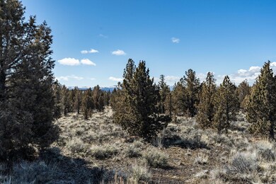
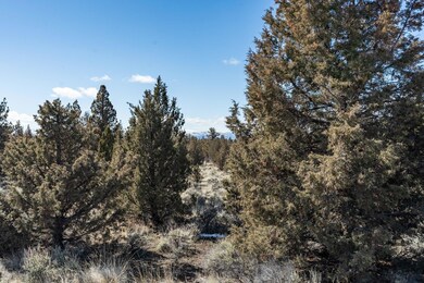
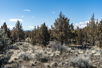
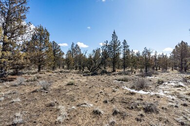
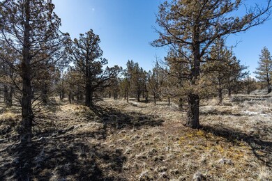
Build your own custom home on 5 acres behind the gates of Longhorn Ridge. Longhorn Ridge is a subdivision 10.5 miles from the township of Prineville. This five-acre parcel features Peak-a-boo mountain views, and butte/terrain views. There is lots of space to build your dream home and the already established well house that is fully functional and power is available at the street. The area provides a setting of rolling high desert hills, and lovely homes nestled amongst the natural junipers. Streets are wide and freshly paved. Come build your dream home today. Minutes to Prineville Reservoir for epic water sports, and the Crooked River for fly fishing, hiking and enjoyment of all things nature. This is truly a lovely area and an all-around great subdivision.

Last Agent to Sell the Property

Teri Axmaker

West and Main Homes Brokerage Email: hello@westandmainoregon.com License #200510137 Listed on: 04/01/2023

Last Buyer's Agent

Mark Morzov

Cascade Hasson SIR License #201215826

Property Details

Property Type

  • Land

Est. Annual Taxes

  • $878

Lot Details

  • 5 Acre Lot
  • Property is zoned Rrm5; Recreatio, Rrm5; Recreatio

HOA Fees

  • $55 Monthly HOA Fees

Schools

  • Crook County Middle School
  • Crook County High School

Additional Features

  • Mountain Views
  • Shared Well

Listing and Financial Details

  • No Short Term Rentals Allowed
  • Tax Lot 36
  • Assessor Parcel Number 17799

Community Details

Overview

  • Longhorn Ridge Subdivision
  • Property is near a preserve or public land

Recreation

  • Trails
  • Snow Removal

Security

  • Gated Community

Property Details

Property Type

Land

Est. Annual Taxes

$878

Lot Details

0

HOA Fees

$55 per month

Listing Details

  • Directions: SE Juniper Canyon Rd, go approx. 2.5 miles, turn R onto SE Davis Loop, go approx 3.5 miles, turn left into Longhorn Ridge main entrance. Follow Texas Circle. to Lot 36.
  • Garage Yn: No
  • Lot Size Acres: 5.0
  • Prop. Type: Land
  • Property Sub Type: Residential Lots
  • Road Frontage Type: Private Access
  • Road Surface Type: Paved
  • Subdivision Name: Longhorn Ridge
  • Attribution Contact: hello@westandmainoregon.com
  • Co List Office Phone: 541-647-6556
  • MLS Status: Closed
  • General Property Information Elementary School: Check with District
  • General Property Information Middle Or Junior School: Crook County Middle
  • General Property Information High School: Crook County High
  • General Property Information:Zoning2: Rrm5; Recreatio
  • General Property Information Senior Community YN: No
  • General Property Information Horse Property YN: No
  • General Property Information Audio Surveillance on Premises YN: No
  • Road Surface Type:Paved: Yes
  • Community Features Short Term Rentals Not Allowed: Yes
  • Utilities:Electricity Available: Yes
  • Location Tax and Legal:Tax Lot: 36
  • Location Tax and Legal:Tax Block: 0
  • View:Mountain(s): Yes
  • Sewer:None6: Yes
  • Water Source Shared Well: Yes
  • Special Features: None

Exterior Features

  • Other Structures: Other
  • View: Mountain(s)
  • Fencing: None
  • Horse: No

Garage/Parking

  • General Property Information:Garage YN: No

Utilities

  • Sewer: None
  • Water Source: Shared Well
  • Utilities: Electricity Available

Condo/Co-op/Association

  • Amenities: Gated, Snow Removal, Trail(s)
  • Association Fee: 660.0
  • Association Fee Frequency: Annually
  • Association: Yes
  • Community Features: Access to Public Lands, Short Term Rentals Not Allowed
  • Senior Community: No

Association/Amenities

  • General Property Information:Association YN: Yes
  • General Property Information:Association Fee: 660.0
  • General Property Information:Association Fee Frequency: Annually
  • Association Amenities:Gated: Yes
  • Association Amenities:Snow Removal: Yes

Schools

  • Elementary School: Check with District
  • High School: Crook County High
  • Middle Or Junior School: Crook County Middle

Lot Info

  • Additional Parcels: No
  • Lot Size Sq Ft: 217800.0
  • Parcel #: 17799
  • Irrigation Water Rights: No
  • Current Use: Vacant
  • ResoLotSizeUnits: Acres
  • Zoning Description: Rrm5; Recreatio
  • ResoLotSizeUnits: Acres

Tax Info

  • Tax Annual Amount: 878.36
  • Tax Block: 0
  • Tax Lot: 36
  • Tax Map Number: 161604B001400
  • Tax Year: 2022

Ownership History

Date Name Owned For Owner Type

Purchase Details

Listed on
Apr 1, 2023
Closed on
May 8, 2024
Sold by
Anderson Tom and Anderson Julie
Bought by
Madtson Marvin W and Madtson Darla A
Seller's Agent
Teri Axmaker
West and Main Homes
Buyer's Agent
Mark Morzov
Cascade Hasson SIR
List Price
$109,000
Sold Price
$115,000
Premium/Discount to List
$6,000
5.5%
Views
197
Current Estimated Value
$365,345

Home Financials for this Owner

Home Financials are based on the most recent Mortgage that was taken out on this home.
Estimated Appreciation
$250,345
Avg. Annual Appreciation
-1.32%
Original Mortgage
$584,307
Interest Rate
4%
Mortgage Type
VA

Purchase Details

Closed on
Apr 28, 2006
Sold by
Edge Vertical Development Corp
Bought by
Anderson Tom and Anderson Julie
Source: Public Records

Range of Values:

Collateral Analytics

Collateral Analytics Collateral Analytics AVMs (Automated Valuation Model) employ a number of statistical approaches combined with neighborhood-specific comparable selection guarantees the most up-to-date and precise valuations.

Not Available

Collateral Analytics does not have data for the current month. Please view the chart for historical values.

ICE

ICE Mortgage Technology ICE Mortgage Technology’s AVM (Automated Valuation Model) is a state-of-the-art online residential property valuation tool that provides a quick and accurate estimate of the value of almost any home in the U.S.

Not Available

ICE Mortgage Technology does not have data for the current month. Please view the chart for historical values.

First American

First American First American Data & Analytics’ next-generation AVM combines unrivaled data assets with a blended ensemble of valuation models to produce highly accurate, reliable valuations you can trust.

Not Available

First American does not have data for the current month. Please view the chart for historical values.

Quantarium

Quantarium Quantarium’s valuation service, repeatedly proven the industry’s most accurate and comprehensive, is supercharged with a self-learning and auto-tuning AI engine that continually becomes smarter and more accurate as it processes daily inputs from the industry’s leading RE data lake.

Not Available

Quantarium does not have data for the current month. Please view the chart for historical values.

Average Value
Not Available
List Price
Sold Price
Create a Home Valuation Report for This Property
The Home Valuation Report is an in-depth analysis detailing your home's value as well as a comparison with similar homes in the area

Home Values in the Area

Source: Public Records

Average Home Value in this Area


Source: Public Records

Purchase History

Date Buyer Sale Price Title Company
Madtson Marvin W $115,000 Deschutes County Title
Anderson Tom $149,900 Amertitle
Source: Public Records

Mortgage History

Date Status Borrower Loan Amount
Open Madtson Marvin W $557,774
Closed Madtson Marvin W $584,307
Source: Public Records

Property History

Date Event Price Change Sq Ft Price
05/22/2024 05/22/24 Sold $115,000 +5.5% --
03/14/2024 03/14/24 Pending -- -- --
04/01/2023 04/01/23 For Sale $109,000 -- --
Source: Oregon Datashare

Tax History Compared to Growth

Source: Public Records

Tax History

Year Tax Paid Tax Assessment Tax Assessment Total Assessment is a certain percentage of the fair market value that is determined by local assessors to be the total taxable value of land and additions on the property. Land Improvement
2024 $939 $76,870 -- --
2023 $907 $74,640 $0 $0
2022 $878 $72,470 $0 $0
2021 $659 $54,990 $0 $0
2020 $593 $49,380 $0 $0
2019 $536 $42,010 $0 $0
2018 $503 $42,010 $0 $0
2017 $605 $49,780 $0 $0
2016 $535 $44,840 $0 $0
2015 $527 $44,840 $0 $0
2013 -- $29,090 $0 $0
Source: Public Records

Agents Affiliated with this Home

  • Section Image
See All Agents

Map

Source: Oregon Datashare

MLS Number: 220161502

Oregon Datashare

APN: 017799