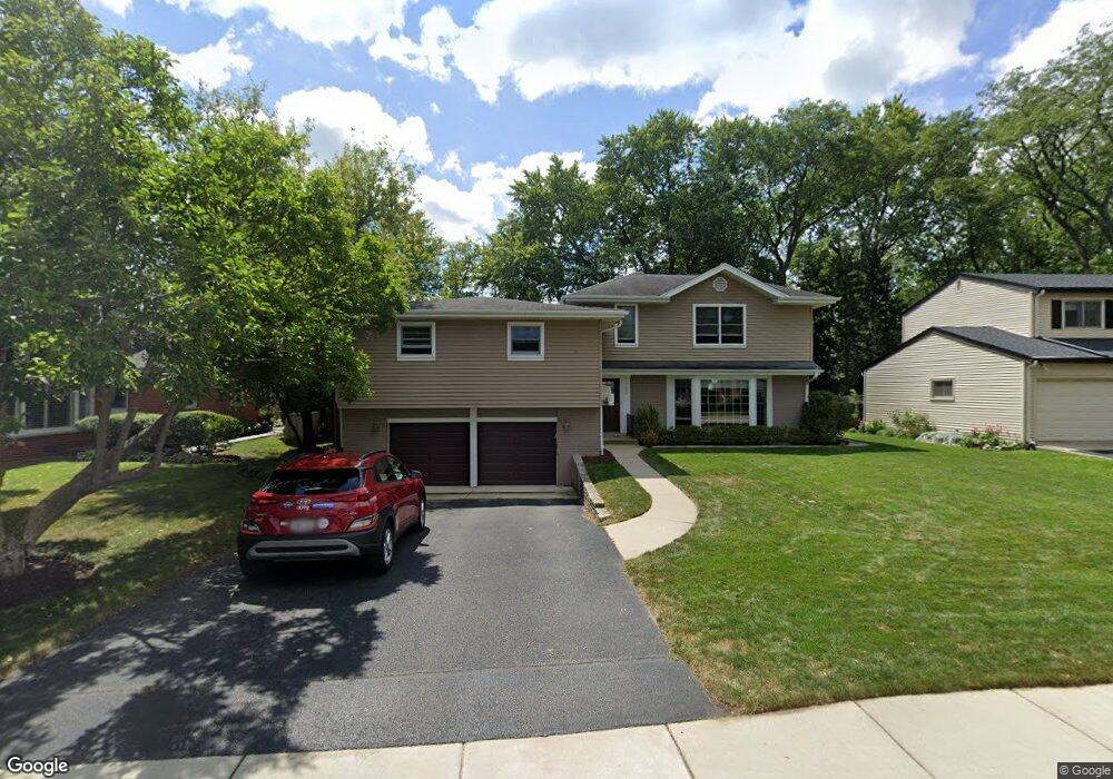
1703 Cranshire Ct Deerfield, IL 60015
Deerfield Park NeighborhoodEstimated Value: $650,000 - $768,000
4
Beds
3
Baths
2,701
Sq Ft
$262/Sq Ft
Est. Value
About This Home
This home is located at 1703 Cranshire Ct, Deerfield, IL 60015 and is currently estimated at $706,585, approximately $261 per square foot. 1703 Cranshire Ct is a home located in Lake County with nearby schools including Wilmot Elementary School, Charles J Caruso Middle School, and Deerfield High School.
Ownership History
Date
Name
Owned For
Owner Type
Purchase Details
Closed on
Sep 21, 2021
Sold by
Rosenzweig Michael David and Case-Rosenzweig Cathleen
Bought by
Michael David Rosenzweig Living Trust and Cathleen Case Rosenzweig Living Trust
Current Estimated Value
Home Financials for this Owner
Home Financials are based on the most recent Mortgage that was taken out on this home.
Original Mortgage
$481,000
Interest Rate
3.45%
Mortgage Type
New Conventional
Purchase Details
Closed on
Apr 29, 2015
Sold by
Rosenzweig Michael D and Rosenzweig Cathleen
Bought by
Michael David Roserweig Living Trust
Create a Home Valuation Report for This Property
The Home Valuation Report is an in-depth analysis detailing your home's value as well as a comparison with similar homes in the area
Home Values in the Area
Average Home Value in this Area
Purchase History
| Date | Buyer | Sale Price | Title Company |
|---|---|---|---|
| Michael David Rosenzweig Living Trust | -- | Amrock | |
| Rosenzweig Michael David | -- | None Listed On Document | |
| Michael David Roserweig Living Trust | -- | None Available |
Source: Public Records
Mortgage History
| Date | Status | Borrower | Loan Amount |
|---|---|---|---|
| Previous Owner | Rosenzweig Michael David | $481,000 |
Source: Public Records
Tax History Compared to Growth
Tax History
| Year | Tax Paid | Tax Assessment Tax Assessment Total Assessment is a certain percentage of the fair market value that is determined by local assessors to be the total taxable value of land and additions on the property. | Land | Improvement |
|---|---|---|---|---|
| 2024 | $15,007 | $174,468 | $48,561 | $125,907 |
| 2023 | $15,659 | $167,436 | $46,604 | $120,832 |
| 2022 | $15,659 | $171,253 | $50,057 | $121,196 |
| 2021 | $14,771 | $165,111 | $48,262 | $116,849 |
| 2020 | $14,206 | $165,459 | $48,364 | $117,095 |
| 2019 | $13,881 | $165,178 | $48,282 | $116,896 |
| 2018 | $11,939 | $148,624 | $51,174 | $97,450 |
| 2017 | $11,843 | $148,150 | $51,011 | $97,139 |
| 2016 | $11,513 | $142,548 | $49,082 | $93,466 |
| 2015 | $11,270 | $133,936 | $46,117 | $87,819 |
| 2014 | $9,882 | $116,602 | $46,447 | $70,155 |
| 2012 | -- | $115,573 | $46,037 | $69,536 |
Source: Public Records
Map
Nearby Homes
- 1119 Hampton Ct Unit 1
- 1660 Hertel Ln
- 1620 Berkeley Ct
- 730 Castlewood Ln
- 816 Appletree Ln
- 926 Cedar St
- 1410 Berkley Ct
- 1670 Meadow Ln
- 1265 Woodland Dr
- 2260 Congressional Ln
- 677 Timber Hill Rd
- 1131 Linden Ave
- 517 Appletree Ln
- 505 Susan Ln
- 1103 Hazel Ave
- 1045 Fairoaks Ave
- 2419 Riverwoods Rd
- 2635 Crestwood Ln
- 904 Forest Ave
- 1342 Barclay Ln Unit 36
- 1150 Castlewood Ln
- 1705 Cranshire Ct Unit 2
- 1704 Garand Dr
- 1700 Garand Dr
- 1709 Cranshire Ct
- 0 Cranshire Ct
- 1704 Cranshire Ct
- 1710 Garand Dr
- 1700 Cranshire Ct
- 1706 Cranshire Ct Unit 2
- 1675 Cranshire Ct
- 1678 Cranshire Ct
- 1117 Montgomery Dr
- 1676 Garand Dr
- 1708 Cranshire Ct
- 1115 Montgomery Dr
- 1674 Cranshire Ct
- 1701 Garand Dr
- 1714 Garand Dr Unit 2
- 1714 Cranshire Ct