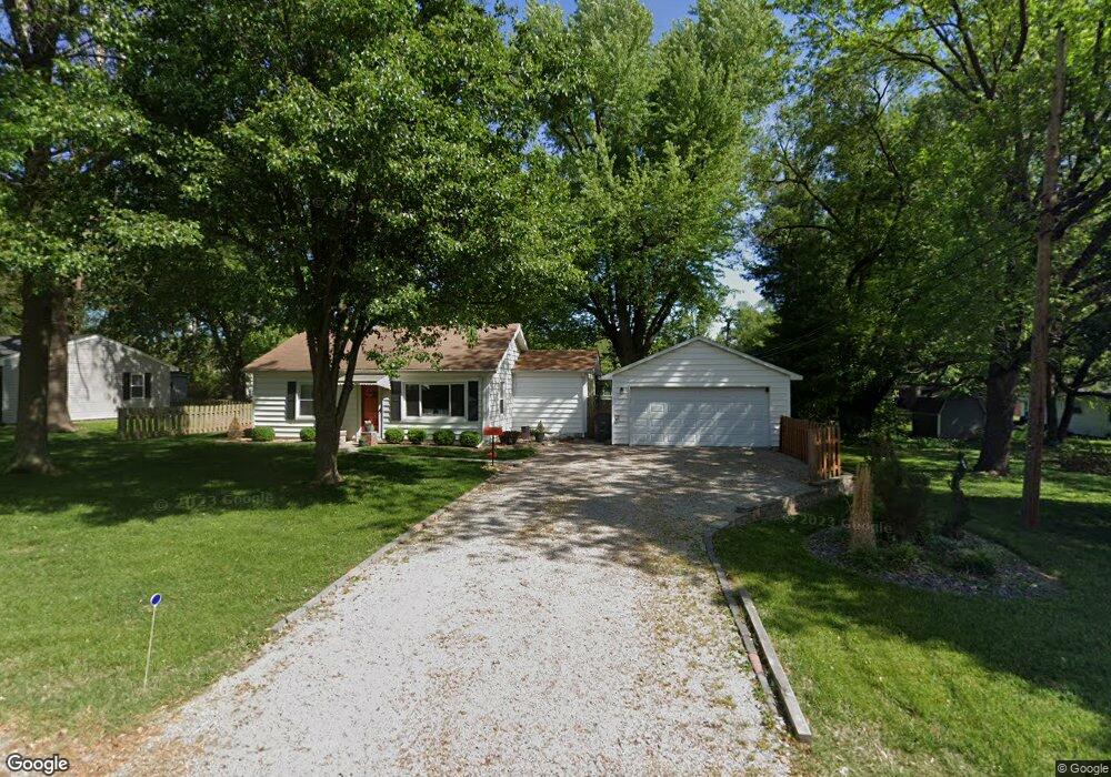
1703 Jay Ave Swansea, IL 62226
Estimated Value: $106,000 - $122,948
2
Beds
1
Bath
840
Sq Ft
$140/Sq Ft
Est. Value
About This Home
This home is located at 1703 Jay Ave, Swansea, IL 62226 and is currently estimated at $117,487, approximately $139 per square foot. 1703 Jay Ave is a home located in St. Clair County with nearby schools including Abraham Lincoln Elementary School, West Jr High School, and Elite Scholars STEAM Academy.
Ownership History
Date
Name
Owned For
Owner Type
Purchase Details
Closed on
Mar 28, 2008
Sold by
Stenger Jennifer K
Bought by
Roarty Joshua T
Current Estimated Value
Home Financials for this Owner
Home Financials are based on the most recent Mortgage that was taken out on this home.
Original Mortgage
$75,810
Outstanding Balance
$47,570
Interest Rate
5.79%
Mortgage Type
Purchase Money Mortgage
Estimated Equity
$69,917
Purchase Details
Closed on
Aug 29, 2002
Sold by
Marconi Harry J and Marconi Lisa T
Bought by
Stenger Jennifer K
Home Financials for this Owner
Home Financials are based on the most recent Mortgage that was taken out on this home.
Original Mortgage
$58,700
Interest Rate
6.56%
Mortgage Type
FHA
Create a Home Valuation Report for This Property
The Home Valuation Report is an in-depth analysis detailing your home's value as well as a comparison with similar homes in the area
Home Values in the Area
Average Home Value in this Area
Purchase History
| Date | Buyer | Sale Price | Title Company |
|---|---|---|---|
| Roarty Joshua T | $80,000 | Town & Country Title Co | |
| Stenger Jennifer K | $61,000 | Town & Country Title Co |
Source: Public Records
Mortgage History
| Date | Status | Borrower | Loan Amount |
|---|---|---|---|
| Open | Roarty Joshua T | $75,810 | |
| Previous Owner | Stenger Jennifer K | $58,700 | |
| Closed | Stenger Jennifer K | $5,835 |
Source: Public Records
Tax History Compared to Growth
Tax History
| Year | Tax Paid | Tax Assessment Tax Assessment Total Assessment is a certain percentage of the fair market value that is determined by local assessors to be the total taxable value of land and additions on the property. | Land | Improvement |
|---|---|---|---|---|
| 2024 | $2,604 | $29,612 | $8,544 | $21,068 |
| 2023 | $2,455 | $26,149 | $8,377 | $17,772 |
| 2022 | $2,253 | $23,540 | $7,541 | $15,999 |
| 2021 | $2,170 | $21,762 | $6,971 | $14,791 |
| 2020 | $1,502 | $20,579 | $6,592 | $13,987 |
| 2019 | $1,753 | $22,917 | $6,602 | $16,315 |
| 2018 | $1,700 | $22,421 | $6,459 | $15,962 |
| 2017 | $1,688 | $22,263 | $6,414 | $15,849 |
| 2016 | $1,661 | $21,790 | $6,278 | $15,512 |
| 2014 | $1,636 | $23,694 | $6,517 | $17,177 |
| 2013 | $1,669 | $24,033 | $6,610 | $17,423 |
Source: Public Records
Map
Nearby Homes
- 1601 N 17th St
- 1900 N 17th St
- 1903 N 17th St
- 1708 Anna Rose Dr
- 1601 Foster Dr
- 24 Queensway Dr
- 145 Marilyn Dr
- 13 Blackburn Dr
- 20 Exeter Ln
- 20 Chaucer Dr
- 3705 Little Flower Ln
- 515 N 37th St
- 435 N 38th St
- 141 N 31st St
- 105 N 35th St
- 107 N 36th St
- 639 Royal Heights Rd
- 639 N 38th St
- 3204 W Main St
- 111 N 39th St
- 1705 Jay Ave
- 1703 N 17th St
- 54 Lillian Dr
- 50 Lillian Dr
- 58 Lillian Dr
- 1616 Berkley Ln
- 46 Lillian Dr
- 1725 N 17th St
- 1617 N 17th St
- 42 Lillian Dr
- 1614 Berkley Ln
- 1709 W Jay St Unit A & B
- 1709 Jay Ave
- 1709 Jay Ave Unit A & B
- 1615 N 17th St
- 1621 Berkley Ln
- 38 Lillian Dr
- 55 Lillian Dr
- 59 Lillian Dr
- 47 Lillian Dr