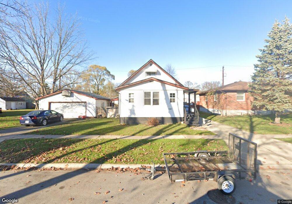
1703 McBrady St Port Huron, MI 48060
Estimated Value: $146,000 - $168,723
3
Beds
1
Bath
1,082
Sq Ft
$147/Sq Ft
Est. Value
About This Home
This home is located at 1703 McBrady St, Port Huron, MI 48060 and is currently estimated at $159,181, approximately $147 per square foot. 1703 McBrady St is a home located in St. Clair County with nearby schools including H.D. Crull Elementary School, Holland Woods Middle School, and Port Huron Northern High School.
Ownership History
Date
Name
Owned For
Owner Type
Purchase Details
Closed on
Jan 5, 2010
Sold by
Belton Tina and Belton Bill
Bought by
Lutze Brenda J
Current Estimated Value
Home Financials for this Owner
Home Financials are based on the most recent Mortgage that was taken out on this home.
Original Mortgage
$59,895
Outstanding Balance
$39,104
Interest Rate
4.84%
Mortgage Type
FHA
Estimated Equity
$120,077
Purchase Details
Closed on
Oct 9, 2009
Sold by
Belton Tina
Bought by
Belton Tina and Belton Bill
Create a Home Valuation Report for This Property
The Home Valuation Report is an in-depth analysis detailing your home's value as well as a comparison with similar homes in the area
Home Values in the Area
Average Home Value in this Area
Purchase History
| Date | Buyer | Sale Price | Title Company |
|---|---|---|---|
| Lutze Brenda J | $61,000 | Maritime Title Agency Llc | |
| Belton Tina | -- | None Available |
Source: Public Records
Mortgage History
| Date | Status | Borrower | Loan Amount |
|---|---|---|---|
| Open | Lutze Brenda J | $59,895 |
Source: Public Records
Tax History Compared to Growth
Tax History
| Year | Tax Paid | Tax Assessment Tax Assessment Total Assessment is a certain percentage of the fair market value that is determined by local assessors to be the total taxable value of land and additions on the property. | Land | Improvement |
|---|---|---|---|---|
| 2025 | $1,584 | $69,000 | $0 | $0 |
| 2024 | $1,311 | $64,900 | $0 | $0 |
| 2023 | $1,239 | $57,900 | $0 | $0 |
| 2022 | $1,259 | $49,400 | $0 | $0 |
| 2021 | $1,196 | $45,700 | $0 | $0 |
| 2020 | $1,209 | $42,600 | $42,600 | $0 |
| 2019 | $1,188 | $29,700 | $0 | $0 |
| 2018 | $1,161 | $29,700 | $0 | $0 |
| 2017 | $1,038 | $27,900 | $0 | $0 |
| 2016 | $880 | $27,900 | $0 | $0 |
| 2015 | $864 | $25,400 | $25,400 | $0 |
| 2014 | $864 | $24,100 | $24,100 | $0 |
| 2013 | -- | $24,200 | $0 | $0 |
Source: Public Records
Map
Nearby Homes
- 1733 Whipple St
- 1649 Whipple St
- 1819 Riverside Dr
- 1907 Riverside Dr
- 1620 McBrady St
- 0000 Campau Ave
- 1433 Poplar St
- 29 Taylor St
- 1417 Kearney St
- 1819 Kern St
- 2215 Hancock St
- 1825 Kern St
- 2838 Elmwood St
- 1321 Nelson St
- 146 Taylor St
- 00 Campau Ave
- 2400 Stone St Unit 2414
- 2736 17th Ave
- 2549 Riverwood Dr
- 1116 Hancock St
- 1709 McBrady St
- 1685 McBrady St
- 1704 McBrady St
- 1713 McBrady St
- 1728 Mcpherson St
- 1732 Mcpherson St
- 1702 McBrady St
- 1688 McBrady St
- 1722 Mcpherson St
- 1706 McBrady St
- 1716 Mcpherson St
- 1744 Mcpherson St
- 1682 McBrady St
- 1752 Mcpherson St
- 1712 Mcpherson St
- 1673 McBrady St
- 1712 Mc Pherson Mc Pherson
- 1710 Mcpherson St
- 1718 McBrady St Unit 1720
- 1678 McBrady St