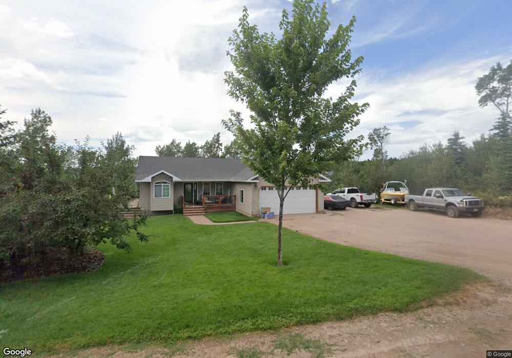
1705 Aspen Heights Dr Ashton, ID 83420
Estimated Value: $501,000 - $767,000
4
Beds
2
Baths
2,476
Sq Ft
$257/Sq Ft
Est. Value
About This Home
This home is located at 1705 Aspen Heights Dr, Ashton, ID 83420 and is currently estimated at $635,934, approximately $256 per square foot. 1705 Aspen Heights Dr is a home with nearby schools including Ashton Elementary School and North Fremont Junior/Senior High School.
Ownership History
Date
Name
Owned For
Owner Type
Purchase Details
Closed on
May 26, 2009
Sold by
Packer Corey and Packer Jaylee
Bought by
Packer Corey and Packer Jaylee A
Current Estimated Value
Home Financials for this Owner
Home Financials are based on the most recent Mortgage that was taken out on this home.
Original Mortgage
$163,000
Interest Rate
5.59%
Mortgage Type
New Conventional
Create a Home Valuation Report for This Property
The Home Valuation Report is an in-depth analysis detailing your home's value as well as a comparison with similar homes in the area
Home Values in the Area
Average Home Value in this Area
Purchase History
| Date | Buyer | Sale Price | Title Company |
|---|---|---|---|
| Packer Corey | -- | -- |
Source: Public Records
Mortgage History
| Date | Status | Borrower | Loan Amount |
|---|---|---|---|
| Previous Owner | Packer Corey | $163,000 |
Source: Public Records
Tax History Compared to Growth
Tax History
| Year | Tax Paid | Tax Assessment Tax Assessment Total Assessment is a certain percentage of the fair market value that is determined by local assessors to be the total taxable value of land and additions on the property. | Land | Improvement |
|---|---|---|---|---|
| 2025 | $1,235 | $316,644 | $84,000 | $232,644 |
| 2024 | $1,235 | $289,754 | $84,000 | $205,754 |
| 2023 | $1,163 | $289,754 | $84,000 | $205,754 |
| 2022 | $1,218 | $167,496 | $26,280 | $141,216 |
| 2021 | $973 | $94,468 | $25,240 | $69,228 |
| 2020 | $992 | $90,434 | $25,240 | $65,194 |
| 2019 | $982 | $90,434 | $25,240 | $65,194 |
| 2018 | $997 | $87,208 | $25,240 | $61,968 |
| 2017 | $11 | $84,039 | $24,483 | $59,556 |
| 2016 | $1,075 | $84,039 | $24,483 | $59,556 |
| 2015 | $1,061 | $168,079 | $0 | $0 |
| 2014 | $864 | $82,963 | $0 | $0 |
| 2013 | $864 | $84,928 | $0 | $0 |
Source: Public Records
Map
Nearby Homes
- 1703 Mountain Laurel Dr
- TBD Aspen Heights Dr
- 1640 Ashton Hill Loop
- 1635 W Ashton Hill Loop
- TBD Fishermans Dr
- TBD Marysville Hill Rd
- 3656 Fishermans Dr
- 1413 U S 20
- 4373 Hannah's Crossing
- 1542 W Rim Loop
- 1550 W Rim Loop
- 1550 E Rim Loop Rd
- 1560 E Rim Loop Rd
- 540 N 4th St Unit 4
- 540 N 4th St Unit 2
- 540 N 4th St Unit 3
- 137 Spruce St
- TBD Annies Landing
- 885 Maple St
- 1331 N 3687 E
- 1707 Aspen Heights Dr
- 1713 Mountain Laurel Dr
- 1709 Mountain Maple Dr
- 1704 Aspen Heights Dr
- 1711 W Aspen Heights Dr
- 1711 Aspen Heights Dr
- 1699 E Aspen Heights Dr
- 1704 Mountain Laurel Dr
- 1715 Mountain Maple Ln
- 1715 Maple Leaf Dr
- 1694 E Aspen Heights Dr
- 1693 E Aspen Heights Dr
- 1709 Mountain Maple Ln
- 1695 E Aspen Heights Dr
- 1699 Mountain Laurel Dr
- 1690 E Aspen Heights Dr
- 1689 E Aspen Heights Dr Unit 10
- 1689 E Aspen Heights Dr
- 1694 Aspen Heights Dr
- 000 Mountain Laurel Dr