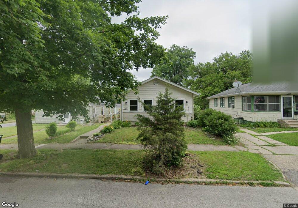
1705 E Donald St South Bend, IN 46613
Estimated Value: $90,000 - $114,809
2
Beds
1
Bath
761
Sq Ft
$142/Sq Ft
Est. Value
About This Home
This home is located at 1705 E Donald St, South Bend, IN 46613 and is currently estimated at $108,202, approximately $142 per square foot. 1705 E Donald St is a home located in St. Joseph County with nearby schools including Lincoln Elementary School, Marshall Traditional School, and Clay Intermediate Center.
Ownership History
Date
Name
Owned For
Owner Type
Purchase Details
Closed on
Aug 12, 2008
Sold by
Rete Land Trust
Bought by
Merley Debra K
Current Estimated Value
Home Financials for this Owner
Home Financials are based on the most recent Mortgage that was taken out on this home.
Original Mortgage
$0
Interest Rate
6.31%
Mortgage Type
Stand Alone Second
Purchase Details
Closed on
Apr 19, 2007
Sold by
Potter John C
Bought by
Us Bank National Assn
Purchase Details
Closed on
Apr 29, 2005
Sold by
Ungerecht Eric
Bought by
Potter John C
Home Financials for this Owner
Home Financials are based on the most recent Mortgage that was taken out on this home.
Original Mortgage
$54,900
Interest Rate
6.13%
Mortgage Type
New Conventional
Create a Home Valuation Report for This Property
The Home Valuation Report is an in-depth analysis detailing your home's value as well as a comparison with similar homes in the area
Home Values in the Area
Average Home Value in this Area
Purchase History
| Date | Buyer | Sale Price | Title Company |
|---|---|---|---|
| Merley Debra K | -- | Landamerica Lawyers Title | |
| Us Bank National Assn | $20,400 | None Available | |
| Potter John C | -- | None Available |
Source: Public Records
Mortgage History
| Date | Status | Borrower | Loan Amount |
|---|---|---|---|
| Closed | Merley Debra K | $0 | |
| Open | Merley Debra K | $50,141 | |
| Previous Owner | Potter John C | $54,900 |
Source: Public Records
Tax History Compared to Growth
Tax History
| Year | Tax Paid | Tax Assessment Tax Assessment Total Assessment is a certain percentage of the fair market value that is determined by local assessors to be the total taxable value of land and additions on the property. | Land | Improvement |
|---|---|---|---|---|
| 2024 | $861 | $90,400 | $6,800 | $83,600 |
| 2023 | $871 | $77,000 | $6,800 | $70,200 |
| 2022 | $914 | $79,400 | $6,800 | $72,600 |
| 2021 | $676 | $59,000 | $5,500 | $53,500 |
| 2020 | $568 | $51,000 | $4,800 | $46,200 |
| 2019 | $352 | $36,400 | $4,700 | $31,700 |
| 2018 | $301 | $31,600 | $4,100 | $27,500 |
| 2017 | $212 | $24,600 | $3,200 | $21,400 |
| 2016 | $216 | $24,600 | $3,200 | $21,400 |
| 2014 | $196 | $25,900 | $3,400 | $22,500 |
Source: Public Records
Map
Nearby Homes
- 1801 Robinson St
- 1526 E Calvert St
- 1405 Randolph St
- 712 Hubbard St
- 1909 Clyde St
- 2710 Milburn Blvd
- 1613 Leer St
- 1321 E Victoria St
- 1220 E Fox St
- 514 S Middleboro Ave
- 712 Geyer Ave
- 131 N Middleboro Ave
- 1131 E Bowman St
- 1127 E Fox St
- 2412 Milburn Blvd
- 137 Monmoor Ave
- 1201 S Twyckenham Dr
- 1123 S 21st St
- 2421 Miami St
- 516 Somerset Ave
- 1701 E Donald St
- 1709 E Donald St
- 1713 E Donald St
- 2017 Robinson St
- 1717 E Donald St
- 1706 E Bowman St
- 1702 E Bowman St
- 1712 E Bowman St
- 1721 E Donald St
- 1714 E Bowman St
- 1648 E Bowman St
- 1718 E Bowman St
- 2112 Robinson St
- 1710 E Donald St
- 1641 E Donald St
- 1725 E Donald St
- 1722 E Bowman St
- 1718 E Donald St
- 2111 Robinson St
- 1729 E Donald St