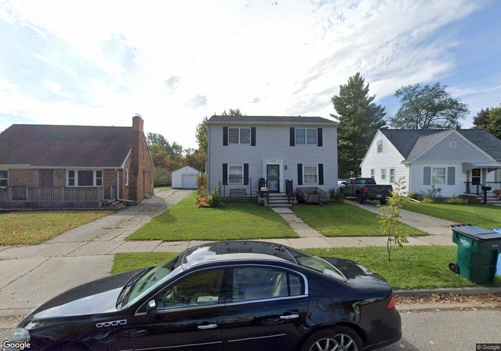
1705 Lenore Ave Lansing, MI 48910
Colonial Village NeighborhoodEstimated Value: $174,000 - $232,000
Studio
--
Bath
1,792
Sq Ft
$111/Sq Ft
Est. Value
About This Home
This home is located at 1705 Lenore Ave, Lansing, MI 48910 and is currently estimated at $199,686, approximately $111 per square foot. 1705 Lenore Ave is a home located in Ingham County with nearby schools including Averill Elementary School, Attwood School, and J.W. Sexton High School.
Ownership History
Date
Name
Owned For
Owner Type
Purchase Details
Closed on
Apr 28, 2014
Sold by
Skiffington Ronald H and Skiffington Therese M
Bought by
Skiffington Ronald H and Skiffington Therese M
Current Estimated Value
Create a Home Valuation Report for This Property
The Home Valuation Report is an in-depth analysis detailing your home's value as well as a comparison with similar homes in the area
Home Values in the Area
Average Home Value in this Area
Purchase History
| Date | Buyer | Sale Price | Title Company |
|---|---|---|---|
| Skiffington Ronald H | -- | None Available |
Source: Public Records
Tax History
| Year | Tax Paid | Tax Assessment Tax Assessment Total Assessment is a certain percentage of the fair market value that is determined by local assessors to be the total taxable value of land and additions on the property. | Land | Improvement |
|---|---|---|---|---|
| 2025 | $4,003 | $96,800 | $9,800 | $87,000 |
| 2024 | $32 | $89,100 | $9,800 | $79,300 |
| 2023 | $3,752 | $82,300 | $9,800 | $72,500 |
| 2022 | $3,380 | $79,300 | $9,200 | $70,100 |
| 2021 | $3,200 | $72,500 | $6,300 | $66,200 |
| 2020 | $3,181 | $67,200 | $6,300 | $60,900 |
| 2019 | $3,051 | $64,500 | $6,300 | $58,200 |
| 2018 | $2,857 | $56,000 | $6,300 | $49,700 |
| 2017 | $2,736 | $56,000 | $6,300 | $49,700 |
| 2016 | $2,616 | $50,100 | $6,300 | $43,800 |
| 2015 | $2,616 | $48,400 | $12,681 | $35,719 |
| 2014 | $2,616 | $47,400 | $9,511 | $37,889 |
Source: Public Records
Map
Nearby Homes
- 1534 Lenore Ave
- 1517 Lenore Ave
- 1323 Cooper Ave
- 1740 Wellington Rd Unit 103
- 1618 Loraine Ave
- 1312 W Mount Hope Ave
- 2505 Fairfax Rd
- 2519 Marion Ave
- 1114 Goodrich St
- 2001 S Martin Luther King Junior Blvd
- 1116 George St
- 1309 Hammond St
- 1511 Pattengill Ave
- 1017 W Barnes Ave
- 900 W Mount Hope Ave
- 2421 Stirling Ave
- 3125 Boston Blvd
- 815 Woodbine Ave
- 1120 Alsdorf St
- 815 Smith Ave
- 1701 Lenore Ave
- 1709 Lenore Ave
- 1623 Lenore Ave
- 1715 Lenore Ave
- 1700 Cooper Ave
- 1704 Cooper Ave
- 1630 Cooper Ave
- 1710 Cooper Ave
- 1626 Cooper Ave
- 1714 Cooper Ave
- 1721 Lenore Ave
- 1622 Cooper Ave
- 1700 Lenore Ave
- 1718 Cooper Ave
- 1708 Lenore Ave
- 2107 Boston Blvd
- 2111 Boston Blvd
- 1714 Lenore Ave
- 1618 Cooper Ave
Your Personal Tour Guide
Ask me questions while you tour the home.