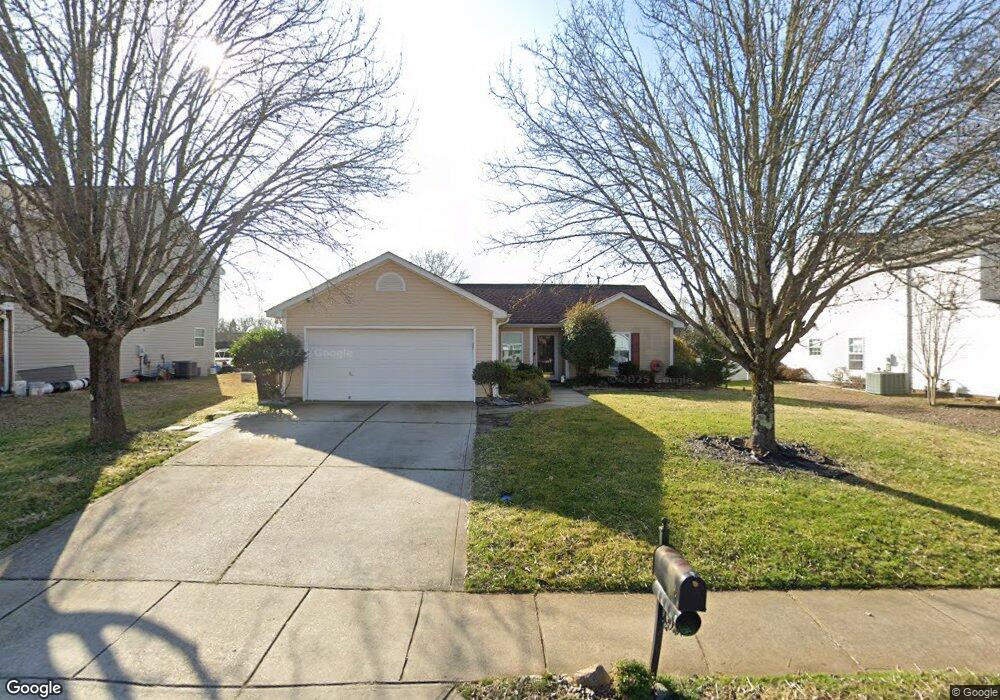
1707 Hardy Dr Rock Hill, SC 29732
Estimated Value: $289,849 - $305,000
3
Beds
2
Baths
1,190
Sq Ft
$251/Sq Ft
Est. Value
About This Home
This home is located at 1707 Hardy Dr, Rock Hill, SC 29732 and is currently estimated at $298,712, approximately $251 per square foot. 1707 Hardy Dr is a home located in York County with nearby schools including Dutchman Creek Middle School, Rock Hill High School, and St. Anne Catholic School.
Ownership History
Date
Name
Owned For
Owner Type
Purchase Details
Closed on
Apr 20, 2011
Sold by
Southern Breeze Investments Llc
Bought by
Rivers Robert and Rivers Evelyn
Current Estimated Value
Purchase Details
Closed on
Aug 25, 2010
Sold by
Federal Home Loan Mortgage Corporation
Bought by
Southern Breeze Investments Llc
Purchase Details
Closed on
Mar 19, 2010
Sold by
Lagodkin Peter and Lagodkin Theresa
Bought by
Federal Home Loan Mortgage Corp
Purchase Details
Closed on
Mar 27, 2001
Sold by
Crossmann Communities Of Nc Inc
Bought by
Lagodkin Peter and Lagodkin Theresa
Create a Home Valuation Report for This Property
The Home Valuation Report is an in-depth analysis detailing your home's value as well as a comparison with similar homes in the area
Home Values in the Area
Average Home Value in this Area
Purchase History
| Date | Buyer | Sale Price | Title Company |
|---|---|---|---|
| Rivers Robert | $103,500 | -- | |
| Southern Breeze Investments Llc | $85,000 | -- | |
| Federal Home Loan Mortgage Corp | $121,941 | -- | |
| Lagodkin Peter | $105,110 | -- |
Source: Public Records
Tax History Compared to Growth
Tax History
| Year | Tax Paid | Tax Assessment Tax Assessment Total Assessment is a certain percentage of the fair market value that is determined by local assessors to be the total taxable value of land and additions on the property. | Land | Improvement |
|---|---|---|---|---|
| 2024 | $586 | $4,669 | $1,060 | $3,609 |
| 2023 | $587 | $4,669 | $1,060 | $3,609 |
| 2022 | $591 | $4,669 | $1,060 | $3,609 |
| 2021 | -- | $4,669 | $1,060 | $3,609 |
| 2020 | $593 | $4,669 | $0 | $0 |
| 2019 | $472 | $4,060 | $0 | $0 |
| 2018 | $471 | $4,060 | $0 | $0 |
| 2017 | $454 | $4,060 | $0 | $0 |
| 2016 | $450 | $4,060 | $0 | $0 |
| 2014 | $957 | $3,960 | $1,000 | $2,960 |
| 2013 | $957 | $4,600 | $1,120 | $3,480 |
Source: Public Records
Map
Nearby Homes
- 1684 Tate Rd Unit 273
- 1620 Tate Rd
- 1747 Baylor Dr
- 1614 Hardy Dr
- 1776 Rosewell Dr
- 1791 Rosewell Dr Unit 65
- 1944 Bristol Pkwy
- 1352 Walnut Hill Dr
- 2225 Mount Gallant Rd
- 1554 Maypine Commons Way
- 1542 Maypine Commons Way
- 1729 Fieldcrest Cir
- 2065 Hightower Rd
- 2177 Lookout Ridge
- 5119 Norway Ln
- 2016 Celanese Rd
- 2296 Blue Ridge Way
- Acreage Mount Gallant Rd
- 2300 Crosstrail Ridge
- 2229 Rosewood Dr