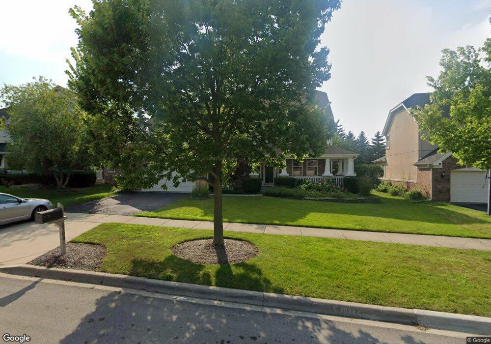
1708 Saint Andrew Dr Vernon Hills, IL 60061
Gregg's Landing NeighborhoodEstimated Value: $750,000 - $794,000
--
Bed
3
Baths
3,016
Sq Ft
$255/Sq Ft
Est. Value
About This Home
This home is located at 1708 Saint Andrew Dr, Vernon Hills, IL 60061 and is currently estimated at $768,597, approximately $254 per square foot. 1708 Saint Andrew Dr is a home located in Lake County with nearby schools including Hawthorn Elementary School North, Hawthorn School Of Dual Language, and Hawthorn Middle School North.
Ownership History
Date
Name
Owned For
Owner Type
Purchase Details
Closed on
Dec 2, 2009
Sold by
Mayes Richard A and Mayes Erin E
Bought by
Mayes Erin E and Erin E Mayes 2001 Living Trust
Current Estimated Value
Purchase Details
Closed on
Apr 18, 2001
Sold by
Centex Homes
Bought by
Mayes Richard A and Mayes Erin E
Home Financials for this Owner
Home Financials are based on the most recent Mortgage that was taken out on this home.
Original Mortgage
$275,000
Interest Rate
7.23%
Create a Home Valuation Report for This Property
The Home Valuation Report is an in-depth analysis detailing your home's value as well as a comparison with similar homes in the area
Home Values in the Area
Average Home Value in this Area
Purchase History
| Date | Buyer | Sale Price | Title Company |
|---|---|---|---|
| Mayes Erin E | -- | None Available | |
| Mayes Richard A | $403,500 | -- |
Source: Public Records
Mortgage History
| Date | Status | Borrower | Loan Amount |
|---|---|---|---|
| Previous Owner | Mayes Richard A | $275,000 |
Source: Public Records
Tax History Compared to Growth
Tax History
| Year | Tax Paid | Tax Assessment Tax Assessment Total Assessment is a certain percentage of the fair market value that is determined by local assessors to be the total taxable value of land and additions on the property. | Land | Improvement |
|---|---|---|---|---|
| 2024 | $16,137 | $195,924 | $46,057 | $149,867 |
| 2023 | $16,137 | $180,708 | $42,480 | $138,228 |
| 2022 | $16,137 | $178,873 | $40,830 | $138,043 |
| 2021 | $15,447 | $175,022 | $39,951 | $135,071 |
| 2020 | $14,891 | $172,079 | $39,279 | $132,800 |
| 2019 | $14,514 | $170,443 | $38,906 | $131,537 |
| 2018 | $14,337 | $193,922 | $45,095 | $148,827 |
| 2017 | $16,060 | $187,799 | $43,671 | $144,128 |
| 2016 | $15,419 | $178,059 | $41,406 | $136,653 |
| 2015 | $14,939 | $163,588 | $38,701 | $124,887 |
| 2014 | $14,843 | $158,851 | $38,182 | $120,669 |
| 2012 | $14,251 | $160,229 | $38,513 | $121,716 |
Source: Public Records
Map
Nearby Homes
- 1688 Saint Andrew Dr
- 1726 Shoal Creek Terrace
- 1290 Butterfield Rd
- 1255 Huntington Dr
- 1654 Pebble Beach Way
- 900 S Butterfield Rd
- 31 Washington Blvd Unit 108
- 608 Sycamore St
- 422 Shadow Creek Dr
- 1969 Royal Birkdale Dr
- 640 Allanson Rd
- 20 Echo Ct Unit 3
- 2245 Hazeltime Dr
- 49 N Shaddle Ave
- 11 Echo Ct Unit 12
- 15 Echo Ct Unit 8
- 4 Parkside Ct Unit 12
- 701 Thomas Ct
- 1939 Lake Charles Dr
- 1933 Lake Charles Dr
- 1716 Saint Andrew Dr
- 1700 Saint Andrew Dr
- 1700 Saint Andrew Dr
- 1724 Saint Andrew Dr
- 1698 Saint Andrew Dr
- 1703 Saint Andrew Dr
- 1709 Saint Andrew Dr
- 1717 Saint Andrew Dr
- 1696 Saint Andrew Dr
- 1732 Saint Andrew Dr
- 1699 St Andrew Dr
- 1699 Saint Andrew Dr
- 1725 Saint Andrew Dr
- 1740 Saint Andrew Dr
- 1694 Saint Andrew Dr
- 1691 Saint Andrew Dr
- 1706 Locke Ln
- 1733 Saint Andrew Dr
- 400 S Butterfield Rd
- 1698 Locke Ln