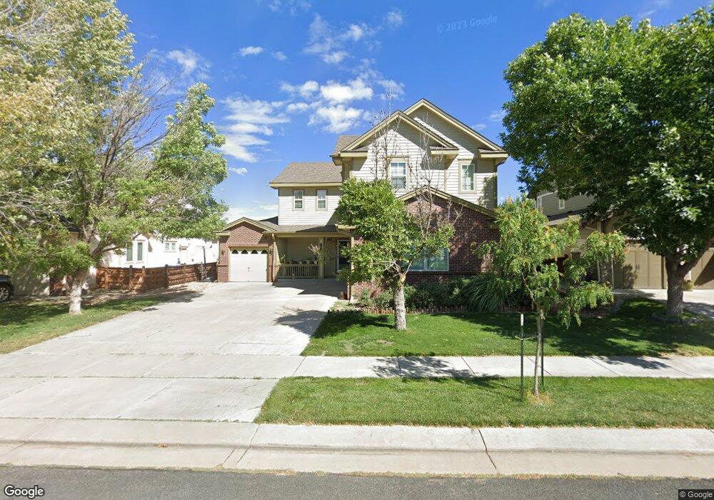
17089 E 106th Way Commerce City, CO 80022
Reunion NeighborhoodEstimated Value: $528,000 - $608,000
3
Beds
3
Baths
3,408
Sq Ft
$164/Sq Ft
Est. Value
About This Home
This home is located at 17089 E 106th Way, Commerce City, CO 80022 and is currently estimated at $560,315, approximately $164 per square foot. 17089 E 106th Way is a home located in Adams County with nearby schools including Reunion Elementary School, Otho E Stuart Middle School, and Prairie View High School.
Ownership History
Date
Name
Owned For
Owner Type
Purchase Details
Closed on
Sep 29, 2016
Sold by
Mongrain Darin R
Bought by
Retecki Stephaine and Retecki Jakub
Current Estimated Value
Home Financials for this Owner
Home Financials are based on the most recent Mortgage that was taken out on this home.
Original Mortgage
$234,500
Outstanding Balance
$187,817
Interest Rate
3.43%
Mortgage Type
New Conventional
Estimated Equity
$372,498
Purchase Details
Closed on
Sep 23, 2005
Sold by
Lennar Colorado Llc
Bought by
Mongrain Darin R and Mongrain Theresa A
Home Financials for this Owner
Home Financials are based on the most recent Mortgage that was taken out on this home.
Original Mortgage
$218,400
Interest Rate
7%
Mortgage Type
Unknown
Create a Home Valuation Report for This Property
The Home Valuation Report is an in-depth analysis detailing your home's value as well as a comparison with similar homes in the area
Home Values in the Area
Average Home Value in this Area
Purchase History
| Date | Buyer | Sale Price | Title Company |
|---|---|---|---|
| Retecki Stephaine | $350,500 | Land Title Guarantee Co | |
| Mongrain Darin R | $273,000 | North American Title |
Source: Public Records
Mortgage History
| Date | Status | Borrower | Loan Amount |
|---|---|---|---|
| Open | Retecki Stephaine | $234,500 | |
| Previous Owner | Mongrain Darin R | $218,400 |
Source: Public Records
Tax History Compared to Growth
Tax History
| Year | Tax Paid | Tax Assessment Tax Assessment Total Assessment is a certain percentage of the fair market value that is determined by local assessors to be the total taxable value of land and additions on the property. | Land | Improvement |
|---|---|---|---|---|
| 2024 | $7,485 | $34,000 | $7,500 | $26,500 |
| 2023 | $7,461 | $39,030 | $7,440 | $31,590 |
| 2022 | $6,659 | $30,190 | $7,650 | $22,540 |
| 2021 | $6,519 | $30,190 | $7,650 | $22,540 |
| 2020 | $6,046 | $28,920 | $7,870 | $21,050 |
| 2019 | $6,045 | $28,920 | $7,870 | $21,050 |
| 2018 | $5,867 | $27,100 | $7,200 | $19,900 |
| 2017 | $5,729 | $27,100 | $7,200 | $19,900 |
| 2016 | $4,548 | $22,330 | $5,170 | $17,160 |
| 2015 | $4,546 | $22,330 | $5,170 | $17,160 |
| 2014 | $3,924 | $19,410 | $4,300 | $15,110 |
Source: Public Records
Map
Nearby Homes
- 17045 E 105th Ave
- 10505 Richfield St
- 10609 Ouray Ct
- 10550 Sedalia St
- 17070 E 104th Place
- 16743 Parkside Dr S
- 17310 E 104th Place
- 16650 E 107th Ct
- 16673 Parkside Dr S
- 16724 E 105th Ave
- 10440 Olathe St
- 17741 Parkside Dr N
- 17439 E 103rd Place
- 10680 Norfolk St
- Landau Plan at Reunion Ridge - Coach House
- Albright Plan at Reunion Ridge - American Dream
- Rand Plan at Reunion Ridge - American Dream
- Haflinger Plan at Reunion Ridge - Coach House
- Dalton Plan at Reunion Ridge - Porchlight
- Muir Plan at Reunion Ridge - American Dream
- 17079 E 106th Way
- 17099 E 106th Way
- 17080 E 107th Ave
- 17070 E 107th Ave
- 17069 E 106th Way
- 17090 E 107th Ave
- 17060 E 107th Ave
- 17098 E 106th Way
- 17078 E 106th Way
- 17050 E 107th Ave
- 17059 E 106th Way
- 32920 E 88th Ave
- 33162 E 88th Ave
- 17068 E 106th Way
- 17040 E 107th Ave
- 17049 E 106th Way
- 17058 E 106th Way
- 17097 E 106th Ave
- 10599 Quintero St
- 17061 E 107th Ave