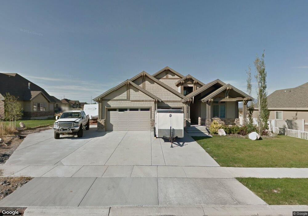
1709 Gunstock Dr Riverton, UT 84065
Estimated Value: $624,000 - $846,000
2
Beds
2
Baths
2,165
Sq Ft
$356/Sq Ft
Est. Value
About This Home
This home is located at 1709 Gunstock Dr, Riverton, UT 84065 and is currently estimated at $771,118, approximately $356 per square foot. 1709 Gunstock Dr is a home located in Salt Lake County with nearby schools including Mountain Point Elementary School, Hidden Valley Middle School, and Riverton High School.
Ownership History
Date
Name
Owned For
Owner Type
Purchase Details
Closed on
Dec 16, 2020
Sold by
Farnworth Jay L and Farnworth Janet
Bought by
Farnworth Jay Lee and Farnworth Janet Lee
Current Estimated Value
Purchase Details
Closed on
Sep 26, 2012
Sold by
Mountain Vista Development Inc
Bought by
Farnworth Jay L and Farnworth Janet
Home Financials for this Owner
Home Financials are based on the most recent Mortgage that was taken out on this home.
Original Mortgage
$316,658
Outstanding Balance
$220,408
Interest Rate
3.62%
Mortgage Type
FHA
Estimated Equity
$550,710
Purchase Details
Closed on
Jan 6, 2006
Sold by
Simpack Llc
Bought by
Mountain Vista Development Inc
Home Financials for this Owner
Home Financials are based on the most recent Mortgage that was taken out on this home.
Original Mortgage
$348,750
Interest Rate
6.27%
Mortgage Type
Construction
Create a Home Valuation Report for This Property
The Home Valuation Report is an in-depth analysis detailing your home's value as well as a comparison with similar homes in the area
Home Values in the Area
Average Home Value in this Area
Purchase History
| Date | Buyer | Sale Price | Title Company |
|---|---|---|---|
| Farnworth Jay Lee | -- | Eagle Pointe Title | |
| Farnworth Jay L | -- | Sutherland Title | |
| Mountain Vista Development Inc | -- | Summit Escrow & Title | |
| Simpack Llc | -- | Summit Escrow & Title |
Source: Public Records
Mortgage History
| Date | Status | Borrower | Loan Amount |
|---|---|---|---|
| Open | Farnworth Jay L | $316,658 | |
| Previous Owner | Simpack Llc | $348,750 |
Source: Public Records
Tax History Compared to Growth
Tax History
| Year | Tax Paid | Tax Assessment Tax Assessment Total Assessment is a certain percentage of the fair market value that is determined by local assessors to be the total taxable value of land and additions on the property. | Land | Improvement |
|---|---|---|---|---|
| 2025 | $3,577 | $773,400 | $271,300 | $502,100 |
| 2024 | $3,577 | $732,800 | $257,500 | $475,300 |
| 2023 | $3,971 | $724,900 | $250,100 | $474,800 |
| 2022 | $3,984 | $694,300 | $245,200 | $449,100 |
| 2021 | $3,264 | $530,900 | $202,500 | $328,400 |
| 2020 | $3,130 | $474,300 | $154,600 | $319,700 |
| 2019 | $3,145 | $467,500 | $154,600 | $312,900 |
| 2018 | $2,858 | $437,700 | $150,300 | $287,400 |
| 2017 | $2,710 | $397,000 | $150,300 | $246,700 |
| 2016 | $2,612 | $379,200 | $106,400 | $272,800 |
| 2015 | $2,160 | $305,400 | $111,400 | $194,000 |
| 2014 | $2,402 | $333,900 | $123,500 | $210,400 |
Source: Public Records
Map
Nearby Homes
- 1812 Crooked Sky Dr
- 12783 Aspen Trail Dr
- 16132 S Coupler Ln Unit 406
- 15880 S Rockwell Park Ln
- 16158 S Railcar Ln Unit 1031
- 1452 W Meadow Glen Dr
- 15541 S Democracy Dr
- 15524 S Trumpet Ln
- 15261 S Reins Way
- 1890 W Rock Hollow Rd
- 15190 S Wild Horse Way
- 15506 S Midnight View Way
- 15152 S Wild Horse Way
- 16436 S Bull Spring Ln
- 15124 S Wild Horse Way
- 1586 W Rock Hollow Dr
- 15461 S Midnight View Way
- 15129 S Halter Way
- 15084 S Wild Horse Way
- 15135 S Reins Way Unit 680
- 1709 W Gunstock Dr S
- 1693 W Gunstock Dr S
- 1723 W Gunstock Dr S
- 1693 Gunstock Dr
- 1723 Gunstock Dr
- 1726 W Gun Stock Dr
- 15733 Gun Stock Dr Unit 147
- 1696 River View Dr
- 1696 W River View Dr
- 1725 W River View Dr
- 1712 W Gunstock Dr S
- 1712 Gun Stock Dr
- 1712 Gunstock Dr
- 1694 W Gunstock Dr W Unit 159
- 1694 W Gunstock Dr S
- 1694 W Gunstock Dr W
- 1694 Gun Stock Dr
- 15733 S Gunstock Dr
- 1694 Gunstock Dr
- 1677 W Gunstock Dr