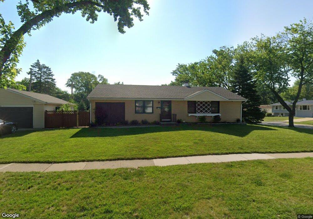
171 Cherrywood Rd Buffalo Grove, IL 60089
South Buffalo Grove NeighborhoodEstimated Value: $389,000 - $434,000
3
Beds
1
Bath
1,343
Sq Ft
$302/Sq Ft
Est. Value
About This Home
This home is located at 171 Cherrywood Rd, Buffalo Grove, IL 60089 and is currently estimated at $405,071, approximately $301 per square foot. 171 Cherrywood Rd is a home located in Cook County with nearby schools including Henry W Longfellow Elementary School, Cooper Middle School, and Buffalo Grove High School.
Ownership History
Date
Name
Owned For
Owner Type
Purchase Details
Closed on
Jul 2, 2009
Sold by
Allendorf Lawrence
Bought by
Soderberg Jamie and Chopin Maria
Current Estimated Value
Home Financials for this Owner
Home Financials are based on the most recent Mortgage that was taken out on this home.
Original Mortgage
$215,040
Interest Rate
5.29%
Mortgage Type
VA
Create a Home Valuation Report for This Property
The Home Valuation Report is an in-depth analysis detailing your home's value as well as a comparison with similar homes in the area
Home Values in the Area
Average Home Value in this Area
Purchase History
| Date | Buyer | Sale Price | Title Company |
|---|---|---|---|
| Soderberg Jamie | $210,000 | Cti |
Source: Public Records
Mortgage History
| Date | Status | Borrower | Loan Amount |
|---|---|---|---|
| Previous Owner | Soderberg Jamie | $215,040 |
Source: Public Records
Tax History Compared to Growth
Tax History
| Year | Tax Paid | Tax Assessment Tax Assessment Total Assessment is a certain percentage of the fair market value that is determined by local assessors to be the total taxable value of land and additions on the property. | Land | Improvement |
|---|---|---|---|---|
| 2024 | $8,220 | $29,000 | $7,571 | $21,429 |
| 2023 | $7,876 | $29,000 | $7,571 | $21,429 |
| 2022 | $7,876 | $29,000 | $7,571 | $21,429 |
| 2021 | $7,313 | $24,029 | $4,836 | $19,193 |
| 2020 | $7,195 | $24,029 | $4,836 | $19,193 |
| 2019 | $7,186 | $26,640 | $4,836 | $21,804 |
| 2018 | $7,851 | $26,232 | $4,206 | $22,026 |
| 2017 | $7,727 | $26,232 | $4,206 | $22,026 |
| 2016 | $7,454 | $26,232 | $4,206 | $22,026 |
| 2015 | $6,887 | $22,894 | $3,575 | $19,319 |
| 2014 | $6,791 | $22,894 | $3,575 | $19,319 |
| 2013 | $6,259 | $22,894 | $3,575 | $19,319 |
Source: Public Records
Map
Nearby Homes
- 98 Stonegate Rd
- 410 Chatham Cir
- 310 Rosewood Ave
- 921 Bernard Dr
- 408 Indian Hill Dr
- 455 Mayfair Ln
- 535 Estate Dr
- 746 Old Checker Rd Unit E5
- 25 Crestview Terrace
- 476 Raupp Blvd
- 872 Old Checker Rd Unit E3
- 859 Beechwood Rd
- 665 Thornwood Dr
- 1112 Auburn Ln
- 183 Saint Marys Pkwy
- 813 Stradford Cir Unit 21B2
- 234 Mohawk Trail
- 820 Weidner Rd Unit 4013
- 820 Weidner Rd Unit 409
- 98 Glendale Rd
- 692 Maple Dr
- 151 Cherrywood Rd
- 684 Maple Dr
- 691 Saint Marys Pkwy
- 170 Cherrywood Rd
- 180 Cherrywood Rd
- 162 Cherrywood Rd
- 683 Saint Marys Pkwy
- 199 Cherrywood Rd
- 190 Cherrywood Rd
- 674 Maple Dr
- 691 Maple Dr
- 731 Saint Marys Pkwy
- 685 Maple Dr
- 200 Cherrywood Rd
- 673 Saint Marys Pkwy Unit 6
- 662 Maple Dr
- 673 Maple Dr
- 210 Cherrywood Rd
- 175 Belaire Dr