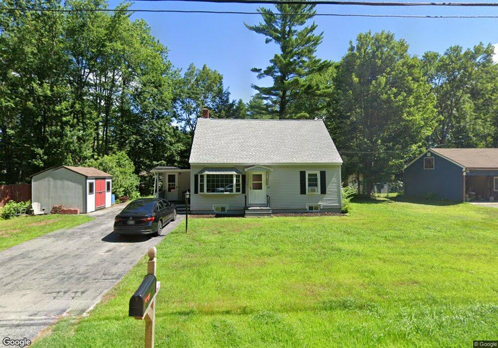
171 Garfield Rd Auburn, ME 04210
Estimated Value: $286,000 - $321,000
4
Beds
2
Baths
1,080
Sq Ft
$282/Sq Ft
Est. Value
About This Home
This home is located at 171 Garfield Rd, Auburn, ME 04210 and is currently estimated at $304,376, approximately $281 per square foot. 171 Garfield Rd is a home located in Androscoggin County with nearby schools including Fairview School, Auburn Middle School, and Edward Little High School.
Ownership History
Date
Name
Owned For
Owner Type
Purchase Details
Closed on
Jul 17, 2024
Sold by
Bisson Kathleen M and Spugnardi Christina L
Bought by
Perron Noah J
Current Estimated Value
Home Financials for this Owner
Home Financials are based on the most recent Mortgage that was taken out on this home.
Original Mortgage
$240,000
Outstanding Balance
$237,133
Interest Rate
6.99%
Mortgage Type
Purchase Money Mortgage
Estimated Equity
$67,243
Create a Home Valuation Report for This Property
The Home Valuation Report is an in-depth analysis detailing your home's value as well as a comparison with similar homes in the area
Home Values in the Area
Average Home Value in this Area
Purchase History
| Date | Buyer | Sale Price | Title Company |
|---|---|---|---|
| Perron Noah J | $300,000 | None Available | |
| Perron Noah J | $300,000 | None Available |
Source: Public Records
Mortgage History
| Date | Status | Borrower | Loan Amount |
|---|---|---|---|
| Open | Perron Noah J | $240,000 | |
| Closed | Perron Noah J | $240,000 |
Source: Public Records
Tax History Compared to Growth
Tax History
| Year | Tax Paid | Tax Assessment Tax Assessment Total Assessment is a certain percentage of the fair market value that is determined by local assessors to be the total taxable value of land and additions on the property. | Land | Improvement |
|---|---|---|---|---|
| 2024 | $3,860 | $173,500 | $42,200 | $131,300 |
| 2023 | $3,510 | $154,300 | $37,500 | $116,800 |
| 2022 | $3,510 | $154,300 | $37,500 | $116,800 |
| 2021 | $3,063 | $128,600 | $31,200 | $97,400 |
| 2020 | $3,054 | $128,600 | $31,200 | $97,400 |
| 2019 | $3,054 | $128,600 | $31,200 | $97,400 |
| 2018 | $3,045 | $128,600 | $31,200 | $97,400 |
| 2017 | $2,957 | $128,600 | $31,200 | $97,400 |
| 2016 | $2,874 | $128,600 | $31,200 | $97,400 |
| 2015 | $2,733 | $128,600 | $31,200 | $97,400 |
| 2013 | $2,635 | $129,000 | $31,200 | $97,800 |
Source: Public Records
Map
Nearby Homes
- 521 Stevens Mill Rd
- lot 11 Minot Ave
- 65 Cedarwood Rd
- 880 Minot Ave
- 867 Minot Ave
- 863 Minot Ave
- 350 Merrow Rd
- 151 Allen Ave
- 34 Pride Rd
- 69 Dawes Ave
- 15 Dunham St
- 89 Pride Rd
- 20 Towle Ave
- 88 Cove Rd
- 62 Fletcher Rd
- 72 Amberley Way
- 46 Club House Ln Unit 9
- 112 Poland Rd
- 36 Colonial Way Unit 36
- 206 Fairview Ave
- 163 Garfield Rd
- 560 Stevens Mill Rd
- 544 Stevens Mill Rd
- 575 Stevens Mill Rd
- 289 Sunderland Dr
- 534 Stevens Mill Rd
- 143 Garfield Rd
- 284 Sunderland Dr
- 193 Garfield Rd
- 20 Anita Ave
- 267 Sunderland Dr
- 260 Sunderland Dr
- 535 Stevens Mill Rd
- 211 Garfield Rd
- 131 Garfield Rd
- 236 Sunderland Dr
- 263 Sunderland Dr
- 504 Stevens Mill Rd
- 255 Sunderland Dr
- 125 Garfield Rd