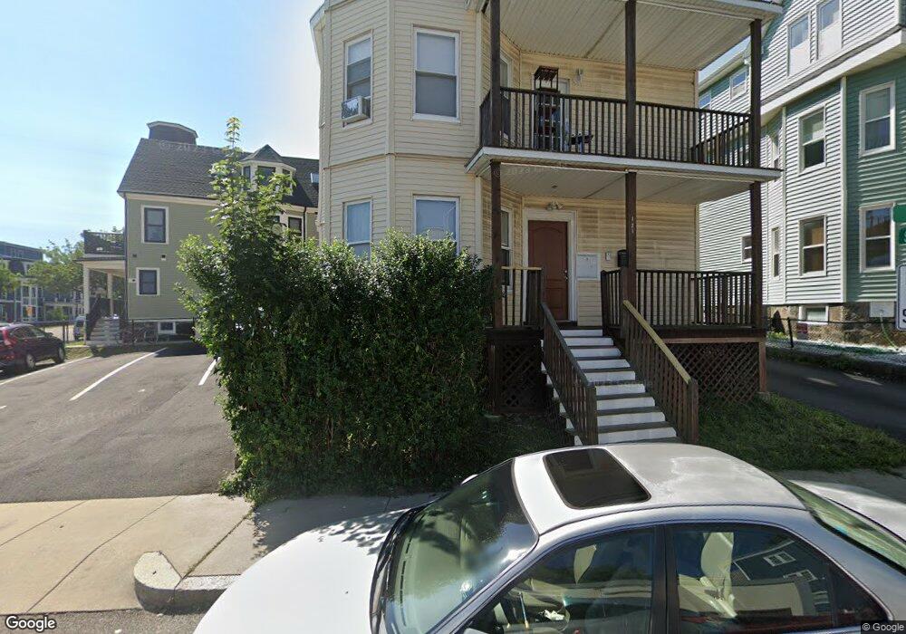
171 King St Dorchester, MA 02122
Neponset-Port Norfolk NeighborhoodEstimated Value: $1,236,503
8
Beds
3
Baths
3,480
Sq Ft
$355/Sq Ft
Est. Value
About This Home
This home is located at 171 King St, Dorchester, MA 02122 and is currently estimated at $1,236,503, approximately $355 per square foot. 171 King St is a home located in Suffolk County with nearby schools including Neighborhood House Charter School and Helen Y. Davis Leadership Academy Charter Public School.
Ownership History
Date
Name
Owned For
Owner Type
Purchase Details
Closed on
Dec 23, 2005
Sold by
Fields James D and Fields Lindsa
Bought by
Scott M David
Current Estimated Value
Home Financials for this Owner
Home Financials are based on the most recent Mortgage that was taken out on this home.
Original Mortgage
$464,000
Outstanding Balance
$260,690
Interest Rate
6.36%
Mortgage Type
Purchase Money Mortgage
Estimated Equity
$975,813
Purchase Details
Closed on
Oct 31, 2003
Sold by
Flaherty Michelle M and Flaherty Paul F
Bought by
Fields Lindsa and Fields James D
Home Financials for this Owner
Home Financials are based on the most recent Mortgage that was taken out on this home.
Original Mortgage
$428,000
Interest Rate
6.05%
Mortgage Type
Purchase Money Mortgage
Purchase Details
Closed on
Oct 8, 1999
Sold by
Purshotham Jasmine
Bought by
Mullen Michelle
Create a Home Valuation Report for This Property
The Home Valuation Report is an in-depth analysis detailing your home's value as well as a comparison with similar homes in the area
Home Values in the Area
Average Home Value in this Area
Purchase History
| Date | Buyer | Sale Price | Title Company |
|---|---|---|---|
| Scott M David | $580,000 | -- | |
| Fields Lindsa | $535,000 | -- | |
| Mullen Michelle | $215,000 | -- |
Source: Public Records
Mortgage History
| Date | Status | Borrower | Loan Amount |
|---|---|---|---|
| Open | Scott M David | $464,000 | |
| Previous Owner | Mullen Michelle | $428,000 | |
| Previous Owner | Mullen Michelle | $80,250 |
Source: Public Records
Tax History Compared to Growth
Tax History
| Year | Tax Paid | Tax Assessment Tax Assessment Total Assessment is a certain percentage of the fair market value that is determined by local assessors to be the total taxable value of land and additions on the property. | Land | Improvement |
|---|---|---|---|---|
| 2025 | -- | $0 | $0 | $0 |
| 2024 | -- | $0 | $0 | $0 |
| 2023 | $0 | $0 | $0 | $0 |
| 2022 | $0 | $0 | $0 | $0 |
| 2021 | $0 | $0 | $0 | $0 |
| 2020 | $0 | $0 | $0 | $0 |
| 2019 | $0 | $0 | $0 | $0 |
| 2018 | $0 | $0 | $0 | $0 |
| 2017 | $0 | $0 | $0 | $0 |
| 2016 | -- | $0 | $0 | $0 |
| 2015 | -- | $0 | $0 | $0 |
| 2014 | -- | $0 | $0 | $0 |
Source: Public Records
Map
Nearby Homes
- 108 King St Unit 3
- 104 King St Unit 2
- 6 Agawam St
- 96 King St Unit 1
- 34 Houghton St
- 60 Houghton St Unit 62
- 3 N Munroe Terrace
- 4 Payne St Unit 5
- 381 Adams St Unit 2
- 381 Adams St Unit 1
- 381 Adams St Unit 3
- 382 Adams St Unit 384-1
- 20 Leslie St
- 223 Neponset Ave Unit 2
- 41 King St Unit 1
- 334 Centre St Unit 101
- 334 Centre St Unit 2
- 543 Adams St Unit 24
- 17 Lafield St Unit 2
- 34 Dix St Unit 3
- 171 King St Unit 3
- 171 King St Unit 2
- 171 King St Unit 1
- 167 King St Unit 3
- 167 King St Unit 2
- 167 King St Unit 1
- 125 Neponset Ave
- 125 Neponset Ave Unit 3
- 125 Neponset Ave Unit 2
- 125 Neponset Ave Unit 1
- 117 Neponset Ave
- 119 Neponset Ave
- 163 King St
- 132 King St Unit 3
- 132 King St Unit 2
- 132 King St Unit 1
- 132 King St
- 129 Neponset Ave Unit 9
- 129 Neponset Ave Unit 8
- 129 Neponset Ave Unit 7