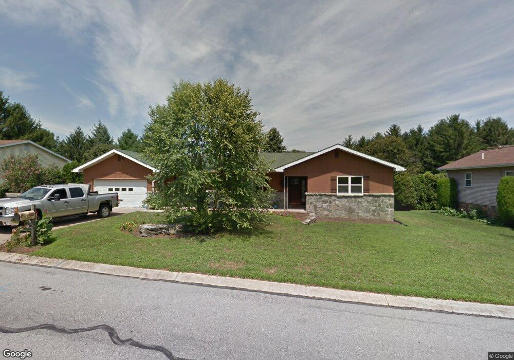
171 Lamp Post Ln Hershey, PA 17033
Estimated Value: $384,647 - $555,000
3
Beds
1
Bath
2,340
Sq Ft
$198/Sq Ft
Est. Value
About This Home
This home is located at 171 Lamp Post Ln, Hershey, PA 17033 and is currently estimated at $463,912, approximately $198 per square foot. 171 Lamp Post Ln is a home located in Dauphin County with nearby schools including Hershey Elementary School, Hershey Primary Elementary School, and Hershey Middle School.
Ownership History
Date
Name
Owned For
Owner Type
Purchase Details
Closed on
May 7, 2011
Sold by
Wagner John K
Bought by
Bye Jeffrey R
Current Estimated Value
Home Financials for this Owner
Home Financials are based on the most recent Mortgage that was taken out on this home.
Original Mortgage
$168,000
Outstanding Balance
$116,752
Interest Rate
4.88%
Mortgage Type
New Conventional
Estimated Equity
$347,160
Create a Home Valuation Report for This Property
The Home Valuation Report is an in-depth analysis detailing your home's value as well as a comparison with similar homes in the area
Home Values in the Area
Average Home Value in this Area
Purchase History
| Date | Buyer | Sale Price | Title Company |
|---|---|---|---|
| Bye Jeffrey R | $210,000 | -- |
Source: Public Records
Mortgage History
| Date | Status | Borrower | Loan Amount |
|---|---|---|---|
| Open | Bye Jeffrey R | $168,000 |
Source: Public Records
Tax History
| Year | Tax Paid | Tax Assessment Tax Assessment Total Assessment is a certain percentage of the fair market value that is determined by local assessors to be the total taxable value of land and additions on the property. | Land | Improvement |
|---|---|---|---|---|
| 2025 | $4,235 | $135,500 | $3,600 | $131,900 |
| 2024 | $3,980 | $135,500 | $3,600 | $131,900 |
| 2023 | $3,909 | $135,500 | $3,600 | $131,900 |
| 2022 | $3,822 | $135,500 | $3,600 | $131,900 |
| 2021 | $3,822 | $135,500 | $3,600 | $131,900 |
| 2020 | $3,822 | $135,500 | $3,600 | $131,900 |
| 2019 | $3,753 | $135,500 | $3,600 | $131,900 |
| 2018 | $3,654 | $135,500 | $3,600 | $131,900 |
| 2017 | $3,654 | $135,500 | $3,600 | $131,900 |
| 2016 | $0 | $135,500 | $3,600 | $131,900 |
| 2015 | -- | $135,500 | $3,600 | $131,900 |
| 2014 | -- | $135,500 | $3,600 | $131,900 |
Source: Public Records
Map
Nearby Homes
- 0 Stauffers Church Rd Unit PADA2052308
- 2 Plymouth Cir
- 214 William Dr
- 1343 Church Rd
- 222 Robin Rd
- 33 Sterling Ct
- 24 Glasgow Ct
- 81 Cambridge Dr
- 104 Cambridge Dr
- 0 Hill Church Rd
- 555 Hilltop Rd
- 29 Almond Dr
- 46 W Governor Rd
- 15 W Governor Rd
- 115 S Hills Dr
- 0 Sand Hill Rd
- 81 Locust Ave
- 420 Cedar Ave
- 251 Maple Ave
- 519 Cedar Ave
- 161 Lamp Post Ln
- 181 Lamp Post Ln
- 164 Lamp Post Ln
- 166 Lamp Post Ln
- 174 Lamp Post Ln
- 156 Lamp Post Ln
- 1540 Church Rd
- 775 Tallyho Dr
- 151 Lamp Post Ln
- 122 Hart Ln
- 176 Lamp Post Ln
- 130 Hart Ln
- 803 Tallyho Dr
- 221 Lamp Post Ln
- 166 Brookside Ave
- 806 Tallyho Dr
- 823 Tallyho Dr
- 165 Brookside Ave
- 1603 Church Rd
- 1547 Church Rd
Your Personal Tour Guide
Ask me questions while you tour the home.