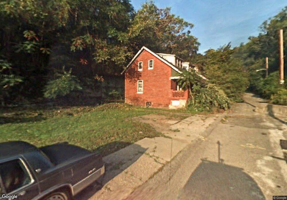
171 Lincoln Way Clairton, PA 15025
Estimated Value: $211,000
--
Bed
1
Bath
--
Sq Ft
2,091
Sq Ft Lot
About This Home
This home is located at 171 Lincoln Way, Clairton, PA 15025 and is currently estimated at $211,000. 171 Lincoln Way is a home located in Allegheny County with nearby schools including Clairton Elementary School, Clairton Middle School/High School, and Walnut Grove Christian School.
Ownership History
Date
Name
Owned For
Owner Type
Purchase Details
Closed on
Dec 28, 2023
Sold by
Clairton City
Bought by
Clairton City Redevelop Auth
Current Estimated Value
Purchase Details
Closed on
Dec 22, 2023
Sold by
City Of Clairton
Bought by
Redevelopment Authority Of The City Ofclairto
Purchase Details
Closed on
Dec 21, 2023
Sold by
Clairton City
Bought by
Clairton City Redevelop Auth
Purchase Details
Closed on
Aug 21, 1974
Bought by
Brown Fannie S and Dana Frederick Bro
Create a Home Valuation Report for This Property
The Home Valuation Report is an in-depth analysis detailing your home's value as well as a comparison with similar homes in the area
Home Values in the Area
Average Home Value in this Area
Purchase History
| Date | Buyer | Sale Price | Title Company |
|---|---|---|---|
| Clairton City Redevelop Auth | -- | -- | |
| Clairton City Redevelop Auth | -- | -- | |
| Redevelopment Authority Of The City Ofclairto | $500 | -- | |
| Clairton City Redevelop Auth | -- | -- | |
| Clairton City Redevelop Auth | -- | -- | |
| Brown Fannie S | -- | -- |
Source: Public Records
Tax History Compared to Growth
Tax History
| Year | Tax Paid | Tax Assessment Tax Assessment Total Assessment is a certain percentage of the fair market value that is determined by local assessors to be the total taxable value of land and additions on the property. | Land | Improvement |
|---|---|---|---|---|
| 2024 | $34 | $700 | $700 | -- |
| 2023 | $32 | $700 | $700 | $0 |
| 2022 | $32 | $700 | $700 | $0 |
| 2021 | $3 | $700 | $700 | $0 |
| 2020 | $32 | $700 | $700 | $0 |
| 2019 | $11 | $700 | $700 | $0 |
| 2018 | $48 | $700 | $700 | $0 |
| 2017 | $158 | $10,200 | $4,600 | $5,600 |
| 2016 | $48 | $10,200 | $4,600 | $5,600 |
| 2015 | $48 | $10,200 | $4,600 | $5,600 |
| 2014 | $48 | $10,200 | $4,600 | $5,600 |
Source: Public Records
Map
Nearby Homes
- 1045 Pennsylvania Ave
- 1019 Pennsylvania Ave
- 1017 Pennsylvania Ave
- 811 N State St
- 1252 Wall Ave
- 211 Pennsylvania Ave
- 756 N 6th St
- 373 New York Ave
- 124 Carnegie Ave
- 132 Carnegie Ave
- 717 N 6th St
- 574 State Route 885
- 203 Elm St
- 133 Coal Valley Rd
- 534 State Route 885
- 962 Ohio Ave
- 526 State Route 885
- 422 N 3rd St
- 427 N 4th St
- 514 Walnut Ave
- 173 Lincoln Way
- 175 Lincoln Way
- 181 Lincoln Way
- 158 Lincoln Way
- 156 Lincoln Way
- 153 Lincoln Way
- 152 Lincoln Way
- 227 Massachusetts Ave
- 231 Massachusetts Ave
- 191 Lincoln Way
- 235 Massachusetts Ave
- 147 Lincoln Way
- 223 Massachusetts Ave
- 146 Lincoln Way
- 239 Massachusetts Ave
- 0 Massachusetts Ave
- 145 Lincoln Way
- 197 Lincoln Way
- 143 Lincoln Way
- 243 Massachusetts Ave