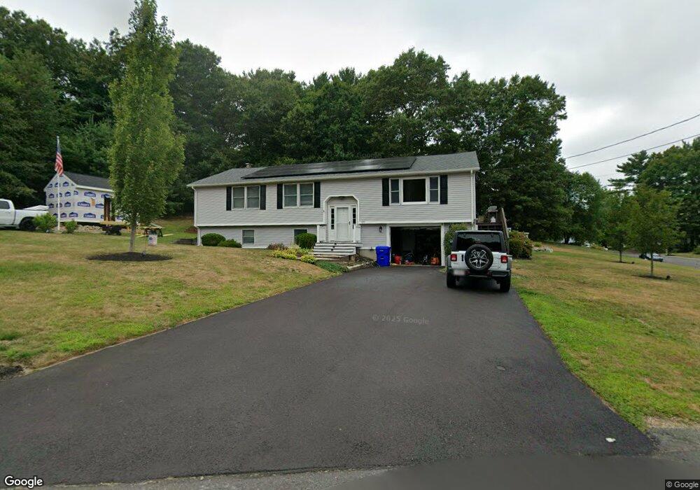
171 Mockingbird Way East Taunton, MA 02718
East Taunton NeighborhoodEstimated Value: $549,000 - $676,000
3
Beds
2
Baths
2,151
Sq Ft
$282/Sq Ft
Est. Value
About This Home
This home is located at 171 Mockingbird Way, East Taunton, MA 02718 and is currently estimated at $606,727, approximately $282 per square foot. 171 Mockingbird Way is a home located in Bristol County with nearby schools including East Taunton Elementary School, Joseph H. Martin, and Taunton High School.
Ownership History
Date
Name
Owned For
Owner Type
Purchase Details
Closed on
Jan 20, 2015
Sold by
Smith Jaime-Lynn
Bought by
Smith Richard H
Current Estimated Value
Purchase Details
Closed on
May 1, 2008
Sold by
King Richard and King Tara
Bought by
Smith Jaime Lynn and Smith Richard H
Home Financials for this Owner
Home Financials are based on the most recent Mortgage that was taken out on this home.
Original Mortgage
$296,805
Interest Rate
5.99%
Mortgage Type
Purchase Money Mortgage
Purchase Details
Closed on
Dec 21, 2001
Sold by
Edwards Jacob and Edwards Francine
Bought by
King Richard and King Tara
Home Financials for this Owner
Home Financials are based on the most recent Mortgage that was taken out on this home.
Original Mortgage
$225,000
Interest Rate
6.54%
Mortgage Type
Purchase Money Mortgage
Create a Home Valuation Report for This Property
The Home Valuation Report is an in-depth analysis detailing your home's value as well as a comparison with similar homes in the area
Home Values in the Area
Average Home Value in this Area
Purchase History
| Date | Buyer | Sale Price | Title Company |
|---|---|---|---|
| Smith Richard H | -- | -- | |
| Smith Jaime Lynn | $299,150 | -- | |
| King Richard | $237,000 | -- |
Source: Public Records
Mortgage History
| Date | Status | Borrower | Loan Amount |
|---|---|---|---|
| Previous Owner | Smith Jaime Lynn | $296,805 | |
| Previous Owner | King Richard | $225,000 |
Source: Public Records
Tax History Compared to Growth
Tax History
| Year | Tax Paid | Tax Assessment Tax Assessment Total Assessment is a certain percentage of the fair market value that is determined by local assessors to be the total taxable value of land and additions on the property. | Land | Improvement |
|---|---|---|---|---|
| 2025 | $5,469 | $499,900 | $140,200 | $359,700 |
| 2024 | $5,123 | $457,800 | $140,200 | $317,600 |
| 2023 | $5,025 | $417,000 | $133,800 | $283,200 |
| 2022 | $4,995 | $379,000 | $122,100 | $256,900 |
| 2021 | $4,709 | $331,600 | $111,000 | $220,600 |
| 2020 | $4,598 | $309,400 | $111,000 | $198,400 |
| 2019 | $4,684 | $297,200 | $111,000 | $186,200 |
| 2018 | $4,513 | $287,100 | $112,100 | $175,000 |
| 2017 | $4,228 | $269,100 | $106,300 | $162,800 |
| 2016 | $4,078 | $260,100 | $103,200 | $156,900 |
| 2015 | $3,927 | $261,600 | $105,100 | $156,500 |
| 2014 | $3,793 | $259,600 | $105,100 | $154,500 |
Source: Public Records
Map
Nearby Homes
- 220 Erin Rd
- 81 Tania Dr
- 203 Bluejay Ln
- 28 B Staples St Unit B
- 550 Middleboro Ave
- 96 Old Colony Ave Unit 264
- 68 Metacomet Ave
- 649 Middleboro Ave
- 96 Old Colony Ave Unit 318
- 96 Old Colony Ave Unit 268
- 96 Old Colony Ave Unit 202
- 218R Hart St Unit B
- 120 South St E
- 32 Kendall Ct
- 17 Maries Way
- 210 Linsay Dr
- 31 Bruno's Way Unit A
- 3 Karena Dr Unit 8
- 170 Hart St Unit B
- 138 Pine Tree Ln
- 65 Hummingbird Ln
- 16 Bluejay Ln
- 30 Bluejay Ln
- 101 Hummingbird Ln
- 68 Hummingbird Ln
- 156 Mockingbird Way
- 51 Hummingbird Ln
- 6 Bluejay Ln
- 100 Hummingbird Ln
- 206 Mockingbird Way
- 121 Hummingbird Ln
- 9 Bluejay Ln
- 50 Hummingbird Ln
- 116 Hummingbird Ln
- 131 Mockingbird Way
- 25 Bluejay Ln
- 41 Hummingbird Ln
- 35 Bluejay Ln
- 23 Wren St
- 41 Wren St