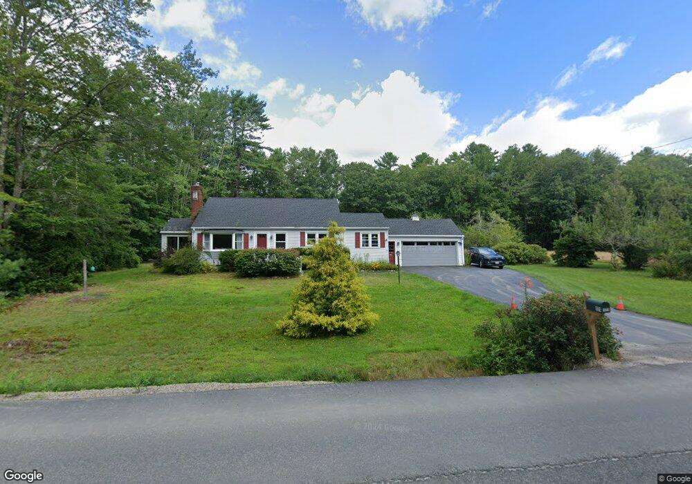
171 Western Ave Kennebunk, ME 04043
Estimated Value: $686,000 - $1,080,000
4
Beds
2
Baths
2,196
Sq Ft
$383/Sq Ft
Est. Value
About This Home
This home is located at 171 Western Ave, Kennebunk, ME 04043 and is currently estimated at $840,333, approximately $382 per square foot. 171 Western Ave is a home located in York County with nearby schools including Kennebunk High School and The New School.
Ownership History
Date
Name
Owned For
Owner Type
Purchase Details
Closed on
Dec 28, 2023
Sold by
Belyea Steven P and Reid Karen A
Bought by
Maguire-Stirk Mandy and Stirk Timothy
Current Estimated Value
Home Financials for this Owner
Home Financials are based on the most recent Mortgage that was taken out on this home.
Original Mortgage
$225,000
Outstanding Balance
$221,413
Interest Rate
7.44%
Mortgage Type
Purchase Money Mortgage
Estimated Equity
$618,920
Purchase Details
Closed on
Nov 7, 2023
Sold by
Stirk Barbara J
Bought by
Stirk Timothy
Home Financials for this Owner
Home Financials are based on the most recent Mortgage that was taken out on this home.
Original Mortgage
$225,000
Outstanding Balance
$221,413
Interest Rate
7.44%
Mortgage Type
Purchase Money Mortgage
Estimated Equity
$618,920
Purchase Details
Closed on
Oct 13, 2023
Sold by
Raymond P Belyea Lt and Belyea
Bought by
Belyea Steven P and Stirk Barbara J
Create a Home Valuation Report for This Property
The Home Valuation Report is an in-depth analysis detailing your home's value as well as a comparison with similar homes in the area
Home Values in the Area
Average Home Value in this Area
Purchase History
| Date | Buyer | Sale Price | Title Company |
|---|---|---|---|
| Maguire-Stirk Mandy | $600,000 | None Available | |
| Stirk Timothy | -- | None Available | |
| Belyea Steven P | -- | None Available |
Source: Public Records
Mortgage History
| Date | Status | Borrower | Loan Amount |
|---|---|---|---|
| Open | Maguire-Stirk Mandy | $225,000 |
Source: Public Records
Tax History Compared to Growth
Tax History
| Year | Tax Paid | Tax Assessment Tax Assessment Total Assessment is a certain percentage of the fair market value that is determined by local assessors to be the total taxable value of land and additions on the property. | Land | Improvement |
|---|---|---|---|---|
| 2024 | $7,568 | $446,500 | $207,800 | $238,700 |
| 2023 | $7,166 | $446,500 | $207,800 | $238,700 |
| 2022 | $6,519 | $446,500 | $207,800 | $238,700 |
| 2021 | $5,921 | $446,500 | $207,800 | $238,700 |
| 2020 | $5,879 | $446,500 | $207,800 | $238,700 |
| 2019 | $6,139 | $446,500 | $207,800 | $238,700 |
| 2018 | $5,863 | $335,000 | $155,900 | $179,100 |
| 2017 | $120 | $335,000 | $155,900 | $179,100 |
| 2016 | $5,327 | $335,000 | $155,900 | $179,100 |
| 2015 | $4,264 | $293,900 | $114,800 | $179,100 |
| 2014 | $4,153 | $293,900 | $114,800 | $179,100 |
Source: Public Records
Map
Nearby Homes
- 12 Ephraim Tyler Way
- 20 Ephraim Tyler Way Unit 20
- 53 Great Hill Rd
- 15 Benjamin Hubbard Ln Unit 15
- 40 Shorebreezes Ln Unit 40
- 57 Southgate Rd
- 87 Boothby Rd
- 20 Surf Ln
- 175 Beach Ave Unit 2
- 147 Beach Ave Unit 42
- 143 Beach Ave Unit 205
- 143 Beach Ave Unit 203
- 149 Beach Ave Unit 107
- 14 Rachel Dr
- 6 Old Port Rd
- 17 Bayberry Ave
- 12 Wallace St
- 161 Brown St
- Lot#39 Bufflehead Cove Ln
- 93 Beach Ave
- 3 Driftwood Ln
- 165 Western Ave
- 166 Western Ave
- 18 Sea Garden Cir
- 16 Sea Garden Cir
- 162 Western Ave
- 178 Western Ave
- 2 Christopher Rd
- 4 Christopher Rd
- 2 Driftwood Ln
- 14 Sea Garden Cir
- 158 Western Ave
- 160 Western Ave
- 20 Sea Garden Cir
- 6 Christopher Rd
- 21 Sea Garden Cir
- 1 Christopher Rd
- 9 Carriage Ln
- 24 Sea Garden Cir
- 3 Christopher Rd