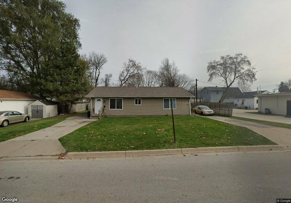
1710 12th Ave Port Huron, MI 48060
Estimated Value: $138,622 - $162,000
3
Beds
2
Baths
1,762
Sq Ft
$86/Sq Ft
Est. Value
About This Home
This home is located at 1710 12th Ave, Port Huron, MI 48060 and is currently estimated at $152,156, approximately $86 per square foot. 1710 12th Ave is a home located in St. Clair County with nearby schools including H.D. Crull Elementary School, Holland Woods Middle School, and Port Huron Northern High School.
Ownership History
Date
Name
Owned For
Owner Type
Purchase Details
Closed on
Apr 29, 2010
Sold by
Caryl Terry G and Caryl Karen L
Bought by
Citizens First Mortgage Llc
Current Estimated Value
Purchase Details
Closed on
Aug 27, 2009
Sold by
Caryl Karen L and Caryl Terry G
Bought by
Caryl Karen L and The Karen L Caryl Revocable Trust
Create a Home Valuation Report for This Property
The Home Valuation Report is an in-depth analysis detailing your home's value as well as a comparison with similar homes in the area
Home Values in the Area
Average Home Value in this Area
Purchase History
| Date | Buyer | Sale Price | Title Company |
|---|---|---|---|
| Citizens First Mortgage Llc | $83,681 | None Available | |
| Caryl Karen L | -- | None Available |
Source: Public Records
Tax History Compared to Growth
Tax History
| Year | Tax Paid | Tax Assessment Tax Assessment Total Assessment is a certain percentage of the fair market value that is determined by local assessors to be the total taxable value of land and additions on the property. | Land | Improvement |
|---|---|---|---|---|
| 2025 | $2,016 | $64,600 | $0 | $0 |
| 2024 | $1,752 | $61,700 | $0 | $0 |
| 2023 | $1,659 | $55,000 | $0 | $0 |
| 2022 | $1,646 | $47,100 | $0 | $0 |
| 2021 | $1,572 | $43,200 | $0 | $0 |
| 2020 | $1,578 | $40,100 | $40,100 | $0 |
| 2019 | $1,550 | $27,500 | $0 | $0 |
| 2018 | $1,515 | $27,500 | $0 | $0 |
| 2017 | $1,391 | $25,900 | $0 | $0 |
| 2016 | $1,235 | $25,900 | $0 | $0 |
| 2015 | $1,212 | $23,500 | $23,500 | $0 |
| 2014 | $1,212 | $22,500 | $22,500 | $0 |
| 2013 | -- | $22,500 | $0 | $0 |
Source: Public Records
Map
Nearby Homes
- 1620 McBrady St
- 1649 Whipple St
- 1733 Whipple St
- 1433 Poplar St
- 1907 Riverside Dr
- 1819 Riverside Dr
- 1417 Kearney St
- 0000 Campau Ave
- 2400 Stone St Unit 2414
- 29 Taylor St
- 1321 Nelson St
- 1116 Hancock St
- 917 Saint Clair St
- 2419 Cherry St
- 2215 Hancock St
- 1002 Erie St
- 1819 Kern St
- 1825 Kern St
- 711 Stanton St
- 2736 17th Ave
- 1710 12th Ave Unit 1712
- 1534 Mcpherson St
- 1523 Whipple St
- 1517 Whipple St
- 1600 McBrady St
- 1600 McBrady St
- 1600 McBrady St
- 1600 McBrady St
- 1600 McBrady St
- 1530 Mcpherson St
- 1515 Whipple St
- 1602 McBrady St
- 1607 McBrady St
- 1518 Mcpherson St
- 1603 Whipple St
- 1615 McBrady St
- 1612 McBrady St
- 1600 Mcpherson St
- 1600 Mcpherson St
- 1605 Whipple St