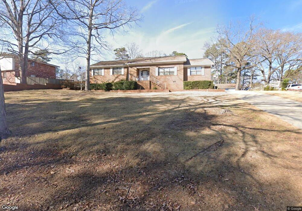
1710 Carl Rd Columbia, SC 29210
Saint Andrews NeighborhoodEstimated Value: $266,000 - $282,000
3
Beds
2
Baths
2,603
Sq Ft
$105/Sq Ft
Est. Value
About This Home
This home is located at 1710 Carl Rd, Columbia, SC 29210 and is currently estimated at $272,356, approximately $104 per square foot. 1710 Carl Rd is a home located in Richland County with nearby schools including H. B. Rhame Elementary School, St. Andrews Middle School, and Columbia High School.
Ownership History
Date
Name
Owned For
Owner Type
Purchase Details
Closed on
Nov 6, 2006
Sold by
Murphy Patricia Ann
Bought by
Murphy Patricia A and Murphy Philip
Current Estimated Value
Purchase Details
Closed on
Apr 7, 2004
Sold by
Outlaw Dempsey E
Bought by
Murphy Philip B and Murphy Patricia A
Home Financials for this Owner
Home Financials are based on the most recent Mortgage that was taken out on this home.
Original Mortgage
$177,828
Outstanding Balance
$82,983
Interest Rate
5.54%
Mortgage Type
VA
Estimated Equity
$189,373
Purchase Details
Closed on
May 22, 2001
Sold by
Outlaw Dempsey E
Bought by
Outlaw Dempsey E
Create a Home Valuation Report for This Property
The Home Valuation Report is an in-depth analysis detailing your home's value as well as a comparison with similar homes in the area
Home Values in the Area
Average Home Value in this Area
Purchase History
| Date | Buyer | Sale Price | Title Company |
|---|---|---|---|
| Murphy Patricia A | -- | None Available | |
| Murphy Philip B | $174,000 | -- | |
| Outlaw Dempsey E | -- | -- |
Source: Public Records
Mortgage History
| Date | Status | Borrower | Loan Amount |
|---|---|---|---|
| Open | Murphy Philip B | $177,828 |
Source: Public Records
Tax History Compared to Growth
Tax History
| Year | Tax Paid | Tax Assessment Tax Assessment Total Assessment is a certain percentage of the fair market value that is determined by local assessors to be the total taxable value of land and additions on the property. | Land | Improvement |
|---|---|---|---|---|
| 2024 | $1,351 | $182,100 | $0 | $0 |
| 2023 | $1,296 | $6,332 | $0 | $0 |
| 2022 | $1,145 | $158,300 | $17,100 | $141,200 |
| 2021 | $1,142 | $6,330 | $0 | $0 |
| 2020 | $1,160 | $6,330 | $0 | $0 |
| 2019 | $1,134 | $6,330 | $0 | $0 |
| 2018 | $1,019 | $5,780 | $0 | $0 |
| 2017 | $997 | $5,780 | $0 | $0 |
| 2016 | $993 | $5,780 | $0 | $0 |
| 2015 | $967 | $5,780 | $0 | $0 |
| 2014 | $1,182 | $144,500 | $0 | $0 |
| 2013 | -- | $5,780 | $0 | $0 |
Source: Public Records
Map
Nearby Homes
- 1650 Omarest Dr
- 1712 Omarest Dr
- 201 Burbank St
- 232 Burbank St
- 1820 Omarest Dr
- 112 Gateway Ln
- 321 Cambout St
- 105 River Bluff Ct
- 529 Cambout St
- 214 River Bluff Way
- 1850 Atlantic Dr
- 1850 Atlantic Dr Unit 416
- 1510 Canal Dr
- 409 Huntley Way
- 2103 Marley Dr
- 1904 Elise Dr
- 1127 Shirlington Rd
- 2006 Mary Hill Dr
- 1509 Nunamaker Dr
- 2116 Chandler Ave
- 1718 Carl Rd
- 1706 Carl Rd
- 1634 Koulter Dr
- 1622 Koulter Dr
- 1707 Carl Rd
- 1640 Koulter Dr
- 1724 Carl Rd
- 1729 Carl Rd
- 1725 Carl Rd
- 1614 Koulter Dr
- 1721 Carl Rd
- 1804 Bengston St
- 1708 Jayne Ln
- 1619 Koulter Dr
- 1730 Carl Rd
- 1712 Jayne Ln
- 1604 Koulter Dr
- 1656 Koulter Dr
- 0 Koulter Dr Unit 586355
- 0 Koulter Dr Unit 586353