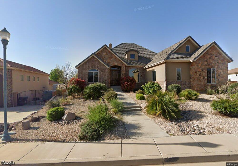
1710 E 290 S Unit Lot 429 Saint George, UT 84790
Estimated Value: $892,000 - $1,080,124
6
Beds
4
Baths
5,825
Sq Ft
$172/Sq Ft
Est. Value
About This Home
This home is located at 1710 E 290 S Unit Lot 429, Saint George, UT 84790 and is currently estimated at $999,781, approximately $171 per square foot. 1710 E 290 S Unit Lot 429 is a home located in Washington County with nearby schools including Heritage School, Dixie Middle School, and Dixie Intermediate School.
Ownership History
Date
Name
Owned For
Owner Type
Purchase Details
Closed on
Jul 12, 2010
Sold by
Skyline Real Estate
Bought by
Kimball William O and William O Kimball Family Livin
Current Estimated Value
Purchase Details
Closed on
Apr 17, 2008
Sold by
Hauzen Joseph B and Hauzen Janice J
Bought by
Skyline Real Estate
Purchase Details
Closed on
Sep 16, 2006
Sold by
Foremaster Ridge Development Llc
Bought by
Cygnus Development Inc
Home Financials for this Owner
Home Financials are based on the most recent Mortgage that was taken out on this home.
Original Mortgage
$149,581
Interest Rate
6.53%
Mortgage Type
Unknown
Purchase Details
Closed on
Sep 13, 2006
Sold by
Cygnus Development Inc
Bought by
Hauzen Joseph B and Hauzen Janice J
Home Financials for this Owner
Home Financials are based on the most recent Mortgage that was taken out on this home.
Original Mortgage
$149,581
Interest Rate
6.53%
Mortgage Type
Unknown
Create a Home Valuation Report for This Property
The Home Valuation Report is an in-depth analysis detailing your home's value as well as a comparison with similar homes in the area
Home Values in the Area
Average Home Value in this Area
Purchase History
| Date | Buyer | Sale Price | Title Company |
|---|---|---|---|
| Kimball William O | -- | First American Ncs South Tem | |
| Skyline Real Estate | -- | First American Ncs South Tem | |
| Cygnus Development Inc | -- | Dixie Title Co | |
| Hauzen Joseph B | -- | Dixie Title Co |
Source: Public Records
Mortgage History
| Date | Status | Borrower | Loan Amount |
|---|---|---|---|
| Previous Owner | Hauzen Joseph B | $149,581 | |
| Previous Owner | Cygnus Development Inc | $653,000 | |
| Previous Owner | Hauzen Joseph B | $653,000 |
Source: Public Records
Tax History Compared to Growth
Tax History
| Year | Tax Paid | Tax Assessment Tax Assessment Total Assessment is a certain percentage of the fair market value that is determined by local assessors to be the total taxable value of land and additions on the property. | Land | Improvement |
|---|---|---|---|---|
| 2025 | $6,757 | $1,013,700 | $210,000 | $803,700 |
| 2023 | $6,417 | $958,800 | $210,000 | $748,800 |
| 2022 | $6,803 | $955,900 | $205,000 | $750,900 |
| 2021 | $6,254 | $720,700 | $115,000 | $605,700 |
| 2020 | $5,655 | $613,800 | $115,000 | $498,800 |
| 2019 | $5,545 | $588,000 | $115,000 | $473,000 |
| 2018 | $5,213 | $518,900 | $0 | $0 |
| 2017 | $0 | $524,500 | $0 | $0 |
| 2016 | $5,424 | $484,800 | $0 | $0 |
| 2015 | $5,588 | $479,200 | $0 | $0 |
| 2014 | $5,125 | $442,300 | $0 | $0 |
Source: Public Records
Map
Nearby Homes
- 1684 E 290 S
- 0 Null Unit 25-258376
- 232 S Acantilado Cir
- 1646 E 90 Cir S
- 5409 S Aquamarine Ln
- 5394 S Aquamarine Ln
- 5931 S Orchid Cove
- 5416 S Aquamarine Ln
- 5401 S Aquamarine Ln
- 5409 S Aquamarine Ln Unit 257
- 5398 S Aquamarine Ln
- 110 S Eastridge Dr
- 145 N Mall Dr Unit 33
- 145 N Mall Dr Unit 35
- 145 N Mall Dr Unit 59
- 145 N Mall Dr Unit 57
- 236 S 2020 Cir E
- 84 N Eastridge Dr
- 301 S 1200 E Unit 47
- 301 S 1200 E Unit 89
- 1710 E 290 S
- 3416 E 290 S
- 1724 E 290 S
- 1696 E 290 S
- 0 290 St S
- 1715 E 290 S
- 1721 E 330 S
- Lot 433 290 St S
- 1733 E 290 S
- 1705 E 330 S
- 296 S Crestline Dr
- 1697 E 290 S
- 1737 E 330 S
- 1684 E 290 S Unit 427
- 0 Foremaster Ridge Lot 427
- 230 South Cir
- 248 S Crestline Dr
- 317 S Eastridge Dr
- 0 E 330 S
- 277 S Crestline Dr