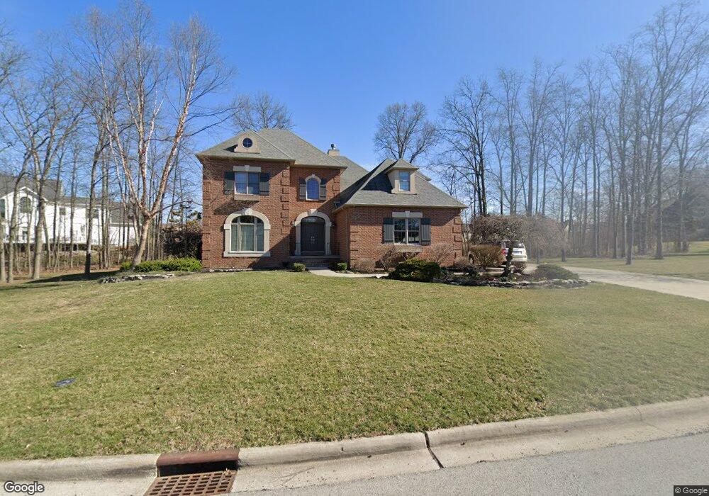
1710 Firestone Dr Findlay, OH 45840
Estimated Value: $688,000 - $721,000
4
Beds
5
Baths
3,331
Sq Ft
$211/Sq Ft
Est. Value
About This Home
This home is located at 1710 Firestone Dr, Findlay, OH 45840 and is currently estimated at $703,328, approximately $211 per square foot. 1710 Firestone Dr is a home located in Hancock County with nearby schools including Liberty-Benton Elementary School, Liberty-Benton Middle School, and Liberty-Benton High School.
Ownership History
Date
Name
Owned For
Owner Type
Purchase Details
Closed on
Dec 3, 2012
Sold by
Schroeder Gary C and Schroeder Tamara S
Bought by
Montalbine Christopher J and Montalbine Michelle E
Current Estimated Value
Home Financials for this Owner
Home Financials are based on the most recent Mortgage that was taken out on this home.
Original Mortgage
$392,000
Interest Rate
2.69%
Mortgage Type
New Conventional
Create a Home Valuation Report for This Property
The Home Valuation Report is an in-depth analysis detailing your home's value as well as a comparison with similar homes in the area
Purchase History
| Date | Buyer | Sale Price | Title Company |
|---|---|---|---|
| Montalbine Christopher J | $490,000 | Mid Am Title Agency |
Source: Public Records
Mortgage History
| Date | Status | Borrower | Loan Amount |
|---|---|---|---|
| Closed | Montalbine Christopher J | $392,000 |
Source: Public Records
Tax History
| Year | Tax Paid | Tax Assessment Tax Assessment Total Assessment is a certain percentage of the fair market value that is determined by local assessors to be the total taxable value of land and additions on the property. | Land | Improvement |
|---|---|---|---|---|
| 2024 | $7,536 | $202,720 | $29,240 | $173,480 |
| 2023 | $7,358 | $202,720 | $29,240 | $173,480 |
| 2022 | $7,286 | $202,720 | $29,240 | $173,480 |
| 2021 | $7,201 | $176,860 | $29,240 | $147,620 |
| 2020 | $7,262 | $176,860 | $29,240 | $147,620 |
| 2019 | $6,968 | $176,860 | $29,240 | $147,620 |
| 2018 | $5,861 | $164,220 | $19,490 | $144,730 |
| 2017 | $6,047 | $164,220 | $19,490 | $144,730 |
| 2016 | $5,848 | $164,220 | $19,490 | $144,730 |
| 2015 | $5,311 | $145,030 | $17,640 | $127,390 |
| 2014 | $5,359 | $145,030 | $17,640 | $127,390 |
| 2012 | $5,596 | $145,030 | $17,640 | $127,390 |
Source: Public Records
Map
Nearby Homes
- 6535 Silver Lake Dr
- 0 County Road 95 Unit 6097574
- 3106 Saddlebrook
- 3018 Gleneagle Dr
- 9894 Smokies Way
- 3237 Gleneagle Dr
- 0 County Road 140
- 0 Rock Candy Rd Or Bushwillow Dr Unit Lot 173
- 0 Rock Candy Rd Unit Lot 159
- 0 Rock Candy Rd Unit Lot 170
- 0 Rock Candy Rd Unit Lot 172 206819
- 0 Rock Candy Rd Unit Lot 162
- 0 Rock Candy Rd Unit Lot 171
- 0 Rock Candy Rd Unit Lot 168
- 0 Bushwillow Dr Or Rock Candy Rd Unit Lot 157
- 0 Bearcat Way Or Rock Candy Rd Unit Lot 167
- 925 W Melrose Ave
- 9960 W 224 Us Hwy
- 0 County Road 223
- 724 Edith Ave
- 1709 Bay Hill Dr
- 1701 Bay Hill Dr
- 1717 Firestone Dr
- 1717 Bay Hill Dr
- 1709 Firestone Dr
- 1627 Bay Hill Dr
- 1701 Firestone Dr
- 1725 Firestone Dr
- 1625 Firestone Dr
- 1617 Bay Hill Dr
- 1733 Firestone Dr
- 1702 Bay Hill Dr
- 1710 Bay Hill Dr
- 0 Firestone Dr Unit 6040150
- 0 Firestone Dr Unit 6083947
- 0 Firestone Dr Unit H139520
- 69 Firestone Dr
- 68 Firestone Dr
- 67 Firestone Dr
- 0 Firestone Dr Unit 6040140
Your Personal Tour Guide
Ask me questions while you tour the home.