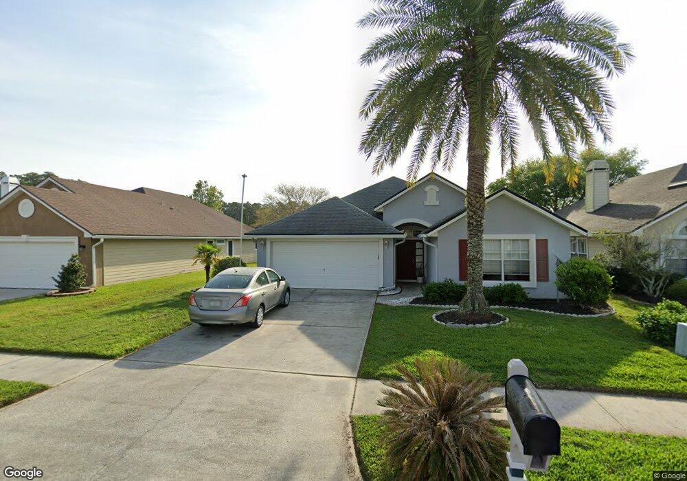
1710 Rustling Dr Fleming Island, FL 32003
Estimated Value: $356,000 - $403,000
4
Beds
2
Baths
1,982
Sq Ft
$193/Sq Ft
Est. Value
About This Home
This home is located at 1710 Rustling Dr, Fleming Island, FL 32003 and is currently estimated at $383,142, approximately $193 per square foot. 1710 Rustling Dr is a home located in Clay County with nearby schools including Fleming Island Elementary School, Fleming Island High School, and Lakeside Junior High School.
Ownership History
Date
Name
Owned For
Owner Type
Purchase Details
Closed on
Jun 18, 2020
Sold by
Mooney Michael R and Money Michael Robert
Bought by
Mooney Michael R and Mooney Michael Ross
Current Estimated Value
Purchase Details
Closed on
May 28, 2010
Sold by
Anderson Stephen R and Tapee Kirsten
Bought by
Mooney Michael R and Mooney Patricia M
Purchase Details
Closed on
Jul 23, 2003
Sold by
Craig Steven A
Bought by
Anderson Robert F
Purchase Details
Closed on
Jul 26, 2001
Sold by
C Richard Dobson Builders Inc
Bought by
Craig Steven A and Craig Janet C
Home Financials for this Owner
Home Financials are based on the most recent Mortgage that was taken out on this home.
Original Mortgage
$153,000
Interest Rate
7.08%
Mortgage Type
Purchase Money Mortgage
Purchase Details
Closed on
Dec 12, 2000
Sold by
Eagle Harbor At Fleming Island Joint Ven
Bought by
C Richard Dobson Builders Inc
Create a Home Valuation Report for This Property
The Home Valuation Report is an in-depth analysis detailing your home's value as well as a comparison with similar homes in the area
Home Values in the Area
Average Home Value in this Area
Purchase History
| Date | Buyer | Sale Price | Title Company |
|---|---|---|---|
| Mooney Michael R | -- | Attorney | |
| Mooney Michael R | $172,000 | Attorney | |
| Anderson Robert F | $197,000 | -- | |
| Craig Steven A | $173,000 | -- | |
| C Richard Dobson Builders Inc | $67,600 | -- |
Source: Public Records
Mortgage History
| Date | Status | Borrower | Loan Amount |
|---|---|---|---|
| Previous Owner | Craig Steven A | $153,000 |
Source: Public Records
Tax History
| Year | Tax Paid | Tax Assessment Tax Assessment Total Assessment is a certain percentage of the fair market value that is determined by local assessors to be the total taxable value of land and additions on the property. | Land | Improvement |
|---|---|---|---|---|
| 2025 | $2,111 | $185,421 | -- | -- |
| 2024 | $3,134 | $180,196 | -- | -- |
| 2023 | $3,134 | $174,948 | $0 | $0 |
| 2022 | $2,870 | $169,853 | $0 | $0 |
| 2021 | $2,860 | $164,906 | $0 | $0 |
| 2020 | $2,788 | $162,630 | $0 | $0 |
| 2019 | $2,755 | $158,974 | $0 | $0 |
| 2018 | $2,583 | $156,010 | $0 | $0 |
| 2017 | $2,571 | $152,801 | $0 | $0 |
| 2016 | $2,414 | $149,658 | $0 | $0 |
| 2015 | $3,130 | $148,618 | $0 | $0 |
| 2014 | $3,182 | $147,438 | $0 | $0 |
Source: Public Records
Map
Nearby Homes
- 1884 Lake Forest Ln
- 1944 Trout River Ct
- 2317 Range Crescent Ct
- 1508 Bay Harbor Dr
- 2045 Secret Garden Ln Unit 605
- 2198 Blue Heron Cove Dr
- 2372 Stoney Glen Dr
- 2035 Secret Garden Ln Unit 505
- 2035 Secret Garden Ln Unit 506
- 1684 Sanctuary Way
- 1693 Sanctuary Way
- 1733 Sanctuary Way
- 2480 Stoney Glen Dr
- 1850 Waterbury Ln
- 2299 S Brook Dr
- 1576 Linkside Dr
- 1683 Waters Edge Dr
- 2171 Deer Run Ln
- 98 Swimming Pen Dr
- 2262 Eagle Harbor Pkwy
- 1706 Rustling Dr
- 1714 Rustling Dr
- 1702 Rustling Dr
- 1718 Rustling Dr
- 1715 Rustling Dr
- 1722 Rustling Dr
- 1694 Rustling Dr
- 1711 Rustling Dr
- 1707 Rustling Dr
- 1703 Rustling Dr
- 1726 Rustling Dr
- 1719 Rustling Dr
- 1699 Rustling Dr
- 1690 Rustling Dr
- 1678 Rustling Dr
- 1723 Rustling Dr
- 1730 Rustling Dr
- 1929 Lake Forest Ln
- 1674 Rustling Dr
- 1727 Rustling Dr
Your Personal Tour Guide
Ask me questions while you tour the home.