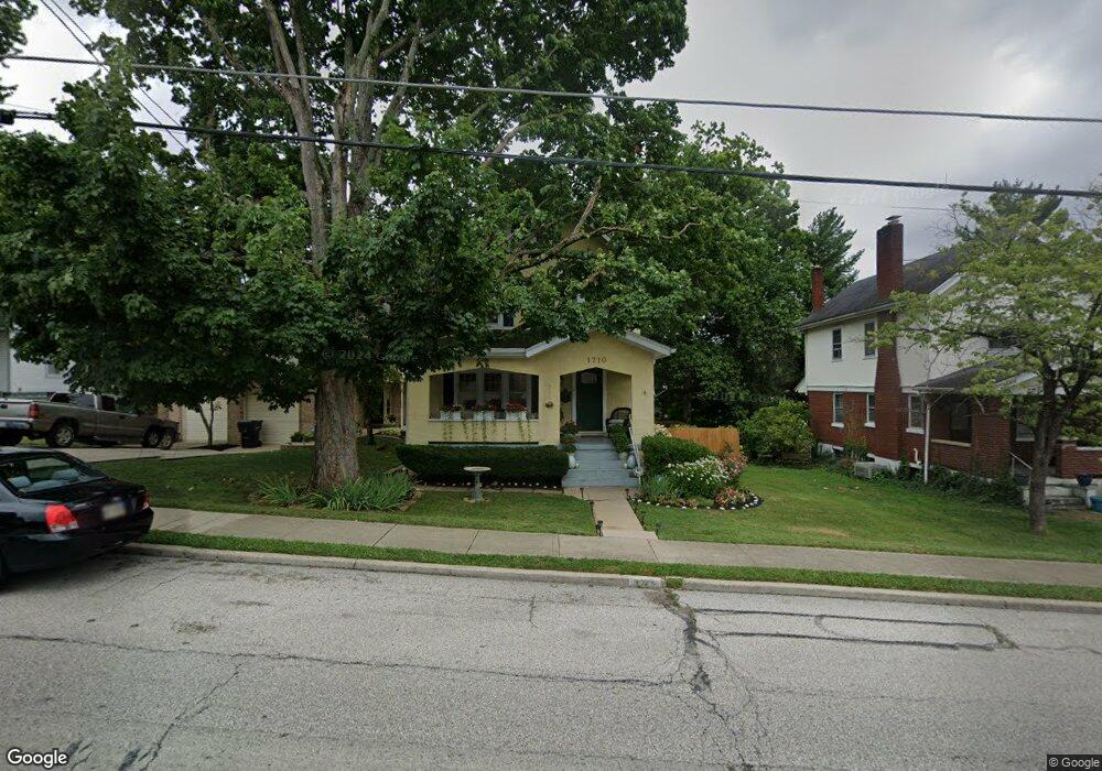
1710 Sutton Ave Cincinnati, OH 45230
Mount Washington NeighborhoodEstimated Value: $274,603 - $284,000
3
Beds
2
Baths
1,937
Sq Ft
$144/Sq Ft
Est. Value
About This Home
This home is located at 1710 Sutton Ave, Cincinnati, OH 45230 and is currently estimated at $279,151, approximately $144 per square foot. 1710 Sutton Ave is a home located in Hamilton County with nearby schools including Mt. Washington Elementary School, Clark Montessori High School, and Shroder High School.
Ownership History
Date
Name
Owned For
Owner Type
Purchase Details
Closed on
Apr 2, 1991
Sold by
Wallace Nancy Ann
Bought by
Wallace William Scott
Current Estimated Value
Create a Home Valuation Report for This Property
The Home Valuation Report is an in-depth analysis detailing your home's value as well as a comparison with similar homes in the area
Home Values in the Area
Average Home Value in this Area
Purchase History
| Date | Buyer | Sale Price | Title Company |
|---|---|---|---|
| Wallace William Scott | $88,000 | -- |
Source: Public Records
Tax History
| Year | Tax Paid | Tax Assessment Tax Assessment Total Assessment is a certain percentage of the fair market value that is determined by local assessors to be the total taxable value of land and additions on the property. | Land | Improvement |
|---|---|---|---|---|
| 2025 | $3,778 | $71,299 | $9,615 | $61,684 |
| 2023 | $4,369 | $71,299 | $9,615 | $61,684 |
| 2022 | $3,289 | $48,094 | $8,075 | $40,019 |
| 2021 | $3,164 | $48,094 | $8,075 | $40,019 |
| 2020 | $3,254 | $48,094 | $8,075 | $40,019 |
| 2019 | $3,122 | $42,189 | $7,084 | $35,105 |
| 2018 | $3,127 | $42,189 | $7,084 | $35,105 |
| 2017 | $2,971 | $42,189 | $7,084 | $35,105 |
| 2016 | $2,793 | $39,123 | $8,099 | $31,024 |
| 2015 | $2,519 | $39,123 | $8,099 | $31,024 |
| 2014 | $2,536 | $39,123 | $8,099 | $31,024 |
| 2013 | $2,582 | $39,123 | $8,099 | $31,024 |
Source: Public Records
Map
Nearby Homes
- 6029 Lockard Ave
- 1741 Mears Ave
- 1508 Beth Ln
- 6050 Colter Ave
- 1944 Rockland Ave
- 5965 Wayside Ave
- 1229 Meadowbright Ln
- 6952 Shadow Ridge Rd
- 1190 Linden Hill Ln
- 1627 Alcor Terrace
- 2111 Sutton Ave
- 1341 Mayland Dr
- 6122 Corbly Rd
- 3 Salem Rd
- 2 Salem Rd
- 4 Salem Rd
- 2133 Ronaldson Ave
- 6263 Corbly Rd
- 1 Salem Rd
- 6050 Bagdad Dr
- A Sutton Ave
- 1712 Sutton Ave
- 1712 Sutton Ave
- 1712 Sutton Ave Unit A
- 6114 Cambridge Ave
- 1714 Sutton Ave
- 6118 Cambridge Ave
- 1662 Sutton Ave
- 1720 Sutton Ave
- 1705 Sutton Ave Unit 8
- 1705 Sutton Ave Unit 5
- 1705 Sutton Ave Unit 7
- 6121 Cambridge Ave
- 6122 Cambridge Ave
- 6115 Cambridge Ave
- 1701 Sutton Ave
- 1713 Sutton Ave
- 1650 Sutton Ave
- 1726 Sutton Ave
- 1663 Sutton Ave
Your Personal Tour Guide
Ask me questions while you tour the home.