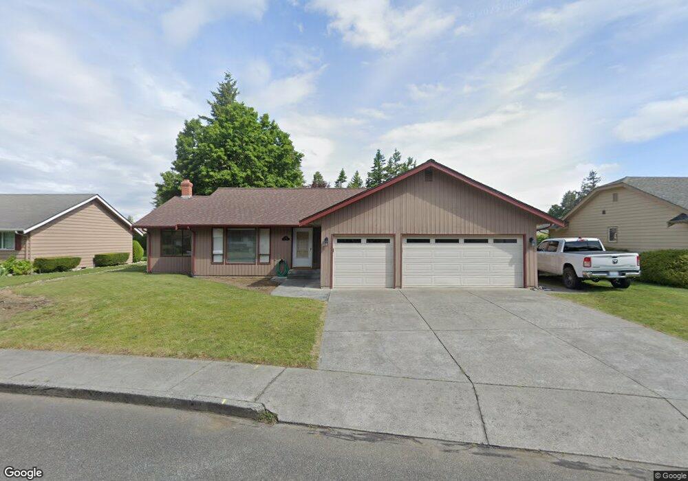
1710 Village Dr Lynden, WA 98264
Estimated Value: $588,000 - $674,000
3
Beds
2
Baths
1,900
Sq Ft
$332/Sq Ft
Est. Value
About This Home
This home is located at 1710 Village Dr, Lynden, WA 98264 and is currently estimated at $629,965, approximately $331 per square foot. 1710 Village Dr is a home located in Whatcom County with nearby schools including Lynden High School, Lynden Christian School, and Lynden Christian Schools: Administration.
Ownership History
Date
Name
Owned For
Owner Type
Purchase Details
Closed on
Oct 19, 2020
Sold by
Wilson Brent and Wilson Patricia L
Bought by
Mccauley Sean
Current Estimated Value
Home Financials for this Owner
Home Financials are based on the most recent Mortgage that was taken out on this home.
Original Mortgage
$418,000
Outstanding Balance
$371,111
Interest Rate
2.8%
Mortgage Type
New Conventional
Estimated Equity
$258,854
Purchase Details
Closed on
Apr 3, 2009
Sold by
Konstad Elizabeth Lea
Bought by
Wilson Brent and Wilson Patricia L
Purchase Details
Closed on
Jul 16, 2001
Sold by
Konstad Robert and Konstad Anne C
Bought by
Konstad Erik Thomle and Konstad Elizabeth Lea
Create a Home Valuation Report for This Property
The Home Valuation Report is an in-depth analysis detailing your home's value as well as a comparison with similar homes in the area
Home Values in the Area
Average Home Value in this Area
Purchase History
| Date | Buyer | Sale Price | Title Company |
|---|---|---|---|
| Mccauley Sean | $440,000 | Whatcom Land Title | |
| Mccauley Sean | $7,045,000 | Whatcom Land Title | |
| Mccauley Sean | $440,000 | Whatcom Land Title | |
| Wilson Brent | $252,280 | Whatcom Land Title | |
| Konstad Erik Thomle | -- | Chicago Title Insurance Comp |
Source: Public Records
Mortgage History
| Date | Status | Borrower | Loan Amount |
|---|---|---|---|
| Open | Mccauley Sean | $418,000 | |
| Closed | Mccauley Sean | $418,000 |
Source: Public Records
Tax History Compared to Growth
Tax History
| Year | Tax Paid | Tax Assessment Tax Assessment Total Assessment is a certain percentage of the fair market value that is determined by local assessors to be the total taxable value of land and additions on the property. | Land | Improvement |
|---|---|---|---|---|
| 2024 | $4,043 | $567,838 | $242,500 | $325,338 |
| 2023 | $4,043 | $562,825 | $250,000 | $312,825 |
| 2022 | $3,492 | $458,716 | $145,762 | $312,954 |
| 2021 | $3,425 | $379,099 | $120,463 | $258,636 |
| 2020 | $3,000 | $338,491 | $107,559 | $230,932 |
| 2019 | $2,669 | $310,444 | $98,757 | $211,687 |
| 2018 | $2,917 | $283,118 | $89,964 | $193,154 |
| 2017 | $2,689 | $254,122 | $80,750 | $173,372 |
| 2016 | $2,538 | $249,120 | $77,000 | $172,120 |
| 2015 | $2,249 | $233,902 | $74,060 | $159,842 |
| 2014 | -- | $225,977 | $71,540 | $154,437 |
| 2013 | -- | $224,437 | $70,000 | $154,437 |
Source: Public Records
Map
Nearby Homes
- 515 17th St
- 403 17th St
- 1584 Main St
- 106 Fairside Dr Unit D
- 605 N Forest Ct
- 1717 E St
- 1510 E St
- 210 Stremler Dr
- 801 19th St
- 410 10th St
- 1882 Front St Unit B208
- 1882 Front St Unit B111
- 1218 Front St
- 0 Guide Meridian Unit NWM2369980
- 908 Liberty St
- 314 S 16th St
- 2016 Steelhead Way
- 8374 W Meadow Ln
- 2 Guide Meridian Rd
- 735 Ivy St