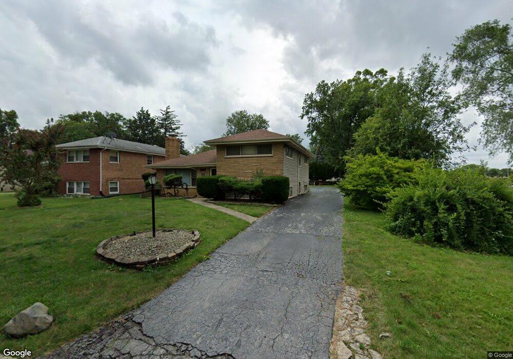
17100 Whittier Ave Hazel Crest, IL 60429
Estimated Value: $180,000 - $233,000
3
Beds
2
Baths
1,254
Sq Ft
$165/Sq Ft
Est. Value
About This Home
This home is located at 17100 Whittier Ave, Hazel Crest, IL 60429 and is currently estimated at $206,960, approximately $165 per square foot. 17100 Whittier Ave is a home located in Cook County with nearby schools including Mae Jemison School, Prairie-Hills Junior High School, and Hillcrest High School.
Ownership History
Date
Name
Owned For
Owner Type
Purchase Details
Closed on
Sep 3, 2024
Sold by
Pate Clarence and Pate Susan A
Bought by
White Arial R and White Alvin
Current Estimated Value
Home Financials for this Owner
Home Financials are based on the most recent Mortgage that was taken out on this home.
Original Mortgage
$127,645
Outstanding Balance
$126,087
Interest Rate
7.25%
Mortgage Type
FHA
Estimated Equity
$80,873
Create a Home Valuation Report for This Property
The Home Valuation Report is an in-depth analysis detailing your home's value as well as a comparison with similar homes in the area
Home Values in the Area
Average Home Value in this Area
Purchase History
| Date | Buyer | Sale Price | Title Company |
|---|---|---|---|
| White Arial R | $130,000 | Fidelity National Title |
Source: Public Records
Mortgage History
| Date | Status | Borrower | Loan Amount |
|---|---|---|---|
| Open | White Arial R | $127,645 |
Source: Public Records
Tax History
| Year | Tax Paid | Tax Assessment Tax Assessment Total Assessment is a certain percentage of the fair market value that is determined by local assessors to be the total taxable value of land and additions on the property. | Land | Improvement |
|---|---|---|---|---|
| 2025 | -- | $19,000 | $2,145 | $16,855 |
| 2024 | -- | $19,000 | $2,145 | $16,855 |
| 2023 | -- | $19,000 | $2,145 | $16,855 |
| 2022 | $0 | $12,135 | $1,815 | $10,320 |
| 2021 | $2,656 | $12,135 | $1,815 | $10,320 |
| 2020 | $2,656 | $12,135 | $1,815 | $10,320 |
| 2019 | $0 | $10,672 | $1,650 | $9,022 |
| 2018 | $0 | $10,672 | $1,650 | $9,022 |
| 2017 | $0 | $10,672 | $1,650 | $9,022 |
| 2016 | $0 | $10,036 | $1,485 | $8,551 |
| 2015 | $2,656 | $10,036 | $1,485 | $8,551 |
| 2014 | $2,937 | $10,036 | $1,485 | $8,551 |
| 2013 | $1,737 | $11,600 | $1,485 | $10,115 |
Source: Public Records
Map
Nearby Homes
- 17120 Whittier Ave
- 17107 California Ave
- 2904 Woodworth Place
- 17006 Novak Dr Unit T107
- 3012 171st St Unit GT
- 2817 173rd St
- 17005 Albany Ave Unit 102
- 3004 Longfellow Ave
- 3107 173rd St
- 3100 Longfellow Ave
- 3124 173rd St
- 17410 Emerson Ave
- 2900 175th St
- 3107 Longfellow Ave
- 2912 175th St
- 17405 Longfellow Ave
- 3213 Woodworth Place
- 3214 Birchwood Dr
- 17417 Kedzie Ave
- 3312 Maple Ln
- 17104 Whittier Ave
- 17106 Whittier Ave
- 17101 Longfellow Ave
- 17103 Longfellow Ave
- 17108 Whittier Ave
- 17105 Longfellow Ave
- 17101 Whittier Ave
- 17110 Whittier Ave
- 17103 Whittier Ave
- 17107 Whittier Ave
- 17109 Longfellow Ave
- 17109 Whittier Ave
- 17112 Whittier Ave
- 17111 Whittier Ave
- 17111 Longfellow Ave
- 17114 Whittier Ave
- 17113 Whittier Ave
- 17100 Longfellow Ave
- 17115 Longfellow Ave
- 17104 California Ave
Your Personal Tour Guide
Ask me questions while you tour the home.