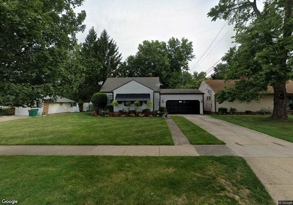
17101 Raymond St Maple Heights, OH 44137
Estimated Value: $106,316 - $127,000
3
Beds
1
Bath
1,058
Sq Ft
$109/Sq Ft
Est. Value
About This Home
This home is located at 17101 Raymond St, Maple Heights, OH 44137 and is currently estimated at $115,829, approximately $109 per square foot. 17101 Raymond St is a home located in Cuyahoga County with nearby schools including Abraham Lincoln Elementary School, Rockside/ J.F. Kennedy School, and Italy High School.
Ownership History
Date
Name
Owned For
Owner Type
Purchase Details
Closed on
Feb 22, 1988
Sold by
Gnatovich Dorothy M
Bought by
Wimbush Duane
Current Estimated Value
Purchase Details
Closed on
Sep 30, 1986
Sold by
Gnatovich Mike and Gnatovich Dorothy M
Bought by
Gnatovich Dorothy M
Purchase Details
Closed on
Oct 28, 1983
Sold by
Gnatovich Dorothy M
Bought by
Gnatovich Mike and Gnatovich Dorothy M
Purchase Details
Closed on
Jan 1, 1975
Bought by
Gnatovich Dorothy M
Create a Home Valuation Report for This Property
The Home Valuation Report is an in-depth analysis detailing your home's value as well as a comparison with similar homes in the area
Home Values in the Area
Average Home Value in this Area
Purchase History
| Date | Buyer | Sale Price | Title Company |
|---|---|---|---|
| Wimbush Duane | $47,900 | -- | |
| Gnatovich Dorothy M | -- | -- | |
| Gnatovich Mike | -- | -- | |
| Gnatovich Dorothy M | -- | -- |
Source: Public Records
Tax History Compared to Growth
Tax History
| Year | Tax Paid | Tax Assessment Tax Assessment Total Assessment is a certain percentage of the fair market value that is determined by local assessors to be the total taxable value of land and additions on the property. | Land | Improvement |
|---|---|---|---|---|
| 2024 | $3,550 | $38,500 | $9,975 | $28,525 |
| 2023 | $2,397 | $21,390 | $6,060 | $15,330 |
| 2022 | $2,389 | $21,390 | $6,060 | $15,330 |
| 2021 | $2,539 | $21,390 | $6,060 | $15,330 |
| 2020 | $2,186 | $16,210 | $4,590 | $11,620 |
| 2019 | $2,167 | $46,300 | $13,100 | $33,200 |
| 2018 | $1,078 | $16,210 | $4,590 | $11,620 |
| 2017 | $1,888 | $13,380 | $4,240 | $9,140 |
| 2016 | $1,821 | $13,380 | $4,240 | $9,140 |
| 2015 | $1,806 | $13,380 | $4,240 | $9,140 |
| 2014 | $1,806 | $14,710 | $4,660 | $10,050 |
Source: Public Records
Map
Nearby Homes
- 5082 Philip Ave
- 5110 Philip Ave
- 5061 Philip Ave
- 5185 Clement Ave
- 5208 Clement Ave
- 5210 Theodore St
- 16712 Kollin Ave
- 5212 Catherine St
- 5231 Philip Ave
- 5031 Cato St
- 16241 Glenburn Ave
- 5257 Philip Ave
- 5320 Clement Ave
- 5199 Arch St
- 5247 Henry St
- 5239 Arch St
- 15911 Friend Ave
- 5234 Erwin St
- 17204 Maple Heights Blvd
- 16312 Sunny Glenn Ave
- 17111 Raymond St
- 17001 Raymond St
- 5045 Anthony St
- 5080 Clement Ave
- 5068 Clement Ave
- 5101 Anthony St
- 5035 Anthony St
- 5100 Clement Ave
- 5064 Clement Ave
- 5103 Anthony St
- 5104 Clement Ave
- 16921 Raymond St
- 5025 Anthony St
- 5105 Anthony St
- 5050 Anthony St
- 5060 Clement Ave
- 5108 Clement Ave
- 5040 Anthony St
- 5109 Anthony St
- 5019 Anthony St