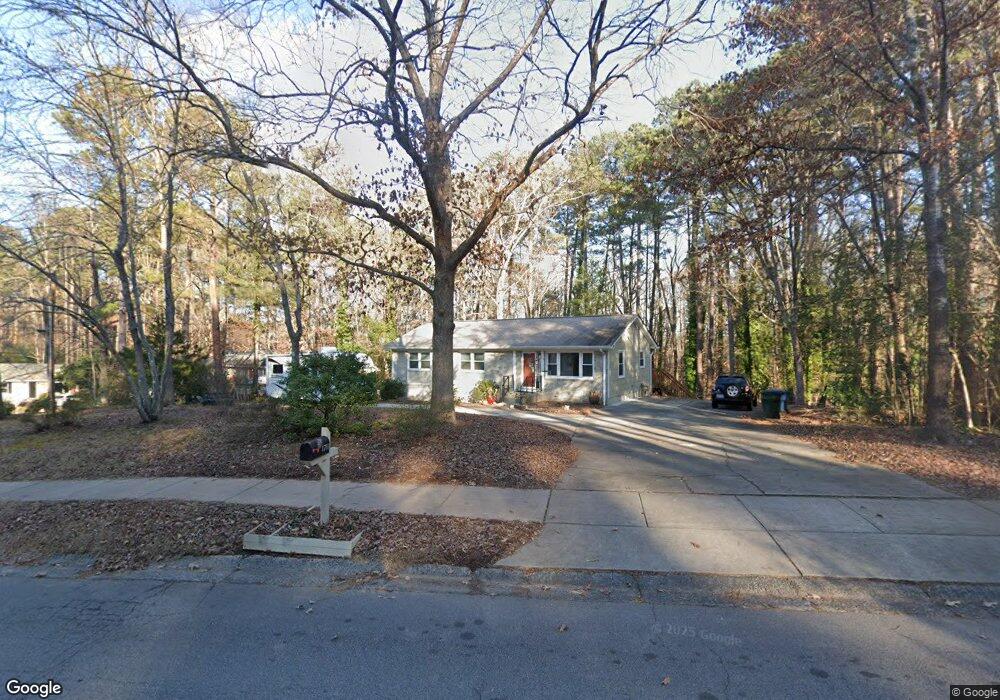
1711 Euclid Rd Durham, NC 27713
Estimated Value: $379,000 - $436,000
4
Beds
2
Baths
1,291
Sq Ft
$315/Sq Ft
Est. Value
About This Home
This home is located at 1711 Euclid Rd, Durham, NC 27713 and is currently estimated at $406,497, approximately $314 per square foot. 1711 Euclid Rd is a home located in Durham County with nearby schools including Parkwood Elementary, Lowe's Grove Middle, and Hillside High School.
Ownership History
Date
Name
Owned For
Owner Type
Purchase Details
Closed on
Feb 9, 2012
Sold by
Bolinger Timothy Reid and Bolinger Robert William
Bought by
Wilson Sandra Lee
Current Estimated Value
Home Financials for this Owner
Home Financials are based on the most recent Mortgage that was taken out on this home.
Original Mortgage
$138,400
Outstanding Balance
$96,439
Interest Rate
4.25%
Mortgage Type
FHA
Estimated Equity
$310,058
Create a Home Valuation Report for This Property
The Home Valuation Report is an in-depth analysis detailing your home's value as well as a comparison with similar homes in the area
Purchase History
| Date | Buyer | Sale Price | Title Company |
|---|---|---|---|
| Wilson Sandra Lee | $142,000 | None Available |
Source: Public Records
Mortgage History
| Date | Status | Borrower | Loan Amount |
|---|---|---|---|
| Open | Wilson Sandra Lee | $138,400 |
Source: Public Records
Tax History
| Year | Tax Paid | Tax Assessment Tax Assessment Total Assessment is a certain percentage of the fair market value that is determined by local assessors to be the total taxable value of land and additions on the property. | Land | Improvement |
|---|---|---|---|---|
| 2025 | $3,799 | $383,248 | $152,000 | $231,248 |
| 2024 | $3,205 | $229,757 | $45,630 | $184,127 |
| 2023 | $3,010 | $229,757 | $45,630 | $184,127 |
| 2022 | $2,941 | $229,757 | $45,630 | $184,127 |
| 2021 | $2,927 | $229,757 | $45,630 | $184,127 |
| 2020 | $2,858 | $229,757 | $45,630 | $184,127 |
| 2019 | $2,858 | $229,757 | $45,630 | $184,127 |
| 2018 | $2,057 | $151,623 | $41,827 | $109,796 |
| 2017 | $2,042 | $151,623 | $41,827 | $109,796 |
| 2016 | $1,973 | $151,623 | $41,827 | $109,796 |
| 2015 | $2,294 | $165,720 | $47,718 | $118,002 |
| 2014 | $2,294 | $165,720 | $47,718 | $118,002 |
Source: Public Records
Map
Nearby Homes
- 7 Travis Cir
- 1509 Clermont Rd Unit T27
- 1509 Clermont Rd Unit T24
- 1621 Clermont Rd
- 1215 Lotus Lilly Dr
- 1203 Lotus Lilly Dr
- 1027 Orchard Grass Rd
- 1022 Orchard Grass Rd
- 1208 Catch Fly Ln
- 1142 Metropolitan Dr
- 27 Sunflower Ct
- 1039 Laceflower Dr
- 1038 Laceflower Dr
- 1049 Laceflower Dr
- 1107 Rocketcress Dr
- 111 Wenonah Way
- 1019 Catch Fly Ln
- 1101 Canary Pepper Dr
- 6500 Amber Springs Dr
- 6519 Amber Springs Dr
- 1713 Euclid Rd
- 7 Custer Cir
- 1715 Euclid Rd
- 1712 Euclid Rd
- 1710 Euclid Rd
- 5 Custer Cir
- 1706 Euclid Rd
- 1714 Euclid Rd
- 1717 Euclid Rd
- 3 Custer Cir
- 1702 Euclid Rd
- 1716 Euclid Rd
- 1 Custer Cir
- 1719 Euclid Rd
- 4705 Brentwood Rd
- 1718 Euclid Rd
- 4707 Brentwood Rd
- 1721 Euclid Rd
- 1720 Euclid Rd
- 4709 Brentwood Rd
Your Personal Tour Guide
Ask me questions while you tour the home.