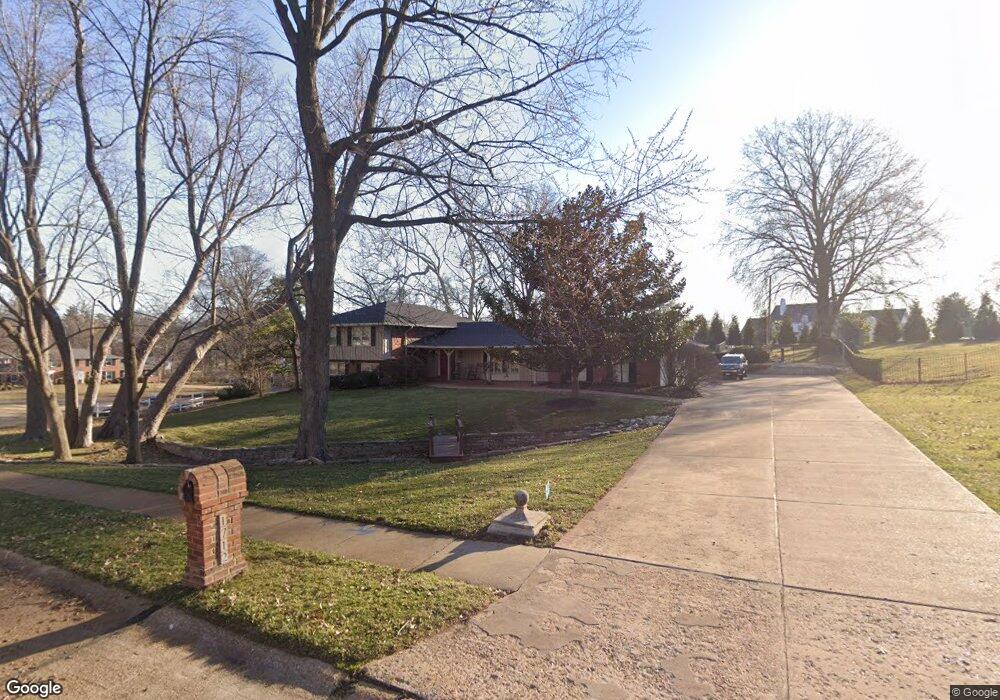
1712 Dunmorr Dr Saint Louis, MO 63131
Estimated Value: $923,000 - $1,157,298
5
Beds
5
Baths
4,025
Sq Ft
$257/Sq Ft
Est. Value
About This Home
This home is located at 1712 Dunmorr Dr, Saint Louis, MO 63131 and is currently estimated at $1,032,825, approximately $256 per square foot. 1712 Dunmorr Dr is a home located in St. Louis County with nearby schools including Westchester Elementary School, North Kirkwood Middle School, and Kirkwood Senior High School.
Ownership History
Date
Name
Owned For
Owner Type
Purchase Details
Closed on
Jul 13, 2020
Sold by
Dothage Alan L and Dothage Theresa M
Bought by
Dothage Alan L and Alan L Dothage Revocable Trust
Current Estimated Value
Purchase Details
Closed on
Aug 12, 2010
Sold by
Dothage Alan L
Bought by
Dothage Alan L and Dothage Theresa M
Purchase Details
Closed on
Sep 30, 2009
Sold by
Dalan Lawrence D
Bought by
Dothage Alan L
Home Financials for this Owner
Home Financials are based on the most recent Mortgage that was taken out on this home.
Original Mortgage
$404,000
Outstanding Balance
$264,881
Interest Rate
5.16%
Mortgage Type
New Conventional
Estimated Equity
$767,944
Purchase Details
Closed on
Jun 15, 2009
Sold by
Dalan Lynette D and Dalan Lawrence D
Bought by
Dalan Lawrence D
Create a Home Valuation Report for This Property
The Home Valuation Report is an in-depth analysis detailing your home's value as well as a comparison with similar homes in the area
Home Values in the Area
Average Home Value in this Area
Purchase History
| Date | Buyer | Sale Price | Title Company |
|---|---|---|---|
| Dothage Alan L | -- | None Available | |
| Dothage Alan L | -- | None Available | |
| Dothage Alan L | $505,000 | None Available | |
| Dalan Lawrence D | -- | None Available |
Source: Public Records
Mortgage History
| Date | Status | Borrower | Loan Amount |
|---|---|---|---|
| Open | Dothage Alan L | $404,000 |
Source: Public Records
Tax History Compared to Growth
Tax History
| Year | Tax Paid | Tax Assessment Tax Assessment Total Assessment is a certain percentage of the fair market value that is determined by local assessors to be the total taxable value of land and additions on the property. | Land | Improvement |
|---|---|---|---|---|
| 2025 | $8,418 | $168,400 | $79,800 | $88,600 |
| 2024 | $8,418 | $145,700 | $64,850 | $80,850 |
| 2023 | $8,288 | $145,700 | $64,850 | $80,850 |
| 2022 | $7,861 | $128,800 | $64,850 | $63,950 |
| 2021 | $7,776 | $128,800 | $64,850 | $63,950 |
| 2020 | $7,497 | $119,380 | $38,570 | $80,810 |
| 2019 | $7,507 | $119,380 | $38,570 | $80,810 |
| 2018 | $7,402 | $105,620 | $29,050 | $76,570 |
| 2017 | $7,422 | $105,620 | $29,050 | $76,570 |
| 2016 | $7,700 | $111,020 | $29,050 | $81,970 |
| 2015 | $7,710 | $111,020 | $29,050 | $81,970 |
| 2014 | $6,922 | $97,380 | $29,150 | $68,230 |
Source: Public Records
Map
Nearby Homes
- 12439 Springdale Ln Unit TBB
- 8 Briarbrook Trail
- The Hawthorne Plan at Ballas Ridge
- The Roclare II Plan at Ballas Ridge
- The Westchester IV Plan at Ballas Ridge
- The Nottingham II Plan at Ballas Ridge
- The Hawthorne II Plan at Ballas Ridge
- TBB
- TBB Ballas Ridge Roclare II
- TBB Ballas Ridge Hawthorne II
- TBB Ballas Ridge Westchester IV
- TBB
- 2056 N Ballas Rd
- 2062 N Ballas Rd
- 1090 Kinstern Dr
- 1126 Bopp Rd
- 1029 Kinstern Dr
- 1728 Folkstone Dr
- 723 Oak Valley Dr
- 1741 Pine Hill Dr
- 1700 Dunmorr Dr
- 12126 Creekhaven Dr
- 12301 Federal Dr
- 12310 Creekhaven Dr
- 1656 Dunmorr Dr
- 12112 Creekhaven Dr
- 1661 Dunmorr Dr
- 12131 Creekhaven Dr
- 12315 Federal Dr
- 1644 Dunmorr Dr
- 12328 Creekhaven Dr
- 7 Claychester Dr
- 12311 Creekhaven Dr
- 12117 Creekhaven Dr
- 6 Claychester Dr
- 12100 Creekhaven Dr
- 12314 Federal Dr
- 12301 Wedgeton Ln
- 12327 Creekhaven Dr
- 12105 Creekhaven Dr