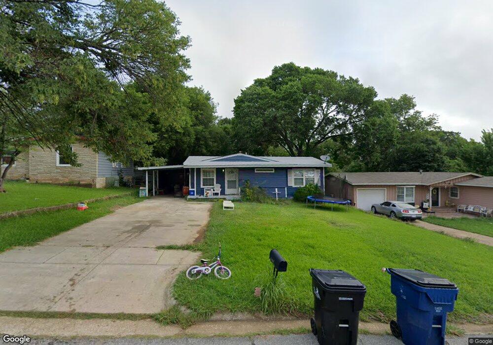
1713 Mockingbird Ln Denison, TX 75020
Estimated Value: $119,621 - $142,000
3
Beds
1
Bath
814
Sq Ft
$161/Sq Ft
Est. Value
About This Home
This home is located at 1713 Mockingbird Ln, Denison, TX 75020 and is currently estimated at $130,811, approximately $160 per square foot. 1713 Mockingbird Ln is a home located in Grayson County with nearby schools including Mayes Elementary School, Scott Middle School, and Denison High School.
Ownership History
Date
Name
Owned For
Owner Type
Purchase Details
Closed on
Jan 4, 2011
Sold by
Deutsche Bank National Trust Company
Bought by
Wilkerson Ronald
Current Estimated Value
Purchase Details
Closed on
Nov 14, 2010
Sold by
Halderman Sasha Renee and Hancock Christopher Scott
Bought by
Deutsche Bank National Trust Company
Purchase Details
Closed on
Nov 11, 2005
Sold by
House Vera Marie and Keown Colin F
Bought by
Hancock Christopher Scott and Halderman Sasha Renee
Home Financials for this Owner
Home Financials are based on the most recent Mortgage that was taken out on this home.
Original Mortgage
$10,000
Interest Rate
6.04%
Mortgage Type
Stand Alone Second
Create a Home Valuation Report for This Property
The Home Valuation Report is an in-depth analysis detailing your home's value as well as a comparison with similar homes in the area
Home Values in the Area
Average Home Value in this Area
Purchase History
| Date | Buyer | Sale Price | Title Company |
|---|---|---|---|
| Wilkerson Ronald | -- | Lsi Title Agency Inc | |
| Deutsche Bank National Trust Company | $26,819 | None Available | |
| Hancock Christopher Scott | -- | -- |
Source: Public Records
Mortgage History
| Date | Status | Borrower | Loan Amount |
|---|---|---|---|
| Previous Owner | Hancock Christopher Scott | $10,000 | |
| Previous Owner | Hancock Christopher Scott | $40,000 |
Source: Public Records
Tax History
| Year | Tax Paid | Tax Assessment Tax Assessment Total Assessment is a certain percentage of the fair market value that is determined by local assessors to be the total taxable value of land and additions on the property. | Land | Improvement |
|---|---|---|---|---|
| 2025 | $2,568 | $109,231 | $43,992 | $65,239 |
| 2024 | $2,568 | $110,514 | $47,892 | $62,622 |
| 2023 | $2,269 | $100,152 | $41,808 | $58,344 |
| 2022 | $2,240 | $94,259 | $41,808 | $52,451 |
| 2021 | $1,674 | $66,389 | $21,684 | $44,705 |
| 2020 | $1,580 | $59,891 | $15,288 | $44,603 |
| 2019 | $1,653 | $60,082 | $12,714 | $47,368 |
| 2018 | $1,398 | $50,393 | $8,112 | $42,281 |
| 2017 | $1,316 | $47,024 | $7,176 | $39,848 |
| 2016 | $1,054 | $37,670 | $9,500 | $28,170 |
Source: Public Records
Map
Nearby Homes
- 1140 Redbud St
- 1725 Meadowlark Ln
- 1201 Ridgewood Rd
- 1737 W Parnell St
- 1716 N Ridgewood Dr
- 2425 Juanita Dr
- 1728 W Washington St
- 816 Leeper Dr
- 2151 Juanita Dr
- 1505 W Johnson St
- 501 W Walker St
- 909 W Walker St
- TBD W Johnson St
- 611 W Johnson St
- 1801 W Bond St
- 2021 W Walker St
- 1905 W Morton St Unit 5
- 1905 W Morton St Unit 6
- 1905 W Morton St Unit 16
- 2003 W Bond St
- 1717 Mockingbird Ln
- 1709 Mockingbird Ln
- 1721 Mockingbird Ln
- 1705 Mockingbird Ln
- 1712 Meadowlark Ln
- 1716 Meadowlark Ln
- 1708 Meadowlark Ln
- 1720 Meadowlark Ln
- 1727 Mockingbird Ln
- 1704 Meadowlark Ln
- 1712 Mockingbird Ln
- 1716 Mockingbird Ln
- 1704 Mockingbird Ln
- 1130 Ridgewood Rd
- 1701 Mockingbird Ln
- 1724 Meadowlark Ln
- 1801 Mockingbird Ln
- 1700 Meadowlark Ln
- 1800 Meadowlark Ln
- 1133 Redbud St
Your Personal Tour Guide
Ask me questions while you tour the home.