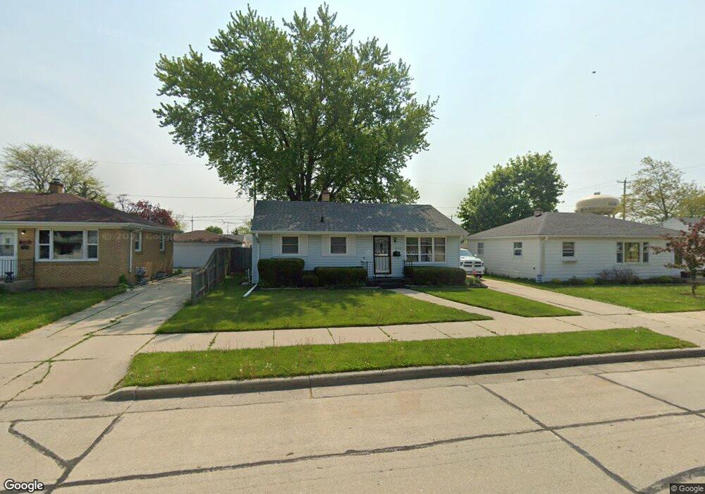
1713 Polaris Ave Racine, WI 53404
Wustum Park NeighborhoodEstimated Value: $196,000 - $219,000
3
Beds
1
Bath
949
Sq Ft
$218/Sq Ft
Est. Value
About This Home
This home is located at 1713 Polaris Ave, Racine, WI 53404 and is currently estimated at $207,070, approximately $218 per square foot. 1713 Polaris Ave is a home located in Racine County with nearby schools including Wadewitz Elementary School, Jerstad-Agerholm Middle School, and Horlick High School.
Ownership History
Date
Name
Owned For
Owner Type
Purchase Details
Closed on
Sep 4, 2020
Sold by
Slater Scott D and Slater Christine M
Bought by
Hernando Imelda and Munoz Hector
Current Estimated Value
Home Financials for this Owner
Home Financials are based on the most recent Mortgage that was taken out on this home.
Original Mortgage
$134,800
Outstanding Balance
$119,626
Interest Rate
2.9%
Mortgage Type
New Conventional
Estimated Equity
$87,444
Create a Home Valuation Report for This Property
The Home Valuation Report is an in-depth analysis detailing your home's value as well as a comparison with similar homes in the area
Home Values in the Area
Average Home Value in this Area
Purchase History
| Date | Buyer | Sale Price | Title Company |
|---|---|---|---|
| Hernando Imelda | $139,000 | Travelers Title Llc |
Source: Public Records
Mortgage History
| Date | Status | Borrower | Loan Amount |
|---|---|---|---|
| Open | Hernando Imelda | $134,800 |
Source: Public Records
Tax History Compared to Growth
Tax History
| Year | Tax Paid | Tax Assessment Tax Assessment Total Assessment is a certain percentage of the fair market value that is determined by local assessors to be the total taxable value of land and additions on the property. | Land | Improvement |
|---|---|---|---|---|
| 2024 | $3,623 | $158,200 | $18,400 | $139,800 |
| 2023 | $3,326 | $141,000 | $18,400 | $122,600 |
| 2022 | $3,062 | $128,000 | $18,400 | $109,600 |
| 2021 | $3,099 | $116,000 | $18,400 | $97,600 |
| 2020 | $3,107 | $116,000 | $18,400 | $97,600 |
| 2019 | $2,840 | $108,000 | $18,400 | $89,600 |
| 2018 | $2,769 | $93,000 | $18,400 | $74,600 |
| 2017 | $3,287 | $93,000 | $18,400 | $74,600 |
| 2016 | $3,182 | $88,000 | $18,400 | $69,600 |
| 2015 | $2,799 | $83,000 | $18,400 | $64,600 |
| 2014 | $2,799 | $83,000 | $18,400 | $64,600 |
| 2013 | $2,799 | $89,000 | $22,700 | $66,300 |
Source: Public Records
Map
Nearby Homes
- 1708 Shoop St
- 2009 Rapids Dr
- 1818 Neptune Ave
- 1626 Rapids Dr
- 2100 Carlisle Ave
- 1322 Summit Ave
- 2300 Rapids Dr
- 2123 Carlisle Ave
- 2210 Rapids Dr
- 1406 Blake Ave
- 2701 Rapids Dr
- 2600 W High St
- 2402 Eaton Ln
- 1927 Harriet St
- 1337 Kewaunee St
- 2400 Romayne Ave
- 1616 Dr Martin Luther King Dr
- 1228 English St
- 2525 Diane Ave
- 2525 Donna Ave
- 1709 Polaris Ave
- 1719 Polaris Ave
- 1712 Mount Pleasant St
- 1716 Mount Pleasant St
- 1725 Polaris Ave
- 1703 Polaris Ave
- 1706 Mount Pleasant St
- 1722 Mount Pleasant St
- 2104 High St
- 2104 High St
- 1731 Polaris Ave
- 1726 Mount Pleasant St
- 1710 Polaris Ave
- 1718 Polaris Ave
- 1702 Polaris Ave
- 1724 Polaris Ave
- 1732 Mount Pleasant St
- 1801 Polaris Ave
- 1730 Polaris Ave
- 1800 Mount Pleasant St