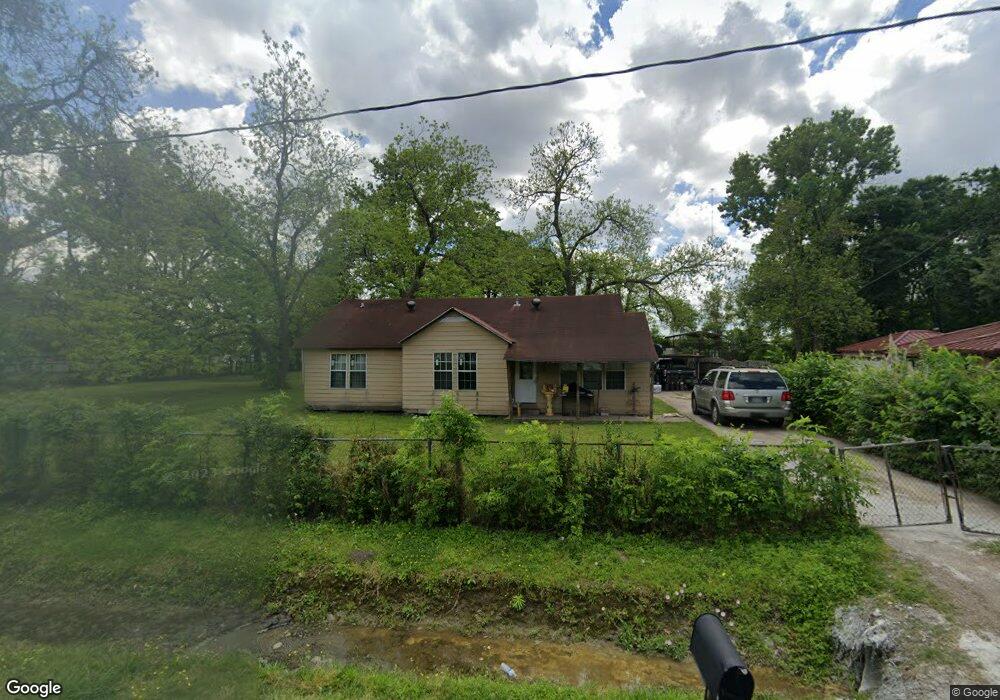
1714 Lone Oak Rd Houston, TX 77093
Estimated Value: $238,000 - $266,000
2
Beds
1
Bath
1,806
Sq Ft
$141/Sq Ft
Est. Value
About This Home
This home is located at 1714 Lone Oak Rd, Houston, TX 77093 and is currently estimated at $255,273, approximately $141 per square foot. 1714 Lone Oak Rd is a home located in Harris County with nearby schools including Barrick Elementary School, Patrick Henry Middle School, and Sam Houston Math, Science & Technology Center.
Ownership History
Date
Name
Owned For
Owner Type
Purchase Details
Closed on
Oct 20, 1997
Sold by
Taylor Carolyn and Halstead James Adolph
Bought by
Ramirez Guadalupe
Current Estimated Value
Home Financials for this Owner
Home Financials are based on the most recent Mortgage that was taken out on this home.
Original Mortgage
$43,000
Outstanding Balance
$6,951
Interest Rate
7.52%
Mortgage Type
Seller Take Back
Estimated Equity
$248,322
Create a Home Valuation Report for This Property
The Home Valuation Report is an in-depth analysis detailing your home's value as well as a comparison with similar homes in the area
Home Values in the Area
Average Home Value in this Area
Purchase History
| Date | Buyer | Sale Price | Title Company |
|---|---|---|---|
| Ramirez Guadalupe | -- | American Title Company |
Source: Public Records
Mortgage History
| Date | Status | Borrower | Loan Amount |
|---|---|---|---|
| Open | Ramirez Guadalupe | $43,000 |
Source: Public Records
Tax History Compared to Growth
Tax History
| Year | Tax Paid | Tax Assessment Tax Assessment Total Assessment is a certain percentage of the fair market value that is determined by local assessors to be the total taxable value of land and additions on the property. | Land | Improvement |
|---|---|---|---|---|
| 2025 | $2,201 | $212,248 | $100,181 | $112,067 |
| 2024 | $2,201 | $212,248 | $100,181 | $112,067 |
| 2023 | $2,201 | $195,973 | $100,181 | $95,792 |
| 2022 | $3,391 | $195,973 | $100,181 | $95,792 |
| 2021 | $3,273 | $176,902 | $100,181 | $76,721 |
| 2020 | $3,095 | $176,902 | $100,181 | $76,721 |
| 2019 | $2,935 | $176,902 | $100,181 | $76,721 |
| 2018 | $1,895 | $124,567 | $66,788 | $57,779 |
| 2017 | $2,668 | $124,567 | $66,788 | $57,779 |
| 2016 | $2,668 | $124,567 | $66,788 | $57,779 |
| 2015 | $2,016 | $124,567 | $66,788 | $57,779 |
| 2014 | $2,016 | $124,567 | $66,788 | $57,779 |
Source: Public Records
Map
Nearby Homes
- 1802 Kowis St
- 1908 Little York Rd
- 1930 Cromwell St
- 2122 Kowis St
- 2152 William Tell St
- 2131 Cromwell St Unit D
- 1829 Skinner Rd
- 2131 Warwick Rd
- 2123 Warwick Rd
- 10022 E Hardy Rd
- 1508 Hopper Rd Unit 1
- 10514 Exeter St
- 10512 Exeter St
- 2237 Cromwell St
- 1925 Sunny Dr
- 1703 & 0 Sunny Dr
- 11110 E Hardy Rd
- 2306 Wardmont St
- 2311 Warwick Rd
- 2315 Langley Rd
- 1712 Lone Oak Rd
- 1717 Lone Oak Rd
- 1720 Lone Oak Rd
- 1709 Lone Oak Rd
- 1723 Lone Oak Rd
- 1702 Lone Oak Rd
- 10824 Exeter St
- 1729 Lone Oak Rd
- 10820 Exeter St
- 1728 Lone Oak Rd
- 1701 Lone Oak Rd
- 1730 Lone Oak Rd
- 1818 Lone Oak Rd Unit 1818
- 1620 Lone Oak Rd
- 1800 Lone Oak Rd
- 1822 Kowis St
- 1818 Kowis St
- 1826 Kowis St
- 1814 Kowis St
- 1830 Kowis St