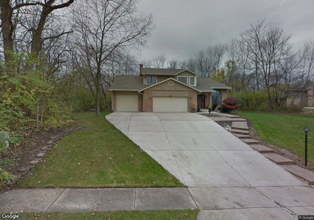
1715 Birnam Wood Ct Vandalia, OH 45377
Estimated Value: $493,000 - $604,000
5
Beds
4
Baths
4,050
Sq Ft
$135/Sq Ft
Est. Value
About This Home
This home is located at 1715 Birnam Wood Ct, Vandalia, OH 45377 and is currently estimated at $547,084, approximately $135 per square foot. 1715 Birnam Wood Ct is a home located in Montgomery County with nearby schools including Demmitt Elementary School, Smith Middle School, and Butler High School.
Ownership History
Date
Name
Owned For
Owner Type
Purchase Details
Closed on
Jul 22, 2016
Sold by
Sanders Jeffery H and Sanders Margaret
Bought by
Mcgowan Ii Robert A
Current Estimated Value
Home Financials for this Owner
Home Financials are based on the most recent Mortgage that was taken out on this home.
Original Mortgage
$297,801
Outstanding Balance
$237,888
Interest Rate
3.6%
Mortgage Type
VA
Estimated Equity
$309,196
Purchase Details
Closed on
Oct 19, 2001
Sold by
Kong Roberto M and Kong Honeylyn P
Bought by
Sanders Jeffrey H and Sanders Margaret
Home Financials for this Owner
Home Financials are based on the most recent Mortgage that was taken out on this home.
Original Mortgage
$186,300
Interest Rate
6.92%
Purchase Details
Closed on
Mar 20, 1997
Sold by
Zalar Karl P and Faruki Michelle F
Bought by
Kong Roberto M and Kong Honeylyn P
Create a Home Valuation Report for This Property
The Home Valuation Report is an in-depth analysis detailing your home's value as well as a comparison with similar homes in the area
Home Values in the Area
Average Home Value in this Area
Purchase History
| Date | Buyer | Sale Price | Title Company |
|---|---|---|---|
| Mcgowan Ii Robert A | $310,000 | M & M Title Co | |
| Sanders Jeffrey H | $232,900 | -- | |
| Kong Roberto M | $189,500 | -- |
Source: Public Records
Mortgage History
| Date | Status | Borrower | Loan Amount |
|---|---|---|---|
| Open | Mcgowan Ii Robert A | $297,801 | |
| Previous Owner | Sanders Jeffrey H | $186,300 |
Source: Public Records
Tax History Compared to Growth
Tax History
| Year | Tax Paid | Tax Assessment Tax Assessment Total Assessment is a certain percentage of the fair market value that is determined by local assessors to be the total taxable value of land and additions on the property. | Land | Improvement |
|---|---|---|---|---|
| 2024 | $7,433 | $142,870 | $23,630 | $119,240 |
| 2023 | $7,433 | $142,870 | $23,630 | $119,240 |
| 2022 | $6,808 | $105,830 | $17,500 | $88,330 |
| 2021 | $6,814 | $105,830 | $17,500 | $88,330 |
| 2020 | $6,794 | $105,830 | $17,500 | $88,330 |
| 2019 | $6,924 | $98,870 | $17,500 | $81,370 |
| 2018 | $6,937 | $98,870 | $17,500 | $81,370 |
| 2017 | $6,885 | $98,870 | $17,500 | $81,370 |
| 2016 | $6,093 | $85,970 | $17,500 | $68,470 |
| 2015 | $6,017 | $85,970 | $17,500 | $68,470 |
| 2014 | $6,017 | $85,970 | $17,500 | $68,470 |
| 2012 | -- | $79,560 | $17,500 | $62,060 |
Source: Public Records
Map
Nearby Homes
- 469 Farrell Rd
- 416 Bent Twig Dr
- 1441 S Dixie Dr
- 770 Deer Creek Dr
- 3518 Park Crest Ln
- 461 Poplar Grove Dr
- 847 Waldsmith Way
- 1515 Ash Ridge Ct
- 246 Crest Hill Ave
- 668 Deerhurst Dr
- 678 Deerhurst Dr
- Fairfax Plan at Foxfire - Maple Street Collection
- Yosemite Plan at Foxfire - Maple Street Collection
- Cumberland Plan at Foxfire - Maple Street Collection
- Jensen Plan at Foxfire - Maple Street Collection
- Beacon Plan at Foxfire - Maple Street Collection
- Wesley Plan at Foxfire - Maple Street Collection
- Breckenridge Plan at Foxfire - Maple Street Collection
- Danville Plan at Foxfire - Maple Street Collection
- DaVinci Plan at Foxfire - Maple Street Collection
- 340 Timberwind Ln
- 320 Timberwind Ln
- 300 Timberwind Ln
- 1710 Birnam Wood Ct
- 1720 Cawdor Ct
- 400 Timberwind Ln
- 1700 Cawdor Ct
- 365 Timberwind Ln
- 345 Timberwind Ln
- 401 Timberwind Ln
- 406 Timberwind Ln
- 325 Timberwind Ln
- 407 Timberwind Ln
- 305 Timberwind Ln
- 410 Timberwind Ln
- 415 Timberwind Ln
- 1701 Cawdor Ct
- 1725 Cawdor Ct
- 1640 Carolina Dr
- 427 Timberwind Ln