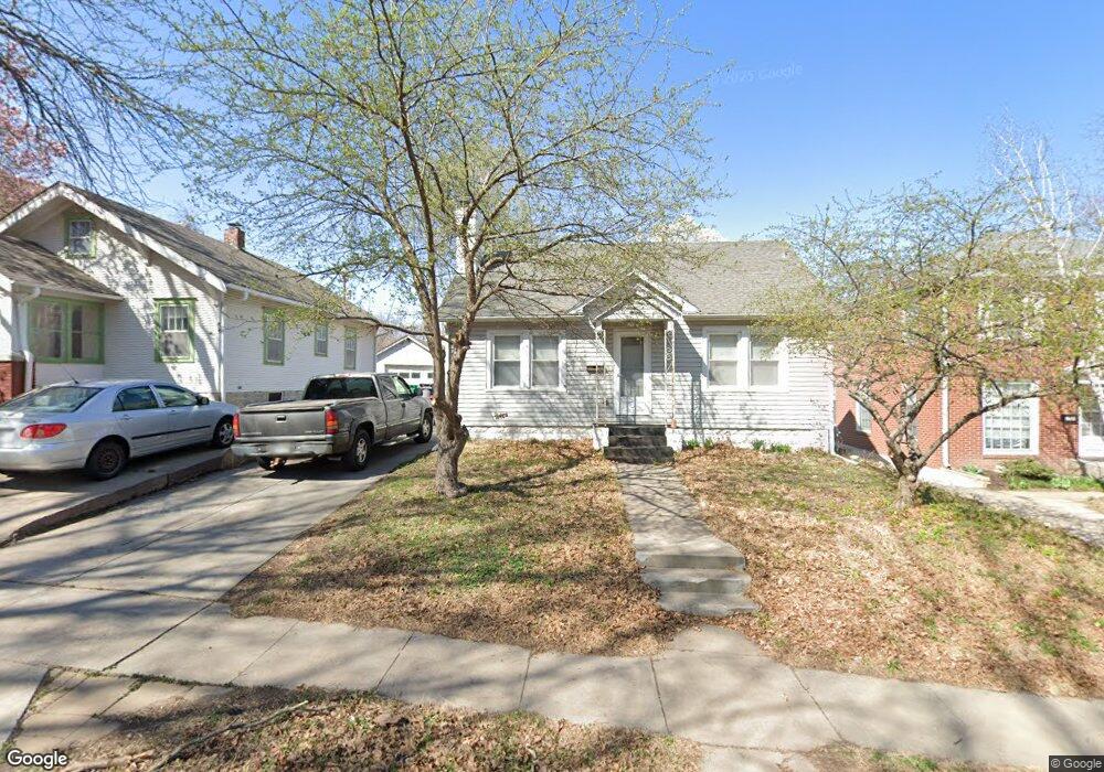
1716 High St Lincoln, NE 68502
Indian Village NeighborhoodEstimated Value: $197,608 - $242,000
2
Beds
2
Baths
1,170
Sq Ft
$181/Sq Ft
Est. Value
About This Home
This home is located at 1716 High St, Lincoln, NE 68502 and is currently estimated at $212,152, approximately $181 per square foot. 1716 High St is a home located in Lancaster County with nearby schools including Beattie Elementary School, Irving Middle School, and Lincoln Southeast High School.
Ownership History
Date
Name
Owned For
Owner Type
Purchase Details
Closed on
Apr 30, 2008
Sold by
Schulz Sean Michael Gustov and Stohlman Corrie L
Bought by
Lyons Andrew L
Current Estimated Value
Purchase Details
Closed on
Aug 13, 2003
Sold by
Neal Sean M
Bought by
Neal Sean M and Stohlman Corrie L
Home Financials for this Owner
Home Financials are based on the most recent Mortgage that was taken out on this home.
Original Mortgage
$88,650
Interest Rate
7.85%
Mortgage Type
New Conventional
Purchase Details
Closed on
Jun 16, 1999
Sold by
Miller Virginia
Bought by
Neal Sean M
Home Financials for this Owner
Home Financials are based on the most recent Mortgage that was taken out on this home.
Original Mortgage
$43,800
Interest Rate
7.02%
Create a Home Valuation Report for This Property
The Home Valuation Report is an in-depth analysis detailing your home's value as well as a comparison with similar homes in the area
Home Values in the Area
Average Home Value in this Area
Purchase History
| Date | Buyer | Sale Price | Title Company |
|---|---|---|---|
| Lyons Andrew L | $55,000 | Utc | |
| Neal Sean M | -- | Lts Title Services | |
| Neal Sean M | $62,000 | -- |
Source: Public Records
Mortgage History
| Date | Status | Borrower | Loan Amount |
|---|---|---|---|
| Previous Owner | Neal Sean M | $88,650 | |
| Previous Owner | Neal Sean M | $43,800 | |
| Closed | Neal Sean M | $20,000 |
Source: Public Records
Tax History Compared to Growth
Tax History
| Year | Tax Paid | Tax Assessment Tax Assessment Total Assessment is a certain percentage of the fair market value that is determined by local assessors to be the total taxable value of land and additions on the property. | Land | Improvement |
|---|---|---|---|---|
| 2025 | $2,480 | $188,800 | $54,000 | $134,800 |
| 2024 | $2,480 | $176,700 | $45,000 | $131,700 |
| 2023 | $2,720 | $162,300 | $45,000 | $117,300 |
| 2022 | $2,513 | $126,100 | $35,000 | $91,100 |
| 2021 | $2,378 | $126,100 | $35,000 | $91,100 |
| 2020 | $2,125 | $111,200 | $35,000 | $76,200 |
| 2019 | $2,125 | $111,200 | $35,000 | $76,200 |
| 2018 | $1,910 | $99,500 | $35,000 | $64,500 |
| 2017 | $1,927 | $99,500 | $35,000 | $64,500 |
| 2016 | $1,877 | $96,400 | $30,000 | $66,400 |
| 2015 | $1,864 | $96,400 | $30,000 | $66,400 |
| 2014 | $1,735 | $89,200 | $30,000 | $59,200 |
| 2013 | -- | $89,200 | $30,000 | $59,200 |
Source: Public Records
Map
Nearby Homes
- 3345 Grimsby Ln
- 1916 Pawnee St
- 1444 Dakota St
- 1605 Van Dorn St
- 3609 S 18th St
- 2810 S 14th St
- 3645 S 17th St
- 2934 S 13th St
- 1837 Harrison Ave
- 2760 S 13th St
- 2950 S 11th St
- 2500 Worthington Ave
- 2810 S 11th St
- 2610 S 13th St
- 1954 Lake St
- 2025 Lake St
- 2301 Smith St
- 1736 Sunny Hill Rd
- 1934 Park Ave
- 2601 Woodsdale Blvd