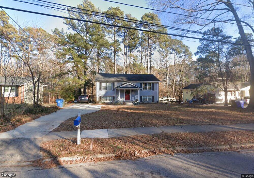
1717 Euclid Rd Durham, NC 27713
Estimated Value: $396,000 - $446,000
3
Beds
2
Baths
2,009
Sq Ft
$208/Sq Ft
Est. Value
About This Home
This home is located at 1717 Euclid Rd, Durham, NC 27713 and is currently estimated at $418,385, approximately $208 per square foot. 1717 Euclid Rd is a home located in Durham County with nearby schools including Parkwood Elementary, Lowe's Grove Middle, and Hillside High School.
Ownership History
Date
Name
Owned For
Owner Type
Purchase Details
Closed on
Mar 31, 2017
Sold by
Drury John
Bought by
Mcgee Chason C and Mcgee Ramona H
Current Estimated Value
Home Financials for this Owner
Home Financials are based on the most recent Mortgage that was taken out on this home.
Original Mortgage
$211,500
Outstanding Balance
$175,467
Interest Rate
4.1%
Mortgage Type
New Conventional
Estimated Equity
$242,918
Purchase Details
Closed on
Dec 9, 2016
Sold by
Gillespie Arthur Samuel
Bought by
Wodarz Corey and Drury John
Create a Home Valuation Report for This Property
The Home Valuation Report is an in-depth analysis detailing your home's value as well as a comparison with similar homes in the area
Purchase History
| Date | Buyer | Sale Price | Title Company |
|---|---|---|---|
| Mcgee Chason C | $235,000 | -- | |
| Wodarz Corey | $145,000 | -- |
Source: Public Records
Mortgage History
| Date | Status | Borrower | Loan Amount |
|---|---|---|---|
| Open | Mcgee Chason C | $211,500 |
Source: Public Records
Tax History
| Year | Tax Paid | Tax Assessment Tax Assessment Total Assessment is a certain percentage of the fair market value that is determined by local assessors to be the total taxable value of land and additions on the property. | Land | Improvement |
|---|---|---|---|---|
| 2025 | $4,199 | $423,553 | $129,000 | $294,553 |
| 2024 | $3,129 | $224,282 | $38,700 | $185,582 |
| 2023 | $2,938 | $224,282 | $38,700 | $185,582 |
| 2022 | $2,871 | $224,282 | $38,700 | $185,582 |
| 2021 | $2,857 | $224,282 | $38,700 | $185,582 |
| 2020 | $2,790 | $224,282 | $38,700 | $185,582 |
| 2019 | $2,790 | $224,282 | $38,700 | $185,582 |
| 2018 | $2,212 | $163,087 | $35,475 | $127,612 |
| 2017 | $1,897 | $140,870 | $35,475 | $105,395 |
| 2016 | $1,833 | $140,870 | $35,475 | $105,395 |
| 2015 | $1,838 | $132,801 | $25,980 | $106,821 |
| 2014 | $1,838 | $132,801 | $25,980 | $106,821 |
Source: Public Records
Map
Nearby Homes
- 7 Travis Cir
- 1509 Clermont Rd Unit T27
- 1509 Clermont Rd Unit T24
- 1621 Clermont Rd
- 1215 Lotus Lilly Dr
- 1203 Lotus Lilly Dr
- 27 Sunflower Ct
- 1027 Orchard Grass Rd
- 1022 Orchard Grass Rd
- 1208 Catch Fly Ln
- 111 Wenonah Way
- 1142 Metropolitan Dr
- 1039 Laceflower Dr
- 1038 Laceflower Dr
- 1049 Laceflower Dr
- 1107 Rocketcress Dr
- 1019 Catch Fly Ln
- 1101 Canary Pepper Dr
- 109 Settlers Mill Ln
- 6500 Amber Springs Dr
Your Personal Tour Guide
Ask me questions while you tour the home.