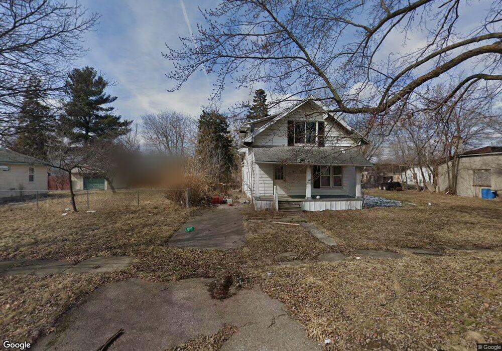
1717 N Cumberland St Flint, MI 48506
Eastside NeighborhoodEstimated Value: $28,000 - $47,000
3
Beds
1
Bath
1,348
Sq Ft
$28/Sq Ft
Est. Value
About This Home
This home is located at 1717 N Cumberland St, Flint, MI 48506 and is currently estimated at $37,500, approximately $27 per square foot. 1717 N Cumberland St is a home located in Genesee County with nearby schools including Potter School, Flint Cultural Center Academy, and WAY Academy of Flint.
Ownership History
Date
Name
Owned For
Owner Type
Purchase Details
Closed on
Sep 26, 2025
Sold by
Genesee County Land Bank Authority
Bought by
Starling Stanley
Current Estimated Value
Purchase Details
Closed on
Dec 17, 2015
Sold by
Genesee County
Bought by
Genesee County Land Bank
Purchase Details
Closed on
Oct 24, 2011
Sold by
Metcalfe William James
Bought by
Allen Randolph Reginald
Purchase Details
Closed on
Feb 8, 2007
Sold by
Federal Home Loan Mortgage Corp
Bought by
Metcalfe & Son
Purchase Details
Closed on
Jul 19, 2006
Sold by
Evans Isabelle J
Bought by
Federal Home Loan Mortgage Corp
Create a Home Valuation Report for This Property
The Home Valuation Report is an in-depth analysis detailing your home's value as well as a comparison with similar homes in the area
Home Values in the Area
Average Home Value in this Area
Purchase History
| Date | Buyer | Sale Price | Title Company |
|---|---|---|---|
| Starling Stanley | $1,000 | None Listed On Document | |
| Genesee County Land Bank | -- | None Available | |
| Allen Randolph Reginald | $1,600 | None Available | |
| Metcalfe & Son | $9,000 | First American Title Ins Co | |
| Federal Home Loan Mortgage Corp | $49,423 | None Available |
Source: Public Records
Tax History Compared to Growth
Tax History
| Year | Tax Paid | Tax Assessment Tax Assessment Total Assessment is a certain percentage of the fair market value that is determined by local assessors to be the total taxable value of land and additions on the property. | Land | Improvement |
|---|---|---|---|---|
| 2025 | -- | $0 | $0 | $0 |
| 2024 | -- | $0 | $0 | $0 |
| 2023 | -- | $0 | $0 | $0 |
| 2022 | $0 | $0 | $0 | $0 |
| 2021 | $0 | $0 | $0 | $0 |
| 2020 | $0 | $0 | $0 | $0 |
| 2019 | $0 | $0 | $0 | $0 |
| 2018 | $0 | $0 | $0 | $0 |
| 2017 | $0 | $0 | $0 | $0 |
| 2016 | $0 | $0 | $0 | $0 |
| 2015 | -- | $0 | $0 | $0 |
| 2014 | -- | $0 | $0 | $0 |
| 2012 | -- | $8,700 | $0 | $0 |
Source: Public Records
Map
Nearby Homes
- 1510 N Vernon Ave
- 2610 Pennsylvania Ave
- 1622 Arlington Ave
- 2426 Missouri Ave
- 2301 Missouri Ave
- 2211 Torrance St
- 1501 Arlington Ave
- 2605 Nebraska Ave
- 2426 Hoff St
- 2225 Arlington Ave
- 1318 Cronk Ave
- 1805 Bennett Ave
- 1814 Mabel Ave
- 2506 Arlington Ave
- 1644 Pennsylvania Ave
- 301 Chandler St
- 3205 Holly Ave
- 1605 Kearsley Park Blvd
- 3149 Whittier Ave
- 3116 Beechwood Ave
- 1709 N Cumberland St
- 2522 Davison Rd
- 2512 Davison Rd
- 1718 Levern St
- 1714 Levern St
- 1710 Levern St
- 1701 N Cumberland St
- 1706 Levern St
- 1722 N Cumberland St
- 1714 N Cumberland St
- 2602 Davison Rd
- 1702 Levern St
- 2601 Illinois Ave
- 2610 Davison Rd
- 1721 Levern St
- 2502 Illinois Ave
- 2419 Illinois Ave
- 1717 N Meade St
- 2414 Davison Rd
- 2506 Illinois Ave