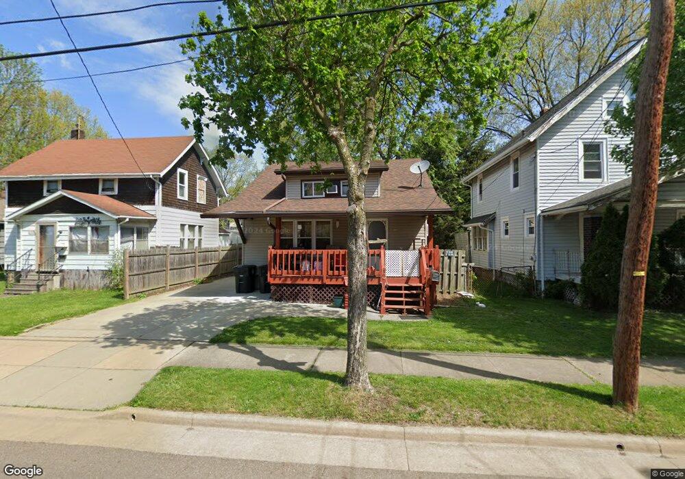
1717 Shaw Ave Akron, OH 44305
Goodyear Heights NeighborhoodEstimated Value: $114,000 - $148,000
4
Beds
2
Baths
1,210
Sq Ft
$107/Sq Ft
Est. Value
About This Home
This home is located at 1717 Shaw Ave, Akron, OH 44305 and is currently estimated at $129,397, approximately $106 per square foot. 1717 Shaw Ave is a home located in Summit County with nearby schools including Seiberling Community Learning Center, Akron Preparatory school, and Middlebury Academy.
Ownership History
Date
Name
Owned For
Owner Type
Purchase Details
Closed on
Mar 6, 2012
Sold by
Neiman Robert E and Neiman Robert E
Bought by
Smith Ruby M
Current Estimated Value
Purchase Details
Closed on
Jan 5, 2011
Sold by
Us Bank Na Nd
Bought by
Neiman Robert E and Robert E Neiman 401K #80504 Equity Trust
Purchase Details
Closed on
Nov 9, 2010
Sold by
Dennison Robert L and Dennison Dorothy J
Bought by
Us Bank Na Nd
Purchase Details
Closed on
Dec 2, 2008
Sold by
Dennison Robert L and Dennison Dorothy J
Bought by
Dennison Ii Robert L and Dennison Dorothy J
Create a Home Valuation Report for This Property
The Home Valuation Report is an in-depth analysis detailing your home's value as well as a comparison with similar homes in the area
Home Values in the Area
Average Home Value in this Area
Purchase History
| Date | Buyer | Sale Price | Title Company |
|---|---|---|---|
| Smith Ruby M | $41,000 | None Available | |
| Neiman Robert E | $6,000 | Progressive Land Title | |
| Us Bank Na Nd | $40,000 | Attorney | |
| Dennison Ii Robert L | -- | Attorney |
Source: Public Records
Tax History Compared to Growth
Tax History
| Year | Tax Paid | Tax Assessment Tax Assessment Total Assessment is a certain percentage of the fair market value that is determined by local assessors to be the total taxable value of land and additions on the property. | Land | Improvement |
|---|---|---|---|---|
| 2025 | $2,383 | $32,096 | $6,759 | $25,337 |
| 2024 | $1,718 | $32,096 | $6,759 | $25,337 |
| 2023 | $2,383 | $32,096 | $6,759 | $25,337 |
| 2022 | $1,498 | $21,858 | $4,568 | $17,290 |
| 2021 | $1,499 | $21,858 | $4,568 | $17,290 |
| 2020 | $1,477 | $21,860 | $4,570 | $17,290 |
| 2019 | $1,435 | $19,270 | $4,760 | $14,510 |
| 2018 | $1,416 | $19,270 | $4,760 | $14,510 |
| 2017 | $1,439 | $19,270 | $4,760 | $14,510 |
| 2016 | $1,440 | $19,270 | $4,760 | $14,510 |
| 2015 | $1,439 | $19,270 | $4,760 | $14,510 |
| 2014 | $1,427 | $19,270 | $4,760 | $14,510 |
| 2013 | $1,406 | $19,380 | $4,760 | $14,620 |
Source: Public Records
Map
Nearby Homes
- 1726 Shaw Ave
- 1551 Preston Ave
- 1769 Flint Ave
- 1508 Malasia Rd
- 1837 Marks Ave
- 1483 Preston Ave
- 1818 Flint Ave
- 1826 Ford Ave
- 1874 Adelaide Blvd
- 1598 Pilgrim St
- 1490 Hillside Terrace
- 156 Colony Crescent
- 174 Colony Crescent
- 165 Colony Crescent
- 1792 Malasia Rd
- 183 Colony Crescent
- 1442 Newton St
- 1892 Malasia Rd
- 1947 Preston Ave Unit 1949
- 361 Para Ave