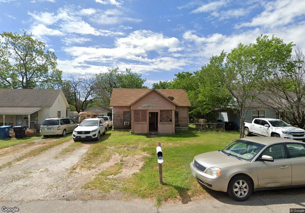
1718 W Bond St Denison, TX 75020
Estimated Value: $121,034 - $193,000
--
Bed
--
Bath
984
Sq Ft
$160/Sq Ft
Est. Value
About This Home
This home is located at 1718 W Bond St, Denison, TX 75020 and is currently estimated at $157,017, approximately $159 per square foot. 1718 W Bond St is a home located in Grayson County with nearby schools including Mayes Elementary School, Scott Middle School, and Denison High School.
Ownership History
Date
Name
Owned For
Owner Type
Purchase Details
Closed on
Sep 22, 2020
Sold by
Moreno Alicia and Moreno Alcario
Bought by
Moreno Alcario and Moreno Michael
Current Estimated Value
Purchase Details
Closed on
Jun 5, 2020
Sold by
Moreno Alcario and Moreno Alicia
Bought by
Moreno Alcario
Purchase Details
Closed on
Oct 18, 2004
Sold by
Britt Stacy
Bought by
Slagle R C and Slagle Susan
Purchase Details
Closed on
Oct 15, 2004
Sold by
Mcgehee Charlene
Bought by
Britt Stacy
Create a Home Valuation Report for This Property
The Home Valuation Report is an in-depth analysis detailing your home's value as well as a comparison with similar homes in the area
Home Values in the Area
Average Home Value in this Area
Purchase History
| Date | Buyer | Sale Price | Title Company |
|---|---|---|---|
| Moreno Alcario | -- | None Available | |
| Moreno Alcario | -- | None Available | |
| Slagle R C | -- | -- | |
| Britt Stacy | -- | -- |
Source: Public Records
Tax History Compared to Growth
Tax History
| Year | Tax Paid | Tax Assessment Tax Assessment Total Assessment is a certain percentage of the fair market value that is determined by local assessors to be the total taxable value of land and additions on the property. | Land | Improvement |
|---|---|---|---|---|
| 2025 | $58 | $41,236 | -- | -- |
| 2024 | $871 | $37,487 | $0 | $0 |
| 2023 | $58 | $34,079 | $0 | $0 |
| 2022 | $736 | $30,981 | $0 | $0 |
| 2021 | $582 | $37,164 | $20,250 | $16,914 |
| 2020 | $553 | $32,403 | $15,000 | $17,403 |
| 2019 | $525 | $32,015 | $12,450 | $19,565 |
| 2018 | $481 | $19,403 | $7,800 | $11,603 |
| 2017 | $497 | $17,778 | $6,975 | $10,803 |
| 2016 | $401 | $14,326 | $4,200 | $10,126 |
| 2015 | $335 | $11,857 | $3,150 | $8,707 |
| 2014 | $310 | $10,986 | $3,150 | $7,836 |
Source: Public Records
Map
Nearby Homes
- 1721 W Walker St Unit A and B
- 1601 W Bond St
- 2900 W Morton St
- 3130 W Morton St
- 3030 W Morton St
- 1700 W Morton St
- 3300 W Morton St
- 1905 W Morton St Unit 6
- 1905 W Morton St Unit 5
- 1905 W Morton St Unit 17
- 1905 W Morton St Unit 20
- 1905 W Morton St Unit 7
- 1915 W Bond St
- 1985 W Bond St
- 1609 W Woodard St
- 916 Leeper Dr
- 1505 W Johnson St
- 2021 W Walker St
- 2112 W Bond St
- 1531 W Main St
- 1720 W Bond St
- 1712 W Bond St
- 1704 W Bond St
- 1728 W Bond St
- 1700 W Bond St
- 1721 W Morton St
- 1730 W Bond St
- 1701 W Morton St
- 1719 W Bond St
- 1723 W Bond St
- 1711 W Bond St
- 1731 W Morton St Unit 101
- 1731 W Morton St
- 1731 W Morton St Unit 102
- 1725 W Bond St
- 601 N Bush Ave Unit 603
- 1630 W Bond St
- 1731 W Bond St
- 1626 W Bond St
- 602 N Bush Ave