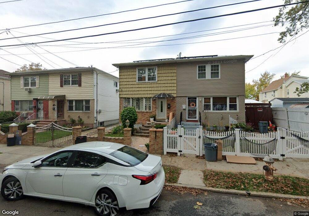
172-35 129th Ave Jamaica, NY 11434
Saint Albans NeighborhoodEstimated Value: $662,000 - $738,000
3
Beds
2
Baths
1,224
Sq Ft
$557/Sq Ft
Est. Value
About This Home
This home is located at 172-35 129th Ave, Jamaica, NY 11434 and is currently estimated at $682,345, approximately $557 per square foot. 172-35 129th Ave is a home located in Queens County with nearby schools including The Jermaine L. Green STEM Institute of Queens, Catherine & Count Basie Middle School 72, and Rochdale Early Advantage Charter School.
Ownership History
Date
Name
Owned For
Owner Type
Purchase Details
Closed on
Feb 18, 2021
Sold by
Thompson Robyn A
Bought by
Hutchinson Mike H and Williston Marsha
Current Estimated Value
Home Financials for this Owner
Home Financials are based on the most recent Mortgage that was taken out on this home.
Original Mortgage
$512,311
Outstanding Balance
$458,206
Interest Rate
2.7%
Mortgage Type
Purchase Money Mortgage
Estimated Equity
$224,139
Create a Home Valuation Report for This Property
The Home Valuation Report is an in-depth analysis detailing your home's value as well as a comparison with similar homes in the area
Home Values in the Area
Average Home Value in this Area
Purchase History
| Date | Buyer | Sale Price | Title Company |
|---|---|---|---|
| Hutchinson Mike H | $530,000 | -- |
Source: Public Records
Mortgage History
| Date | Status | Borrower | Loan Amount |
|---|---|---|---|
| Open | Hutchinson Mike H | $512,311 |
Source: Public Records
Tax History Compared to Growth
Tax History
| Year | Tax Paid | Tax Assessment Tax Assessment Total Assessment is a certain percentage of the fair market value that is determined by local assessors to be the total taxable value of land and additions on the property. | Land | Improvement |
|---|---|---|---|---|
| 2025 | $5,390 | $28,446 | $7,101 | $21,345 |
| 2024 | $3,809 | $26,837 | $7,053 | $19,784 |
| 2023 | $5,085 | $25,319 | $6,676 | $18,643 |
| 2022 | $3,187 | $31,080 | $9,840 | $21,240 |
| 2021 | $5,027 | $25,740 | $9,840 | $15,900 |
| 2020 | $4,722 | $28,260 | $9,840 | $18,420 |
| 2019 | $4,385 | $28,740 | $9,840 | $18,900 |
| 2018 | $4,003 | $21,099 | $7,076 | $14,023 |
| 2017 | $3,758 | $19,905 | $7,904 | $12,001 |
| 2016 | $3,669 | $19,905 | $7,904 | $12,001 |
| 2015 | $2,045 | $19,754 | $9,195 | $10,559 |
| 2014 | $2,045 | $18,637 | $9,217 | $9,420 |
Source: Public Records
Map
Nearby Homes
- 174-17 129th Ave
- 172-44 126th Ave
- 172-40 125th Ave
- 125-11 172nd St
- 55 128th Ave
- 174-63 128th Ave
- 176-15 130th Ave
- 173-33 Vaswani Ave
- 172-21 Baisley Blvd
- 174-41 125th Ave
- 172-38 Brocher Rd
- 130-32 177th St
- 17204 Amelia Rd
- 13012 178th St
- 12126 Irwin Place
- 17720 Leslie Rd
- 17805 130th Ave
- 17710 Troutville Rd
- 178-20 Selover Rd
- 119-73 Merrill St
- 17235 129th Ave
- 17231 129th Ave
- 17237 129th Ave
- 17237 129th Ave
- 17229 129th Ave
- 17234 128th Ave
- 17227 129th Ave
- 17238 128th Ave
- 12812 174th Place
- 17232 128th Ave
- 12810 174th Place
- 17242 128th Ave
- 17230 128th Ave
- 17223 129th Ave
- 12808 174th Place
- 17228 128th Ave
- 17221 129th Ave
- 17246 128th Ave
- 17224 128th Ave
- 17219 129th Ave