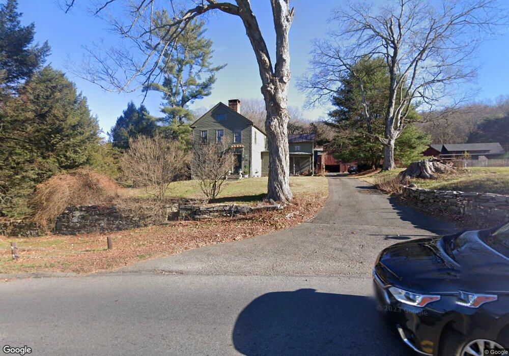
172 Aspetuck Ridge Rd New Milford, CT 06776
Estimated Value: $674,000 - $957,478
3
Beds
2
Baths
2,964
Sq Ft
$278/Sq Ft
Est. Value
About This Home
This home is located at 172 Aspetuck Ridge Rd, New Milford, CT 06776 and is currently estimated at $824,120, approximately $278 per square foot. 172 Aspetuck Ridge Rd is a home located in Litchfield County with nearby schools including Northville Elementary School, Sarah Noble Intermediate School, and Schaghticoke Middle School.
Ownership History
Date
Name
Owned For
Owner Type
Purchase Details
Closed on
Nov 20, 2020
Sold by
Walton Brian R
Bought by
Walton Paula D
Current Estimated Value
Purchase Details
Closed on
Nov 30, 1990
Sold by
Burns Mary Ellen
Bought by
Walton Brian
Home Financials for this Owner
Home Financials are based on the most recent Mortgage that was taken out on this home.
Original Mortgage
$230,000
Interest Rate
10.16%
Create a Home Valuation Report for This Property
The Home Valuation Report is an in-depth analysis detailing your home's value as well as a comparison with similar homes in the area
Home Values in the Area
Average Home Value in this Area
Purchase History
| Date | Buyer | Sale Price | Title Company |
|---|---|---|---|
| Walton Paula D | -- | None Available | |
| Walton Brian | $313,500 | -- |
Source: Public Records
Mortgage History
| Date | Status | Borrower | Loan Amount |
|---|---|---|---|
| Previous Owner | Walton Brian | $232,000 | |
| Previous Owner | Walton Brian | $230,000 |
Source: Public Records
Tax History Compared to Growth
Tax History
| Year | Tax Paid | Tax Assessment Tax Assessment Total Assessment is a certain percentage of the fair market value that is determined by local assessors to be the total taxable value of land and additions on the property. | Land | Improvement |
|---|---|---|---|---|
| 2025 | $18,873 | $618,800 | $137,480 | $481,320 |
| 2024 | $12,375 | $415,690 | $104,330 | $311,360 |
| 2023 | $12,047 | $415,690 | $104,330 | $311,360 |
| 2022 | $11,785 | $415,690 | $104,330 | $311,360 |
| 2021 | $11,627 | $415,690 | $104,330 | $311,360 |
| 2020 | $11,281 | $393,330 | $115,780 | $277,550 |
| 2019 | $11,289 | $393,330 | $115,780 | $277,550 |
| 2018 | $11,080 | $393,330 | $115,780 | $277,550 |
| 2017 | $10,718 | $393,330 | $115,780 | $277,550 |
| 2016 | $10,529 | $393,330 | $115,780 | $277,550 |
| 2015 | $9,134 | $341,460 | $115,780 | $225,680 |
| 2014 | $8,980 | $341,460 | $115,780 | $225,680 |
Source: Public Records
Map
Nearby Homes
- 18 Bayberry Ln
- 11 Tall Oaks Dr Unit 11
- 1 Tall Oaks Dr
- 12 Wells Rd
- 59 Carlson Ridge Rd
- 87 Aspetuck Village
- 77 Carlson Ridge Rd
- 74 Park Lane Rd
- 0 Chestnut Land Rd Unit 24024843
- 0 Chestnut Land Rd Unit 24024823
- 61 Park Lane Rd
- 3 Belair Dr Unit 3
- 1 Canterbury Arms
- 9 Glen Ridge Ct Unit 9
- 0 Aspetuck Ridge Rd Unit 24120976
- 22 River Rd
- 80 Glen Ridge Ct
- 2 Chatfield Rd
- 42 Twin Oaks
- 9 Riverview Ct
- 19 Sand Rd
- 0 Bayberry Ln
- 174 Aspetuck Ridge Rd
- 4 Bayberry Ln
- 11 Bayberry Ln
- 2 Bayberry Ln
- 171 Aspetuck Ridge Rd
- 37 Country Farm Ln
- 6 Bayberry Ln
- 17 Sand Rd
- 148 Aspetuck Ridge Rd
- 39 Country Farm Ln
- 18 Sand Rd
- 20 Sand Rd
- 41 Country Farm Ln
- 10 Bayberry Ln
- 8 Bayberry Ln
- 15 Bayberry Ln
- 35 Country Farm Ln
- 43 Country Farm Ln