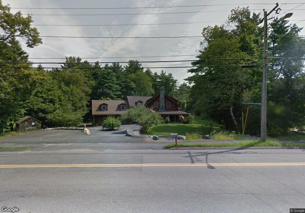
172 Chestnut St Foxboro, MA 02035
Estimated Value: $1,013,987 - $1,102,000
3
Beds
4
Baths
2,785
Sq Ft
$374/Sq Ft
Est. Value
About This Home
This home is located at 172 Chestnut St, Foxboro, MA 02035 and is currently estimated at $1,040,247, approximately $373 per square foot. 172 Chestnut St is a home located in Norfolk County with nearby schools including Foxborough High School, Foxborough Regional Charter School, and The Sage School.
Ownership History
Date
Name
Owned For
Owner Type
Purchase Details
Closed on
Nov 10, 1992
Sold by
Wheeler Brett A and Wheeler Margaret L
Bought by
Walsh Declan K and Walsh Katherine J
Current Estimated Value
Home Financials for this Owner
Home Financials are based on the most recent Mortgage that was taken out on this home.
Original Mortgage
$90,000
Interest Rate
7.99%
Mortgage Type
Purchase Money Mortgage
Purchase Details
Closed on
Apr 13, 1988
Sold by
Card Mary R
Bought by
Wheeler Brett A
Home Financials for this Owner
Home Financials are based on the most recent Mortgage that was taken out on this home.
Original Mortgage
$125,300
Interest Rate
9.78%
Mortgage Type
Purchase Money Mortgage
Create a Home Valuation Report for This Property
The Home Valuation Report is an in-depth analysis detailing your home's value as well as a comparison with similar homes in the area
Home Values in the Area
Average Home Value in this Area
Purchase History
| Date | Buyer | Sale Price | Title Company |
|---|---|---|---|
| Walsh Declan K | $121,000 | -- | |
| Wheeler Brett A | $139,250 | -- |
Source: Public Records
Mortgage History
| Date | Status | Borrower | Loan Amount |
|---|---|---|---|
| Closed | Wheeler Brett A | $90,000 | |
| Previous Owner | Wheeler Brett A | $125,300 | |
| Previous Owner | Wheeler Brett A | $40,901 |
Source: Public Records
Tax History
| Year | Tax Paid | Tax Assessment Tax Assessment Total Assessment is a certain percentage of the fair market value that is determined by local assessors to be the total taxable value of land and additions on the property. | Land | Improvement |
|---|---|---|---|---|
| 2025 | $11,985 | $906,600 | $240,100 | $666,500 |
| 2024 | $11,583 | $857,400 | $258,000 | $599,400 |
| 2023 | $11,023 | $775,700 | $246,000 | $529,700 |
| 2022 | $10,629 | $732,000 | $221,100 | $510,900 |
| 2021 | $10,237 | $694,500 | $210,200 | $484,300 |
| 2020 | $9,845 | $675,700 | $210,200 | $465,500 |
| 2019 | $9,567 | $650,800 | $210,700 | $440,100 |
| 2018 | $9,202 | $631,600 | $200,400 | $431,200 |
| 2017 | $8,765 | $582,800 | $197,100 | $385,700 |
| 2016 | $8,813 | $594,700 | $190,000 | $404,700 |
| 2015 | $8,312 | $547,200 | $142,500 | $404,700 |
| 2014 | $8,203 | $547,200 | $142,500 | $404,700 |
Source: Public Records
Map
Nearby Homes
- 165 Chestnut St Unit 2
- 147 Chestnut St Unit A
- 147 Chestnut St Unit B
- 26 Fuller Rd Unit 6
- 157 Central St
- 14 Baker St
- 67 Carpenter St
- 233 Central St
- 54 Main St Unit A
- 132 Cannon Forge Dr
- 1 Maura Elizabeth Ln
- 73 Ridge Rd
- 96 Main St Unit E4
- 155 South St
- 2 Thompson Rd
- 356 Central St
- 4 Concetta Cir
- 668 S Main St
- Lot One Old Wolomolopoag St
- Lot Two Old Wolomolopoag St
- 170 Chestnut St
- 178 Chestnut St
- 3 Jennifer Ln
- 177 Chestnut St
- 29 Sullivan Way
- 27 Sullivan Way
- 1 Sullivan Way
- 182 Chestnut St
- 25 Sullivan Way
- 7 Jennifer Ln
- 3 Sullivan Way
- 31 Sullivan Way
- 164 Chestnut St
- 164 Chestnut St
- 181 Chestnut St Unit 3
- 181 Chestnut St Unit 6
- 181 Chestnut St Unit 4
- 181 Chestnut St
- 181 Chestnut St Unit 1
- 181 Chestnut St Unit 5
Your Personal Tour Guide
Ask me questions while you tour the home.