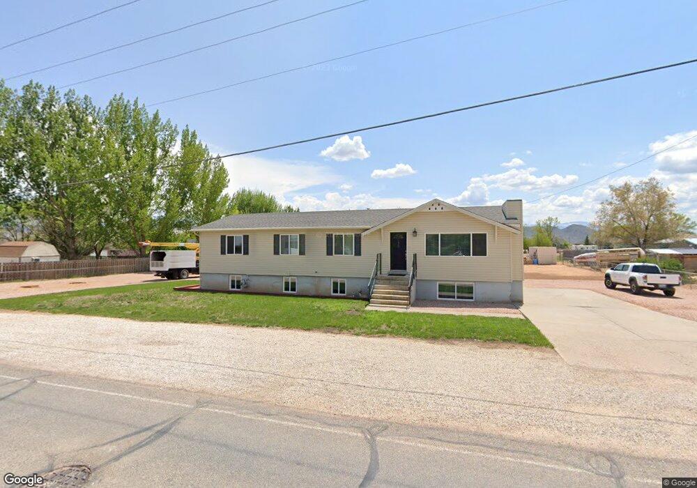
172 E Center St Aurora, UT 84620
Estimated Value: $359,000 - $402,000
5
Beds
2
Baths
3,016
Sq Ft
$125/Sq Ft
Est. Value
About This Home
This home is located at 172 E Center St, Aurora, UT 84620 and is currently estimated at $377,755, approximately $125 per square foot. 172 E Center St is a home located in Sevier County with nearby schools including Salina School, North Sevier Middle School, and North Sevier High School.
Ownership History
Date
Name
Owned For
Owner Type
Purchase Details
Closed on
May 1, 2019
Sold by
Chivers Dian Neal
Bought by
Farnsworth Kevin B and Farnsworth Steven V
Current Estimated Value
Home Financials for this Owner
Home Financials are based on the most recent Mortgage that was taken out on this home.
Original Mortgage
$78,000
Outstanding Balance
$68,152
Interest Rate
4.2%
Mortgage Type
New Conventional
Estimated Equity
$309,603
Create a Home Valuation Report for This Property
The Home Valuation Report is an in-depth analysis detailing your home's value as well as a comparison with similar homes in the area
Purchase History
| Date | Buyer | Sale Price | Title Company |
|---|---|---|---|
| Farnsworth Kevin B | -- | First American Title |
Source: Public Records
Mortgage History
| Date | Status | Borrower | Loan Amount |
|---|---|---|---|
| Open | Farnsworth Kevin B | $78,000 |
Source: Public Records
Tax History
| Year | Tax Paid | Tax Assessment Tax Assessment Total Assessment is a certain percentage of the fair market value that is determined by local assessors to be the total taxable value of land and additions on the property. | Land | Improvement |
|---|---|---|---|---|
| 2025 | $1,615 | $185,730 | $36,977 | $148,753 |
| 2024 | $1,793 | $202,215 | $33,959 | $168,256 |
| 2023 | $1,934 | $214,092 | $31,866 | $182,226 |
| 2022 | $1,947 | $195,343 | $29,019 | $166,324 |
| 2021 | $1,633 | $136,107 | $17,940 | $118,167 |
| 2020 | $1,420 | $111,199 | $17,940 | $93,259 |
| 2019 | $1,310 | $109,610 | $17,940 | $91,670 |
| 2018 | $1,057 | $78,560 | $17,040 | $61,520 |
| 2017 | $1,067 | $74,430 | $17,040 | $57,390 |
| 2016 | $844 | $69,840 | $0 | $0 |
| 2015 | $844 | $69,840 | $0 | $0 |
| 2014 | $844 | $69,260 | $0 | $0 |
Source: Public Records
Map
Nearby Homes
- 268 S 250 E
- 75 E 200 N
- 40 N 100 W
- 57 N 100 W
- 111 S 200 W
- 117 E 350 N
- 376 W 200 N
- 2200 N Hwy 260 (Approximately) W
- 2203 S 1770 W Unit 1
- 79 S 250 E
- 2720 N 250 E Unit 116
- 305 E 2690 N
- 2220 N State St Unit 14
- Tbd S State St Unit LotWP001
- 625 W Main St
- 583 W 125 N
- 340 Maple Dr
- 630 W 285 N
- 268 N Salina Creek Dr
- 550 W 285 N
Your Personal Tour Guide
Ask me questions while you tour the home.