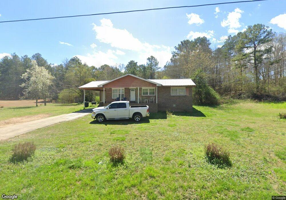
172 E Point Rd Cedartown, GA 30125
Estimated Value: $160,617 - $215,000
3
Beds
1
Bath
1,042
Sq Ft
$171/Sq Ft
Est. Value
About This Home
This home is located at 172 E Point Rd, Cedartown, GA 30125 and is currently estimated at $178,404, approximately $171 per square foot. 172 E Point Rd is a home located in Polk County with nearby schools including Cedar Christian School.
Ownership History
Date
Name
Owned For
Owner Type
Purchase Details
Closed on
Jun 15, 2021
Sold by
Alexander Jessie J
Bought by
Robinson Carlos M
Current Estimated Value
Purchase Details
Closed on
Mar 3, 1997
Sold by
Turner Robert
Bought by
Alexander Jessie J and Preston Sewell
Purchase Details
Closed on
Oct 16, 1981
Sold by
Parks Robert L
Bought by
Turner Robert E
Purchase Details
Closed on
Sep 1, 1980
Bought by
Parks Robert L
Create a Home Valuation Report for This Property
The Home Valuation Report is an in-depth analysis detailing your home's value as well as a comparison with similar homes in the area
Purchase History
| Date | Buyer | Sale Price | Title Company |
|---|---|---|---|
| Robinson Carlos M | -- | -- | |
| Alexander Jessie J | $32,000 | -- | |
| Turner Robert E | -- | -- | |
| Parks Robert L | -- | -- |
Source: Public Records
Tax History
| Year | Tax Paid | Tax Assessment Tax Assessment Total Assessment is a certain percentage of the fair market value that is determined by local assessors to be the total taxable value of land and additions on the property. | Land | Improvement |
|---|---|---|---|---|
| 2025 | $970 | $43,090 | $4,020 | $39,070 |
| 2024 | $901 | $43,090 | $4,020 | $39,070 |
| 2023 | $682 | $28,746 | $4,020 | $24,726 |
| 2022 | $597 | $25,160 | $4,020 | $21,140 |
| 2021 | $555 | $23,072 | $4,020 | $19,052 |
| 2020 | $556 | $23,072 | $4,020 | $19,052 |
| 2019 | $615 | $22,901 | $2,037 | $20,864 |
| 2018 | $613 | $22,248 | $2,037 | $20,211 |
| 2017 | $605 | $22,248 | $2,037 | $20,211 |
| 2016 | $605 | $22,248 | $2,037 | $20,211 |
| 2015 | $614 | $22,504 | $2,037 | $20,466 |
| 2014 | $643 | $23,386 | $2,919 | $20,466 |
Source: Public Records
Map
Nearby Homes
- 00 Juliette St
- 117 Hicklen Dr
- 10 Woodglen Dr
- 202 Ridgewood Rd
- 305 Greenview Ct
- 0 Coaling Rd Unit 9221-D 10352096
- 0 Coaling Rd Unit 9221-C 10352086
- 0 Coaling Rd Unit 9221 10352063
- 0 Coaling Rd Unit 9221-B 10352079
- 427 Park St
- 1101 East Ave
- 206 Turner St
- 117 Cason Rd
- 315 Jones St
- 217 E Gibson St
- 232 Tuck St
- 129 W Ellawood Ave
- 873 E Point Rd
- 815 S Main St
- 208 Highland Ave
- 162 E Point Rd
- 152 E Point Rd
- 142 E Point Rd
- 132 E Point Rd
- 1249 Lees Chapel Rd
- 1239 Lees Chapel Rd
- 1229 Lees Chapel Rd
- 1265 Lees Chapel Rd
- 1219 Lees Chapel Rd
- 118 E Point Rd
- 1275 Lees Chapel Rd
- 1209 Lees Chapel Rd
- 228 E Point Rd
- 1285 Lees Chapel Rd
- 1199 Lees Chapel Rd
- 1295 Lees Chapel Rd
- 1305 Lees Chapel Rd
- 90 E Point Rd
- 1315 Lees Chapel Rd
- 1325 Lees Chapel Rd
Your Personal Tour Guide
Ask me questions while you tour the home.