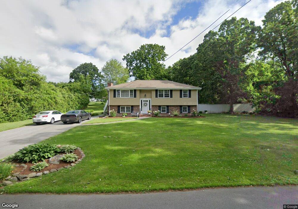
172 Fox Ave Dracut, MA 01826
Estimated Value: $579,084 - $644,000
3
Beds
2
Baths
1,362
Sq Ft
$440/Sq Ft
Est. Value
About This Home
This home is located at 172 Fox Ave, Dracut, MA 01826 and is currently estimated at $599,021, approximately $439 per square foot. 172 Fox Ave is a home located in Middlesex County with nearby schools including Greenmont Avenue School, Richardson Middle School, and Dracut Senior High School.
Ownership History
Date
Name
Owned For
Owner Type
Purchase Details
Closed on
Sep 7, 2022
Sold by
Hirschfeld Carol L
Bought by
Hirschfeld Ft
Current Estimated Value
Purchase Details
Closed on
Jan 23, 2012
Sold by
Hirschfeld Carol and Hirschfeld Ronald
Bought by
Hirschfeld Carol L
Purchase Details
Closed on
Jun 28, 1974
Bought by
Hirschfield Carol L
Create a Home Valuation Report for This Property
The Home Valuation Report is an in-depth analysis detailing your home's value as well as a comparison with similar homes in the area
Home Values in the Area
Average Home Value in this Area
Purchase History
| Date | Buyer | Sale Price | Title Company |
|---|---|---|---|
| Hirschfeld Ft | -- | None Available | |
| Hirschfeld Carol L | -- | -- | |
| Hirschfield Carol L | -- | -- |
Source: Public Records
Mortgage History
| Date | Status | Borrower | Loan Amount |
|---|---|---|---|
| Previous Owner | Hirschfield Carol L | $30,000 |
Source: Public Records
Tax History
| Year | Tax Paid | Tax Assessment Tax Assessment Total Assessment is a certain percentage of the fair market value that is determined by local assessors to be the total taxable value of land and additions on the property. | Land | Improvement |
|---|---|---|---|---|
| 2025 | $5,273 | $521,000 | $229,100 | $291,900 |
| 2024 | $5,364 | $513,300 | $218,300 | $295,000 |
| 2023 | $5,353 | $462,300 | $189,900 | $272,400 |
| 2022 | $4,944 | $402,300 | $172,700 | $229,600 |
| 2021 | $4,924 | $378,500 | $156,800 | $221,700 |
| 2020 | $4,650 | $348,300 | $152,100 | $196,200 |
| 2019 | $4,648 | $338,000 | $144,800 | $193,200 |
| 2018 | $4,502 | $318,400 | $144,800 | $173,600 |
| 2017 | $4,334 | $318,400 | $144,800 | $173,600 |
| 2016 | $4,152 | $279,800 | $139,200 | $140,600 |
| 2015 | $4,021 | $269,300 | $139,200 | $130,100 |
| 2014 | $3,837 | $264,800 | $139,200 | $125,600 |
Source: Public Records
Map
Nearby Homes
- 287 Fox Ave
- 315 Broadway Rd Unit 1
- 315 Broadway Rd Unit 7
- 54 Montaup Ave
- 1563 Bridge St
- 1573 Bridge St
- 69 Arlington St
- 26 Frank St
- 1391 Bridge St
- 23 Frank St Unit 2
- 40 Arlington Ave
- 10 Lanseigne St
- 277 Loon Hill Rd
- 175 Willard St Unit 9
- 19 Esther Way Unit Lot 10
- 700 Robbins Ave Unit 6
- 668 Robbins Ave Unit 1
- 551 Hildreth St Unit 10
- 144 Thissell Ave Unit 11
- 4 Hazelwood Ave Unit 12
- 162 Fox Ave
- 25 Tally Ho Dr
- 173 Fox Ave
- 40 Blackberry Fields Rd
- 159 Fox Ave
- 152 Fox Ave
- 147 Fox Ave
- 28 Tally Ho Dr
- 41 Blackberry Fields Rd
- 41 Tally Ho Dr
- 34 Blackberry Fields Rd
- 40 Tally Ho Dr
- 136 Fox Ave
- 130 Kenney St
- 135 Fox Ave
- 241 Fox Ave
- 238 Fox Ave
- 112 Derby St
- 35 Blackberry Fields Rd
- 28 Blackberry Fields Rd
Your Personal Tour Guide
Ask me questions while you tour the home.