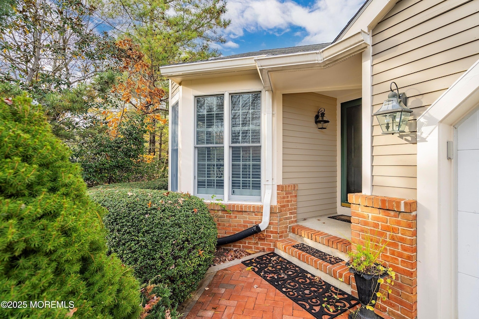
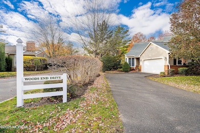
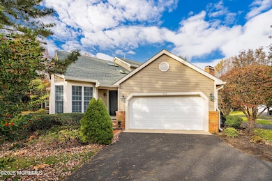
172 Woods End Dr Little Silver, NJ 07739
Estimated payment $8,991/month
Highlights
- Heated In Ground Pool
- Clubhouse
- Wood Flooring
- Point Road School Rated A
- Deck
- Main Floor Primary Bedroom
About This Home
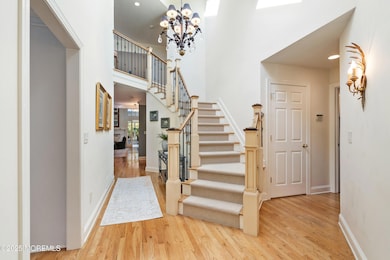
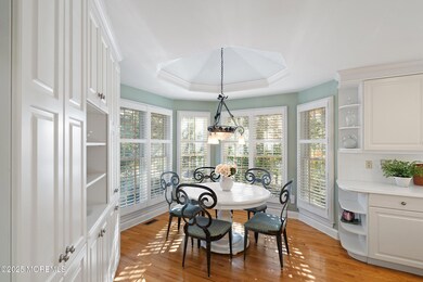
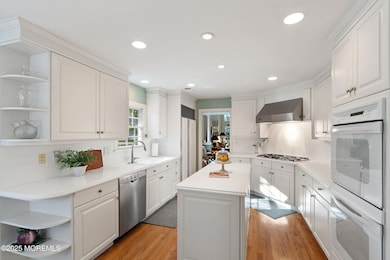
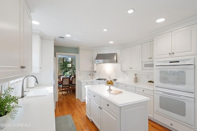
Welcome to 172 Woods End Dr., the premier ''Alderbrook'' model, renowned for its elegance and distinction. Step into a grand two-story foyer that leads to a gourmet kitchen with a sunlit breakfast nook and a sumptuous primary suite. Entertain in refined dining and living rooms or relax in the sunroom with skylights and access to an inviting deck. The upper level reveals an airy family room, two generous bedrooms, a walk-in closet, a full bath, and a dedicated exercise room. A vast basement with soaring ceilings offers exceptional storage, while Alderbrook's pet-friendly community delights with a clubhouse, heated pool, and tennis/pickleball courts and is conveniently located a few minutes from downtown Little Silver and Red Bank with fine dining and shopping.
Listing Agent
Heritage House Sotheby's International Realty License #1750844 Listed on: 11/13/2025

Townhouse Details
Home Type
- Townhome
Est. Annual Taxes
- $17,592
Year Built
- Built in 1993
Lot Details
- 3,049 Sq Ft Lot
- End Unit
- Landscaped
HOA Fees
- $700 Monthly HOA Fees
Parking
- 2 Car Direct Access Garage
- Garage Door Opener
- Driveway
- Guest Parking
- Visitor Parking
Home Design
- Mirrored Walls
- Shingle Roof
- Clap Board Siding
- Clapboard
Interior Spaces
- 3,102 Sq Ft Home
- 2-Story Property
- Central Vacuum
- Built-In Features
- Crown Molding
- Tray Ceiling
- Ceiling Fan
- Skylights
- Recessed Lighting
- Light Fixtures
- 1 Fireplace
- Blinds
- Bay Window
- French Doors
- Sliding Doors
- Family Room
- Living Room
- Dining Room
- Home Office
- Loft
- Sun or Florida Room
- Home Gym
- Basement Fills Entire Space Under The House
- Attic
Kitchen
- Breakfast Area or Nook
- Eat-In Kitchen
- Built-In Self-Cleaning Double Oven
- Gas Cooktop
- Portable Range
- Range Hood
- Microwave
- Dishwasher
- Kitchen Island
- Compactor
- Disposal
Flooring
- Wood
- Wall to Wall Carpet
- Ceramic Tile
Bedrooms and Bathrooms
- 3 Bedrooms
- Primary Bedroom on Main
- Walk-In Closet
- Primary Bathroom is a Full Bathroom
- Primary bathroom on main floor
- Dual Vanity Sinks in Primary Bathroom
- Whirlpool Bathtub
- Primary Bathroom Bathtub Only
- Primary Bathroom includes a Walk-In Shower
Laundry
- Laundry Room
- Dryer
- Washer
Home Security
- Home Security System
- Intercom
Outdoor Features
- Heated In Ground Pool
- Deck
- Exterior Lighting
Schools
- Point Road Elementary School
- Markham Place Middle School
- Red Bank Reg High School
Utilities
- Forced Air Zoned Heating and Cooling System
- Heating System Uses Natural Gas
- Programmable Thermostat
- Natural Gas Water Heater
Listing and Financial Details
- Assessor Parcel Number 25-00017-0000-00004-0000-C0141
Community Details
Overview
- Front Yard Maintenance
- Association fees include common area, exterior maint, lawn maintenance, mgmt fees, pool, snow removal
- Alderbrook Subdivision, Alderbrook, End Unit Floorplan
- On-Site Maintenance
Amenities
- Common Area
- Clubhouse
- Community Center
- Recreation Room
Recreation
- Tennis Courts
- Pickleball Courts
- Community Pool
- Snow Removal
Pet Policy
- Dogs and Cats Allowed
Security
- Resident Manager or Management On Site
Map
Home Values in the Area
Average Home Value in this Area
Tax History
| Year | Tax Paid | Tax Assessment Tax Assessment Total Assessment is a certain percentage of the fair market value that is determined by local assessors to be the total taxable value of land and additions on the property. | Land | Improvement |
|---|---|---|---|---|
| 2025 | $16,731 | $1,226,400 | $805,000 | $421,400 |
| 2024 | $16,731 | $1,042,200 | $500,000 | $542,200 |
| 2023 | $16,731 | $929,500 | $400,000 | $529,500 |
| 2022 | $14,523 | $804,200 | $300,000 | $504,200 |
| 2021 | $14,523 | $748,400 | $300,000 | $448,400 |
| 2020 | $14,965 | $738,300 | $300,000 | $438,300 |
| 2019 | $14,758 | $741,600 | $270,000 | $471,600 |
| 2018 | $14,977 | $749,600 | $300,000 | $449,600 |
| 2017 | $15,480 | $770,900 | $335,000 | $435,900 |
| 2016 | $16,666 | $840,000 | $415,000 | $425,000 |
| 2015 | $16,771 | $834,800 | $375,000 | $459,800 |
| 2014 | $16,652 | $774,500 | $375,000 | $399,500 |
Property History
| Date | Event | Price | List to Sale | Price per Sq Ft |
|---|---|---|---|---|
| 11/13/2025 11/13/25 | For Sale | $1,295,000 | -- | $417 / Sq Ft |
Purchase History
| Date | Type | Sale Price | Title Company |
|---|---|---|---|
| Deed | $830,000 | -- | |
| Deed | $420,000 | -- |
Mortgage History
| Date | Status | Loan Amount | Loan Type |
|---|---|---|---|
| Open | $581,000 | Adjustable Rate Mortgage/ARM | |
| Previous Owner | $300,000 | No Value Available |
Source: MOREMLS (Monmouth Ocean Regional REALTORS®)
MLS Number: 22534345
APN: 25-00017-0000-00004-141
Disclaimer: Certain information contained herein is derived from information provided by parties other than Homes.com. All information provided is deemed reliable, but is not guaranteed to be accurate and should be independently verified.
![]() IDX information is provided exclusively for personal, non-commercial use, and may not be used for any purpose other than to identify prospective properties consumers may be interested in purchasing.
IDX information is provided exclusively for personal, non-commercial use, and may not be used for any purpose other than to identify prospective properties consumers may be interested in purchasing.
Information is deemed reliable but not guaranteed.
- 82 Ridge Rd
- 69 Harvard Rd
- 135 Harrison Ave
- 30 Crest Dr
- 132 Harrison Ave
- 94 Park Ave
- 420 Rumson Rd
- 91 Forrest Ave
- 40 Windward Way
- 87 Rumson Rd
- 20 Windward Way
- 281 Hance Rd
- 55 Cheshire Square
- 32 Woodbine Ave
- 283 Spring St Unit 3A
- 26 Prince Place
- 57 John St
- 85 Tower Hill Dr Unit 608
- 10 Gentry Dr
- 83 Tower Hill Dr
- 146 Rumson Rd
- 283 Spring St Unit 4C
- 309 Branch Ave
- 209 Manor E Unit 3531
- 82 Manor Dr Unit 803
- 21 Worthley St
- 183 Branch Ave
- 139 Manor Dr
- 32 Manor Dr Unit 303
- 169 Manor Dr
- 299 White Rd
- 33 Prospect Ave Unit 1
- 514 River Rd Unit 516
- 516 River Rd
- 144 Spring St
- 65 Little Silver Pkwy
- 106 Wallace St Unit B
- 495 Branch Ave
- 34 Elm Place
- 127-131 Hudson Ave