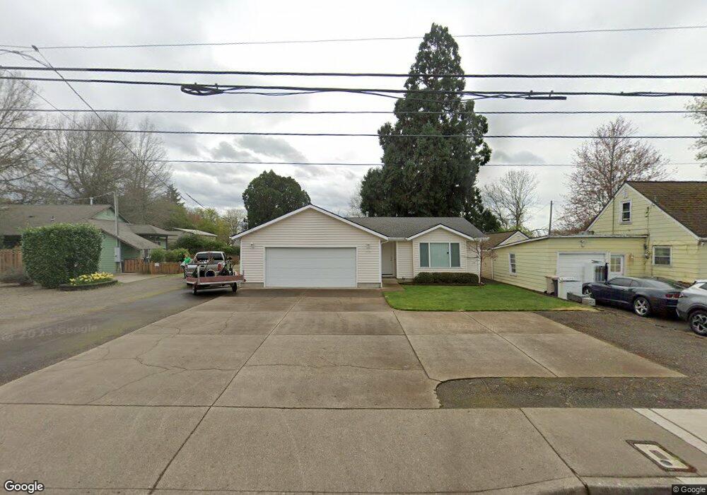
1720 Queen Ave SW Albany, OR 97321
West Albany NeighborhoodEstimated Value: $385,553 - $419,000
3
Beds
2
Baths
1,274
Sq Ft
$316/Sq Ft
Est. Value
About This Home
This home is located at 1720 Queen Ave SW, Albany, OR 97321 and is currently estimated at $402,277, approximately $315 per square foot. 1720 Queen Ave SW is a home located in Linn County with nearby schools including Takena Elementary School, Central Elementary School, and Memorial Middle School.
Ownership History
Date
Name
Owned For
Owner Type
Purchase Details
Closed on
Jun 21, 2006
Sold by
Rhoades Jeremy
Bought by
Knight Richard L and Knight Penny L
Current Estimated Value
Home Financials for this Owner
Home Financials are based on the most recent Mortgage that was taken out on this home.
Original Mortgage
$134,400
Outstanding Balance
$78,505
Interest Rate
6.55%
Mortgage Type
Fannie Mae Freddie Mac
Estimated Equity
$323,772
Create a Home Valuation Report for This Property
The Home Valuation Report is an in-depth analysis detailing your home's value as well as a comparison with similar homes in the area
Home Values in the Area
Average Home Value in this Area
Purchase History
| Date | Buyer | Sale Price | Title Company |
|---|---|---|---|
| Knight Richard L | $168,000 | Amerititle |
Source: Public Records
Mortgage History
| Date | Status | Borrower | Loan Amount |
|---|---|---|---|
| Open | Knight Richard L | $134,400 |
Source: Public Records
Tax History Compared to Growth
Tax History
| Year | Tax Paid | Tax Assessment Tax Assessment Total Assessment is a certain percentage of the fair market value that is determined by local assessors to be the total taxable value of land and additions on the property. | Land | Improvement |
|---|---|---|---|---|
| 2025 | $3,854 | $193,660 | -- | -- |
| 2024 | $3,742 | $188,020 | -- | -- |
| 2023 | $3,636 | $182,550 | $0 | $0 |
| 2022 | $3,579 | $177,240 | $0 | $0 |
| 2021 | $3,368 | $172,080 | $0 | $0 |
| 2020 | $3,323 | $167,070 | $0 | $0 |
| 2019 | $3,245 | $162,210 | $0 | $0 |
| 2018 | $3,161 | $157,490 | $0 | $0 |
| 2017 | $3,050 | $152,910 | $0 | $0 |
| 2016 | $2,791 | $148,460 | $0 | $0 |
| 2015 | $2,658 | $144,140 | $0 | $0 |
| 2014 | $2,511 | $139,950 | $0 | $0 |
Source: Public Records
Map
Nearby Homes
- 1850 17th Ave SW
- 1620 16th Ave SW
- 1510 Broadway St SW
- (next to) 2020 SW 15th Ave
- 1840 14th Ave SW
- 0 15th (Lot Unit 5) Av SW 825018
- 1420 Park Terrace SW
- 1240 SW Hop St
- 1230 SW Hop St
- 1712 25th Ave SW
- 1248 Penn St SW
- 955 21st Ave SW
- 1215 10th Ave SW
- 1510 Walnut St SW
- 1138 9th Ave SW
- 1220 Walnut St SW
- 870 14th Ave SW
- 906 11th Ave SW
- 929 10th Ave SW
- 700 14th Ave SW
- 1740 Queen Ave SW
- 1714 Queen Ave SW
- 1710 Queen Ave SW
- 1810 Queen Ave SW
- 1770 Queen Ave SW
- 1650 Queen Ave SW
- 1830 Queen Ave SW
- 1930 Broadway St SW
- 1718 17th Ave SW
- 1640 Queen Ave SW
- 1840 Queen Ave SW
- 1840 Broadway St SW
- 1760 Broadway St SW
- 1620 Queen Ave SW
- 1905 Summerfield Ct SW
- 1909 Summerfield Ct SW
- 1901 Summerfield Ct SW
- 1913 Summerfield Ct SW
- 1950 Broadway St SW
- 1720 Broadway St SW